
Knockjargon


Fort (Period Unassigned)
Site Name Knockjargon
Classification Fort (Period Unassigned)
Canmore ID 41009
Site Number NS24NW 21
NGR NS 2354 4729
Datum OSGB36 - NGR
Permalink http://canmore.org.uk/site/41009


- Council North Ayrshire
- Parish Ardrossan
- Former Region Strathclyde
- Former District Cunninghame
- Former County Ayrshire
NS24NW 21 2354 4729
(NS 2354 4729) Fort (NR)
OS 6" map (1970)
For cairn within the interior, see NS24NW 27.
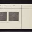
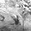
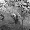
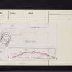
A bivallate oval fort, measuring 150 by 100ft, occupies the top of Knock Jargon. An outer line of defence consisting of a ditch with an upcast mound along parts of the outer lip covers the S approach. (Within it is cairn NS24NW 27). Visible on RAF AP's (CPE/Scot/UK 261: 4197-8).
J Smith 1895; R W Feachem 1963.
Knock Jargon fort is situated upon a rock outcrop with steep sides on all sides but the S. Surrounding the summit are the remains of two ramparts and ditches constructed upon the slopes. These ramparts are best preserved on the SE where each is broken by an entrance, 3.0m wide. The inner rampart there retains a height of 3.0m above the ditch and has a counterscarp of 0.3m. The outer rampart has a height of 2.1m and only vague traces of a counterscarp. Both ramparts are spread to a width of 3.0m, but are visible as a scatter of stones, except on the E where the outer rampart is no longer traceable.
Visited by OS (DS), 7 September 1956
This fort is generally as described by OS (DS), though the encircling ramparts now only exist as terraced scarps. At the S end of the fort there is part of a third rampart, about 0.3m high internally, 0.5m
high externally.
Revised at 1:2500.
Visited by OS (WDJ), 25 November 1965
Apart from the slight outer work on the weak S side, this fort is of bivallate construction, and shows no evidence of ditching. If there was originally any ditching, it has been effectively levelled to form terraced scarps. The internal are, of just over 0.1 hectare, is featureless apart from the cairn (NS24NW 27) which effectively occupies nearly a quarter of the internal area.
Revised at 1:2500.
Visited by OS (JRL), 11 November 1982.
Field Visit (10 September 1942)
Fort, Knock Georgan, Busbie Muir.
Knock Georgan is a crag on the summit of a hill with a roughly oval summit and precipices on the N. It is enclosed by two stone ramparts both interrupted for an entrance on the S. No built face is exposed, and the debris on the hill flanks is not conspicuous, but just W of the entrance some stones of the foundation course are exposed probably in situ. Both ramparts follow the contours of the crag, the inner one that of the summit and the outer one lower down. It fades out 15' NE of the entrance where the crag is particulalrly steep, but reappears again further N. There are suggestions of a ditch below the outer rampart on the SW.
Near the N end of the inner enciente, at the very summit of the crag, is a grass-grown stony mound about 50' in diameter strongly suggesting a cairn. A trig. station stands upon it.
Visited by RCAHMS 10 September 1942
Field Visit (2 June 1952)
This site was included within the RCAHMS Marginal Land Survey (1950-1962), an unpublished rescue project. Site descriptions, organised by county, are available to view online - see the searchable PDF in 'Digital Items'. These vary from short notes, to lengthy and full descriptions. Contemporary plane-table surveys and inked drawings, where available, can be viewed online in most cases - see 'Digital Images'. The original typecripts, notebooks and drawings can also be viewed in the RCAHMS search room.
Information from RCAHMS (GFG) 19 July 2013.
Excavation (September 1977)
Excavation of Knockjargon fort and cairn by students from the Department of Archaeology, University of Glasgow and members of the Ayrshire Archaeological Society over a period of three weeks in September 1977, with financial assistance from the University of Glasgow and the Society of Antiquaries of Scotland.
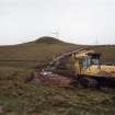
Watching Brief (22 April 2008 - 30 June 2008)
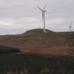
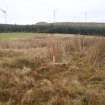
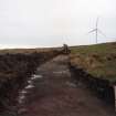
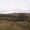
NS 23542 47317 A watching brief was undertaken from 22 April–30 June 2008, during topsoil stripping associated with the erection of three new wind turbines. The site was deemed to be of archaeological interest as the remains of Knock Jargon prehistoric hillfort and cairn, a designated scheduled ancient monument (SAM 305), are near the centre of the site, and upstanding elements of possible medieval cultivation practices are also preserved within its boundaries.
As part of the works, upstanding features potentially affected by groundworks were fenced to prevent any accidental damage during excavations. No further archaeological features or deposits were identified during the course of works. This was considered to reflect a genuine absence of below-ground features in the monitored areas, rather than their destruction.
Archive: RCAHMS
Funder: Airtricity
Kate Bain (Headland Archaeology Ltd), 2008
Note (17 July 2014 - 16 November 2016)
This fort occupies the summit of Knockjargon and is notable for the earlier burial cairn that occupies a significant proportion of its interior. Oval on plan, the fort measures 44m from NNE to SSW by 22m transversely (0.1ha) within twin stone ramparts spread about 3m in thickness and up to between 3m and 2m high externally. an additional line of defence comprising a shallow ditch with a low counterscarp bank can be seen to either side of the entrance on the S. The cairn within the interior, which is otherwise featureless, measures about 18m in diameter.
Information from An Atlas of Hillforts of Great Britain and Ireland – 16 November 2016. Atlas of Hillforts SC1238
Desk Based Assessment (November 2014 - March 2015)
A desk-based assessment and reconnaissance field survey have been carried out for the Proposed Development Site. Seventeen cultural heritage assets (sites and features) have been identified within the Proposed Development Site. These range in date from the early prehistoric (Neolithic/Bronze Age) to the post-medieval period and include a well-preserved cup and ring marked rock, which is a Scheduled Monument, several prehistoric artefact find-spots, a possible prehistoric enclosure and later post-medieval settlement and agrarian activity.
Funder: Community Windpower Ltd.
CFA Archaeology Ltd
OASIS ID: cfaarcha1-260699

