 |
On-line Digital Images |
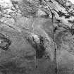
SC 1020322 |
RCAHMS Aerial Photography |
Oblique aerial view centred on the remains of the fort and cairn, taken from the NNE. |
5/2/2003 |
Item Level |
|
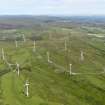 |
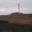
On-line Digital Images |
DP 104994 |
RCAHMS Aerial Photography Digital |
General oblique aerial view of the Busbie Muir wind farm, taken from the SW. |
25/7/2011 |
Item Level |
|
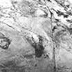 |
On-line Digital Images |
SC 1724291 |
RCAHMS Aerial Photography |
Oblique aerial view centred on the remains of the fort and cairn, taken from the NNE. |
5/2/2003 |
Item Level |
|
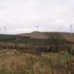 |
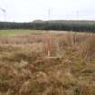
On-line Digital Images |
DP 311294 |
Records of CFA Archaeology Ltd, archaeologists, Musselburgh, East Lothian, Scotland |
Cultural heritage assessment, General view of site 6 (farmstead) with Ardrosan Wind Farm and Knock Jargon fort beyond, Blackshaw Community Windfarm |
3/12/2014 |
Item Level |
|
 |
On-line Digital Images |
DP 311295 |
Records of CFA Archaeology Ltd, archaeologists, Musselburgh, East Lothian, Scotland |
Cultural heritage assessment, Zoomed in shot of Knock Jargon Fort (SM 305), Blackshaw Community Windfarm |
3/12/2014 |
Item Level |
|
 |
On-line Digital Images |
DP 311301 |
Records of CFA Archaeology Ltd, archaeologists, Musselburgh, East Lothian, Scotland |
Cultural heritage assessment, Site 5, SE arc (turf bank) of enclosure with Knock Jargon beyond, Blackshaw Community Windfarm |
3/12/2014 |
Item Level |
|
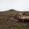 |
On-line Digital Images |
DP 353060 |
Records from Headland Archaeology Ltd, archaeologists, Edinburgh, Scotland |
Report illustration 2: 'Road excavation showing Knock Jargon Hillfort in background', Archaeological works, Ardrossan Windfarm Extension, Ardrossan, North Ayrshire |
11/6/2008 |
Item Level |
|
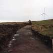 |
On-line Digital Images |
DP 353061 |
Records from Headland Archaeology Ltd, archaeologists, Edinburgh, Scotland |
Report illustration 3: 'Road to Turbine 13 under excavation', Archaeological works, Ardrossan Windfarm Extension, Ardrossan, North Ayrshire |
11/6/2008 |
Item Level |
|
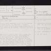 |
On-line Digital Images |
SC 2421813 |
Records of the Ordnance Survey, Southampton, Hampshire, England |
Knockjargon, NS24NW 21, Ordnance Survey index card, page number 1, Recto |
1958 |
Item Level |
|
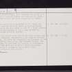 |
On-line Digital Images |
SC 2421814 |
Records of the Ordnance Survey, Southampton, Hampshire, England |
Knockjargon, NS24NW 21, Ordnance Survey index card, page number 2, Verso |
1958 |
Item Level |
|
 |
On-line Digital Images |
SC 2421815 |
Records of the Ordnance Survey, Southampton, Hampshire, England |
Knockjargon, NS24NW 21, Ordnance Survey index card, page number 1, Recto |
1958 |
Item Level |
|
 |
On-line Digital Images |
SC 2421816 |
Records of the Ordnance Survey, Southampton, Hampshire, England |
Knockjargon, NS24NW 21, Ordnance Survey index card, page number 2, Verso |
1958 |
Item Level |
|
 |
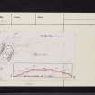
On-line Digital Images |
SC 2421817 |
Records of the Ordnance Survey, Southampton, Hampshire, England |
Knockjargon, NS24NW 21, Ordnance Survey index card, Recto |
1958 |
Item Level |
|
 |
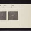
On-line Digital Images |
SC 2421818 |
Records of the Ordnance Survey, Southampton, Hampshire, England |
Knockjargon, NS24NW 21, Ordnance Survey index card, Recto |
1958 |
Item Level |
|


