Scheduled Maintenance
Please be advised that this website will undergo scheduled maintenance on the following dates: •
Tuesday 3rd December 11:00-15:00
During these times, some services may be temporarily unavailable. We apologise for any inconvenience this may cause.
Fearnoch
Chapel (Medieval)
Site Name Fearnoch
Classification Chapel (Medieval)
Canmore ID 40456
Site Number NS07NW 2
NGR NS 02102 76456
Datum OSGB36 - NGR
Permalink http://canmore.org.uk/site/40456
- Council Argyll And Bute
- Parish Inverchaolain
- Former Region Strathclyde
- Former District Argyll And Bute
- Former County Argyll
NS07NW 2 0210 7645.
(NS 0210 7644) Chapel (NR) (Ruins)
OS 6" map, Argyllshire, 2nd ed., (1900)
The remains of a small building known to have been a church (sic). A small level area to the N and E was the associated burial ground. Although looked upon as an antiquity, there is no tradition regarding it.
Name Book 1863.
Listed an an "ancient Catholic Chapel".
Argyll County Council 1914.
The walls of this chapel, though tumbled, are quite obvious. There is a well near the chapel (NS07NW 3) and also surrounding garth walls.
M Paterson 1970.
The remains of a sub-rectangular building (probably the chapel) measuring 5.2m NE-SW by 3.5m with rounded corners on the W and S sides. The walls are about 1m in height and thickness with an entrance 0.8m wide on the SE side. The building is enclosed by a turf-covered earth-and-stone bank 1.5m high with an entrance in the W.
Visited by OS (I A) 24 November 1972.
NS 0210 7644. The remains of a probable chapel as described in the field report of 24 11 72. The enclosing wall measures 15.0m N-S by 10.0m
Surveyed at 1:10,000.
Visited by OS (B S) 14 October 1976.
Field Visit (March 1987)
The remains of this chapel are situated at an elevation of 100m OD in a south-facing valley 400m E of Fearnoch farmhouse and some 550m from the E shore of Loch Riddon. It occupies the confined summit of a low rocky ridge to whose alignment it conforms, measuring 5.2m from NE to SW by 3.6m within walls up to 1.5m in thickness. These stand to a height of about 1m and in the upper part are of loose drystone rubble, probably indicating an agricultural re-use of the building, associated with adjacent turf field-dykes. The lower parts of the walls are of older construction and the plan of the building, with its entrance towards the SW end of the SE wall, supports its traditional identification as an early chapel.
The chapel stands in an enclosure measuring about 15m from NE to SW by 10m within a turf-and-stone boundary-wall having an entrance at the S angle.
RCAHMS 1992, visited March 1987
Measured Survey (18 March 1987)
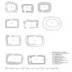
RCAHMS surveyed Fearnoch chapel on 18 March 1987 with plane-table and alidade producing a site plan at a scale of 1:400. The plan was redrawn in ink and published at a scale of 1:1000 (RCAHMS 1992, 74). The plan of the chapel was also included in an illustration of comparative plans of early chapels published at a scale of 1:250 (RCAHMS 1992, 6C).


