|
Photographs and Off-line Digital Images |
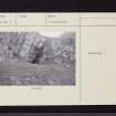
A 382 |
Records of the Ordnance Survey, Southampton, Hampshire, England |
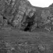
General view of cave from the west.
Neg 1, OS. |
23/11/1976 |
Item Level |
|
|
Manuscripts |
MS 2256 |
Records of CFA Archaeology Ltd, archaeologists, Musselburgh, East Lothian, Scotland |
Report: Coastal Zone Assessment Survey. Firth of Clyde and Isle of Bute. CFA Archaeology Ltd, 2004.
Written by M Cressey and M Johnson |
8/2004 |
Item Level |
|
 |
On-line Digital Images |
SC 1152247 |
Records of the Ordnance Survey, Southampton, Hampshire, England |
General view of cave from the W |
23/11/1976 |
Item Level |
|
|
Digital Files (Non-image) |
GV 004572 |
Records of the Royal Commission on the Ancient and Historical Monuments of Scotland (RCAHMS), Edinbu |
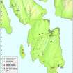
Map: Distribution of Mesolithic and Neolithic sites and artefacts. |
8/2010 |
Item Level |
|
|
Digital Files (Non-image) |
GV 004574 |
Records of the Royal Commission on the Ancient and Historical Monuments of Scotland (RCAHMS), Edinbu |
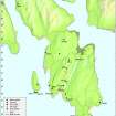
Map: Distribution of sites and artefacts of the Late Bronze Age and Iron Age. |
8/2010 |
Item Level |
|
 |
On-line Digital Images |
DP 097420 |
Records of the Royal Commission on the Ancient and Historical Monuments of Scotland (RCAHMS), Edinbu |
Map - Distribution of Mesolithic and Neolithic sites and artefacts. |
8/2010 |
Item Level |
|
 |
On-line Digital Images |
DP 097422 |
Records of the Royal Commission on the Ancient and Historical Monuments of Scotland (RCAHMS), Edinbu |
Map - Distribution of sites and artefacts of the Late Bronze Age and Iron Age. |
8/2010 |
Item Level |
|
|
Prints and Drawings |
DC 26800 |
Records of the Society of Antiquaries of Scotland, Edinburgh, Scotland |
Plan of Dunagoil area, Bute. |
|
Item Level |
|
 |
On-line Digital Images |
DP 132423 |
Records of the Royal Commission on the Ancient and Historical Monuments of Scotland (RCAHMS), Edinbu |
General shot of cave and rock shelter |
13/9/2010 |
Item Level |
|
|
Manuscripts |
MS 7154/1 |
Records of CFA Archaeology Ltd, archaeologists, Musselburgh, East Lothian, Scotland |
Coastal Survey Form: Coastal Zone Assessment Survey. Firth of Clyde and Isle of Bute. CFA Archaeology Ltd, 2004.
Written by M Cressey and M Johnson |
8/2004 |
Item Level |
|
|
Manuscripts |
MS 7154/2 |
Records of CFA Archaeology Ltd, archaeologists, Musselburgh, East Lothian, Scotland |
Coastal Survey Form: Coastal Zone Assessment Survey. Firth of Clyde and Isle of Bute. CFA Archaeology Ltd, 2004.
Written by M Cressey and M Johnson |
12/2003 |
Item Level |
|
 |
On-line Digital Images |
SC 2420229 |
Records of the Ordnance Survey, Southampton, Hampshire, England |
Bute, Dunagoil, NS05SE 11, Ordnance Survey index card, Recto |
1958 |
Item Level |
|
 |
On-line Digital Images |
SC 2420230 |
Records of the Ordnance Survey, Southampton, Hampshire, England |
Bute, Dunagoil, NS05SE 11, Ordnance Survey index card, page number 1, Recto |
1958 |
Item Level |
|
 |
On-line Digital Images |
SC 2420231 |
Records of the Ordnance Survey, Southampton, Hampshire, England |
Bute, Dunagoil, NS05SE 11, Ordnance Survey index card, Recto |
1958 |
Item Level |
|
 |
On-line Digital Images |
SC 2420232 |
Records of the Ordnance Survey, Southampton, Hampshire, England |
Bute, Dunagoil, NS05SE 11, Ordnance Survey index card, Recto |
1958 |
Item Level |
|
|
All Other |
551 166/1/1 |
Records of the Ordnance Survey, Southampton, Hampshire, England |
Archaeological site card index ('495' cards) |
1947 |
Sub-Group Level |
|


