
Bute, Blackpark Plantation


Cross Incised Stone (Early Medieval), Standing Stone(S) (Prehistoric), Stone Circle (Bronze Age)(Possible), Stone Setting (Neolithic) - (Bronze Age)
Site Name Bute, Blackpark Plantation
Classification Cross Incised Stone (Early Medieval), Standing Stone(S) (Prehistoric), Stone Circle (Bronze Age)(Possible), Stone Setting (Neolithic) - (Bronze Age)
Alternative Name(s) Kingarth; Langalchorad
Canmore ID 40258
Site Number NS05NE 8
NGR NS 09164 55666
Datum OSGB36 - NGR
Permalink http://canmore.org.uk/site/40258


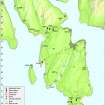


- Council Argyll And Bute
- Parish Kingarth
- Former Region Strathclyde
- Former District Argyll And Bute
- Former County Buteshire
NS05NE 8 09164 55666
(NS 0917 5566) Stone Circle (NR) (Rems of).
OS 6" map, (1957)
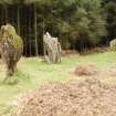
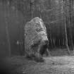
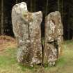
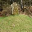
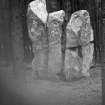
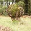
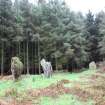
Three stones, set in an arc, stand over 7ft high in the wood at Kingarth. Two are conglomerate, an unusual stone for such monuments, while the third, 9ft high and 23ft in circumference, is of schist. There were seven stones here when Blain described them in the late 18th century.
D N Marshall 1963.
One of the conglomerate stones broke at ground level after a gale in 1974. Excavation round it showed it had been set 0.65m in the ground, its total length being 2.45m. The packing stones were exposed.
D N Marshall 1975.
The remains of a stone circle as described in the previous information. The southernmost stone, damaged in 1974 and now restored, measures 2.2m high by 1.3m by 0.6m thick. The middle of the three stones is 2.8m high by 2.2m by 1.0m and has been split almost in two by frost action. The third stone, supported by an iron bar, is 2.2m high and measures 1.1m by 0.5m at its base but broadens to 2.0m by 0.5m near its top. There are no other stones to be seen nearby.
Surveyed at 1:2500.
Visited by OS (B S), 25 October 1976.
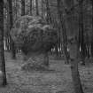
These three standing stones, which are situated in a clearing in Blackpark Plantation, are generally as described by the Ordnance Survey. The stones are depicted on the 1st edition of the OS 6-inch map (Buteshire 1869, sheet CCXV), but since then at least one of them has fallen and been re-erected, and it is not at all clear what form the original setting took. The southernmost stone, a large block of conglomerate, bears numerous graffiti, including what appears to be a small incised cross with expanded terminals.
Visited by RCAHMS (AGCH, JH), 5 May 2009.
Sketch Drawing (1818)
Reference (1893)
Field Visit (May 1943)
This site was recorded as part of the RCAHMS Emergency Survey, undertaken by Angus Graham and Vere Gordon Childe during World War 2. The project archive has been catalogued during 2013-2014 and the material, which includes notebooks, manuscripts, typescripts, plans and photographs, is now available online.
Information from RCAHMS (GF Geddes) 2 December 2014.
Reference (1972)
Excavation (1975)
One of the conglomerate stones broke at ground level after a gale in 1974. Excavation round it showed it had been set 0.65m in the ground, its total length being 2.45m. The packing stones were exposed.
D N Marshall 1975.
Conservation (1975)
Reference (28 June 1976)
Three stones, set in an arc, stand over 7ft high in the wood at Kingarth. Two are conglomerate, an unusual stone for such monuments, while the third, 9ft high and 23ft in circumference, is of schist. There were seven stones here when Blain described them in the late 18th century.
D N Marshall 1963.
One of the conglomerate stones broke at ground level after a gale in 1974. Excavation round it showed it had been set 0.65m in the ground, its total length being 2.45m. The packing stones were exposed.
D N Marshall 1975.
Photographic Survey (16 March 1976)
Field Visit (25 October 1976)
The remains of a stone circle as described in the previous information. The southernmost stone, damaged in 1974 and now restored, measures 2.2m high by 1.3m by 0.6m thick. The middle of the three stones is 2.8m high by 2.2m by 1.0m and has been split almost in two by frost action. The third stone, supported by an iron bar, is 2.2m high and measures 1.1m by 0.5m at its base but broadens to 2.0m by 0.5m near its top. There are no other stones to be seen nearby.
Surveyed at 1:2500.
Visited by OS (B S) 25 October 1976.
Reference (1976)
Field Visit (5 May 2009)
These three standing stones, which are situated in a clearing in Blackpark Plantation, are generally as described by the Ordnance Survey, though the exact form of the original monument is unknown. The current disposition of the stones is the same as that depicted on the 1st edition of the OS 6-inch map (Buteshire 1869, sheet CCXV), but since then at least one of them has fallen and been re-erected. On the S face of the southernmost stone, a large block of conglomerate, there is a small incised cross with expanded terminals and more recent graffiti.
Visited by RCAHMS (AGCH, JH), 5 May 2009.
Reference (2009)
Watching Brief (11 October 2011 - 12 October 2011)
NS 0916 5566 A watching brief was carried out 11–12 October 2011 during topsoil removal associated with car access improvements close to a scheduled stone setting. The area lay due N of the monument, on the N side of a track linking the planned road with the B881. The area affected by the work measured 30m E–W by 5m N–S. The removal of c0.25m of humic topsoil revealed a bioturbated orange-brown sandy gravel subsoil. No significant archaeological features or artefacts were recorded.
Archive: Bute Museum, Mount Stuart and RCAHMS (intended)
Funder: Discover Bute Landscape Partnership Scheme
Field Visit (23 September 2019)
The plantation was felled between June 2018 and September 2019 leaving the three orthostats exposed.
Visited by HES, (ATW, ARG, AKK), 23 September 2019
Photographic Survey

