
Bute, Ardnahoe


Fort (Iron Age), Rig And Furrow (Medieval) - (Post Medieval)
Site Name Bute, Ardnahoe
Classification Fort (Iron Age), Rig And Furrow (Medieval) - (Post Medieval)
Canmore ID 40242
Site Number NS05NE 2
NGR NS 06636 57440
Datum OSGB36 - NGR
Permalink http://canmore.org.uk/site/40242


- Council Argyll And Bute
- Parish Kingarth
- Former Region Strathclyde
- Former District Argyll And Bute
- Former County Buteshire
NS05NE 2 06636 57440.
(NS 0664 5742) Dun (NR).
OS 6" map (1957)
This fort occupies the oval summit of a high rock over- looking Scalpsie Bay. It measures about 1/4 acre. The landward side has been defended by a substantial, semi-oval earth and stone rampart, 126ft long. Only a few stones remain.
J K Hewison 1893-5.
A small oval fort generally as described by the previous authority. It appears to have measured 30.0m EW by 25.0m transversely. There are no traces of any defence work on the steeply sloping S arc. A gap 8.0m wide was made recently in the E side during the erection of a new fence around the seaward side of the fort. The original entrance may have been here as there is no other gap to be seen. The single rampart, remaining only on the N, is 6.0m wide and 0.8m high.
Surveyed at 1:10 000.
Visited by OS (B S) 28 October 1976.
A small roughly circular earthwork formed by a ditch and external bank. Part of the bank was removed recently by the farmer at Ardnahoe, who confirmed that there was no stone in it.
Information from K A Steer, 15 July 1975.
This small fort is situated on a promontory that extends from a raised beach 250m SW of Ardnahoe farmsteading (NS05NE 108). Roughly oval on plan, it measures about 25m from E to W by 23m transversely, within an area defined by the steep face of the raised beach on the S and SE, and elsewhere by a rampart and external ditch. The rampart has been reduced to a mound 6m in thickness and up to 0.8m in height; a broad gap on the NE probably incorporates an original entrance gap. Rig-and-furrow, orientated NE and SW, and measuring 3m in breadth, is visible across the interior of the fort.
Visited by RCAHMS (AGCH) 6 May 2009.
Field Visit (27 May 1943)
This site was recorded as part of the RCAHMS Emergency Survey, undertaken by Angus Graham and Vere Gordon Childe during World War 2. The project archive has been catalogued during 2013-2014 and the material, which includes notebooks, manuscripts, typescripts, plans and photographs, is now available online.
Information from RCAHMS (GF Geddes) 2 December 2014.
Field Visit (31 August 1972)
This fort occupies the oval summit of a high rock over- looking Scalpsie Bay. It measures about 1/4 acre. The landward side has been defended by a substantial, semi-oval earth and stone rampart, 126ft long. Only a few stones remain.
Visited by OS (IFC) 31 August 1972
Field Visit (15 July 1975)
A small roughly circular earthwork formed by a ditch and external bank. Part of the bank was removed recently by the farmer at Ardnahoe, who confirmed that there was no stone in it.
Information from K A Steer, 15 July 1975.
Field Visit (28 October 1976)
A small oval fort generally as described by the previous authority. It appears to have measured 30.0m EW by 25.0m transversely. There are no traces of any defence work on the steeply sloping S arc. A gap 8.0m wide was made recently in the E side during the erection of a new fence around the seaward side of the fort. The original entrance may have been here as there is no other gap to be seen. The single rampart, remaining only on the N, is 6.0m wide and 0.8m high.
Surveyed at 1:10 000.
Visited by OS (B S) 28 October 1976.
Field Visit (6 May 2009)
This small fort is situated on a promontory that extends from a raised beach 250m SW of Ardnahoe farmsteading (NS05NE 108). Roughly oval on plan, it measures about 25m from E to W by 23m transversely, within an area defined by the steep face of the raised beach on the S and SE, and elsewhere by a rampart and external ditch. The rampart has been reduced to a mound 6m in thickness and up to 0.8m in height; a broad gap on the NE probably incorporates an original entrance gap. Rig-and-furrow, orientated NE and SW, and measuring 3m in breadth, is visible across the interior of the fort.
Visited by RCAHMS (AGCH) 6 May 2009.
Measured Survey (1 October 2010)
RCAHMS surveyed the fort at Ardnahoe, Bute on 1 October 2010 with plane table and self-reducing alidade at a scale of 1:500.
Note (9 July 2014 - 23 May 2016)
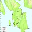
The remains of a small promontory work are situated at the edge of the escarpment forming the old shoreline SW of Ardnahoe. The ground falls away steeply on all sides except the N, where a rampart some 6m in thickness by up to 0.8m in height, with an external ditch between 4.3m and 5.2m in breadth, has been drawn across the neck of the promontory in a gentle arc. Traces of rig and furrow cultivation can be seen within the interior, which measures about 30m from E to W immediately to the rear of the rampart by 25m transversely (0.05ha). In 1943 the entrance was noted on the NE, close to the E margin of the promontory, but this sector was mutilated about 1975.
Information from An Atlas of Hillforts of Great Britain and Ireland – 23 May 2016. Atlas of Hillforts SC1151

