
Arran, Monamore, Meallach's Grave


Chambered Cairn (Neolithic), Bead (Glass)(Prehistoric), Blade (Flint)(Prehistoric), Scraper (Tool) (Flint)(Prehistoric)
Site Name Arran, Monamore, Meallach's Grave
Classification Chambered Cairn (Neolithic), Bead (Glass)(Prehistoric), Blade (Flint)(Prehistoric), Scraper (Tool) (Flint)(Prehistoric)
Canmore ID 40086
Site Number NS02NW 10
NGR NS 01752 28890
Datum OSGB36 - NGR
Permalink http://canmore.org.uk/site/40086


- Council North Ayrshire
- Parish Kilbride
- Former Region Strathclyde
- Former District Cunninghame
- Former County Buteshire
NS02NW 10 01752 28890.
(NS 0173 2888) Meallach's Grave (NAT)
(Cairn) (NR).
OS 6" map, (1924)
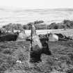
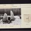
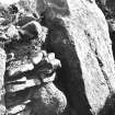
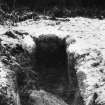
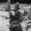
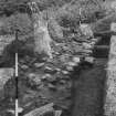
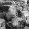
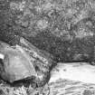
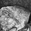
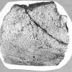
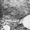
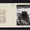
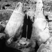
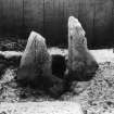
Meallach's Grave: Clyde group, long cairn. This cairn has been greatly robbed and its edges are indefinite, the whole area now being turf-covered. The cairn material remains about 3' high round the chamber. The extent of the cairn was approximately established in 1961 by probing (MacKie 1966). It seems to have been more or less trapezoidal about 45ft long from the portal stones, widening to a maximum width of about 35ft at 14ft behind the facade. A cutting running SE from the centre of the chamber showed at the edge of the cairn several slabs which may have fallen from a kerb of dry-stone walling. The cairn was composed of large irregular stones and earth.
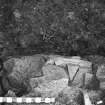
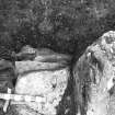
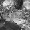
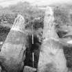
At the SW end of the cairn, an impressive facade was revealed in the 1961 excavations. It measures 26ft 9 ins across, consisting of 8 orthostats set in a shallow and somewhat irregular curve about 3ft 6ins deep. They were linked by dry walling, still standing up 2ft 4ins high. A thick deposit of grey earth and accumulated in the forecourt, to a depth of 2-3ft against the facade. In it were 21 spreads of charcoal, and many scattered fragments at varying depths. A sill-stone 1ft 2ins deep, was firmly wedged between the portals. In front of the sill-stone was a small paved area. Over the grey earth was a deliberate blocking, of stones in brown earth; its upper surface formed a rough pavement. Two radiocarbon dates were obtained from charcoal in the grey soil deposits. The earlier, from near the base of the deposit, gave a date of 3160 +/- 110 BC, the later, laid down shortly before the blocking, gave a date of 2240 +/- 110 BC.
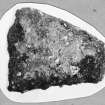
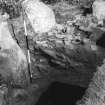
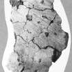
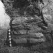
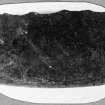
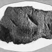
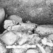
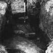
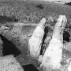
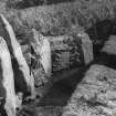
The chamber was excavated in 1902 (b). It measures 13ft 3ins by from 2ft 9ins to 4ft 6ins and is divided into 3 compartments. The artifacts found in the 1961 excavations are in the Hunterian Museum; they comprise pottery sherds (A 1961 13, 19 and 20), flint blade (A 1961 18) flint scraper (A 1961 12), pitchstone and quartz fragments (A 1961 22) and a later blue dumb-bell shaped glass bead (A 1961 61). Items found in 1902 are in the NMAS: pottery sherds and pitchstone fragments (EO 272).
T H Bryce 1903; E W MacKie 1967; A S Henshall 1972, visited 1972.
NS 01762 8888. Meallach's Grave (name confirmed) is a Chambered Cairn as described by Miss Henshall.
Surveyed at 1:10 000.
Visited by OS (B S) 28 November 1977.
Publication Account (1985)
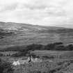
This cairn is of particular interest as it is the only neolithic tomb on Arran to have been excavated in recent times and, although not especially well preserved, it is still worth walking through the forest to visit such a classic site. Much of the mound has been removed, but it is trapezoidal on plan measuring about 13.5m from north-east to south-west by a maximum of 10.5m at the south-west end. The most prominent features visible today are the three-compartment chamber and some of the stones of the facade which lie at the south-west end of the cairn. Unlike the other Clyde-type long cairns at Cam Ban (no. 99) and East Bennan (no. 100), the forecourt is rather shallow and unsymmetrical, but the facade is well-built with panels of drystone walling (now buried) between the orthostats (uprights). These are roughly graded in height with the tallest standing at the centre, and the middle pair also form portal stones on either side of the entrance to the chamber. The side-slabs of the chamber are set in the characteristic overlapping plan with the compartments divided by septal slabs. At the entrance to the chamber there is a second pair of portal stones placed behind the facade stones and behind them there was a sill-stone, which was probably necessary to prevent soil creeping into the chamber. Bryce cleared out the chamber in 1901 but the only finds were a few tiny fragments of pottery and several chips of Arran pitchstone.
In 1961 Euan MacKie carried out further excavation on the cairn, this time concentrating on the forecourt. Here he found evidence for activity during the period of the cairn's use, comprising fires and 'occupation material' which is normally interpreted as the remains of ritual fires and feasting associated with the cult of the dead. Radiocarbon assays from the bottom and top of this material gave dates of about 3950 BC and 2940 BC respectively which, taken crudely, give a span of use of the cairn of about a millennium. It is, however, difficult to be certain of the true significance of these dates but we can be sure that cairns of this type could have remained in use over a long period. Once the community who built the cairn decided that no more burials were to take place, the forecourt (where all the important rituals had occurred) and the entrance to the chamber were deliberately blocked and filled in with earth and stone, thus sealing the cairn.
Information from ‘Exploring Scotland’s Heritage: The Clyde Estuary and Central Region’, (1985).
Condition Survey (8 September 2014 - 12 September 2014)
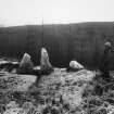
AOC Archaeology Group undertook a survey of seven chambered cairns and one four poster stone circle on Arran was undertaken for the purposes of providing a baseline record, for conservation management and for archaeological study.
Information from OASIS ID: aocarcha1-200509 (G Cavers) 2014
Note (11 June 2019 - 13 June 2019)
The location, classification and period of this site have been reviewed.
HES Survey and Recording 11-13 June 2019

