 |
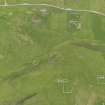
On-line Digital Images |
DP 082006 |
RCAHMS Aerial Photography Digital |
Oblique aerial view of the farmsteads, the Broch of Underhoull and the field systems, looking NE. |
15/6/2010 |
Item Level |
|
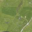 |
On-line Digital Images |
DP 082009 |
RCAHMS Aerial Photography Digital |
Oblique aerial view of the farmsteads, looking NW. |
15/6/2010 |
Item Level |
|
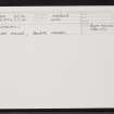 |
On-line Digital Images |
SC 2336057 |
Records of the Ordnance Survey, Southampton, Hampshire, England |
Unst, Underhoull, HP50SE 20, Ordnance Survey index card, Recto |
1958 |
Item Level |
|
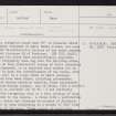 |
On-line Digital Images |
SC 2336058 |
Records of the Ordnance Survey, Southampton, Hampshire, England |
Unst, Underhoull, HP50SE 20, Ordnance Survey index card, page number 1, Recto |
1958 |
Item Level |
|
 |
On-line Digital Images |
SC 2336059 |
Records of the Ordnance Survey, Southampton, Hampshire, England |
Unst, Underhoull, HP50SE 20, Ordnance Survey index card, page number 2, Verso |
1958 |
Item Level |
|


