|
Photographs and Off-line Digital Images |
B 61967 |
|
|
|
Item Level |
|
|
Photographs and Off-line Digital Images |
B 61968 |
|
|
|
Item Level |
|
|
Photographs and Off-line Digital Images |
B 61969 |
|
|
|
Item Level |
|
|
Photographs and Off-line Digital Images |
B 61970 |
|
|
|
Item Level |
|
|
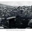
Photographs and Off-line Digital Images |
SC 454133 |
|
Scan of slide showing St Michael's Chapel, Bute. |
|
Item Level |
|
|
Manuscripts |
MS 2256 |
Records of CFA Archaeology Ltd, archaeologists, Musselburgh, East Lothian, Scotland |
Report: Coastal Zone Assessment Survey. Firth of Clyde and Isle of Bute. CFA Archaeology Ltd, 2004.
Written by M Cressey and M Johnson |
8/2004 |
Item Level |
|
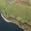 |
On-line Digital Images |
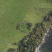
DP 057319 |
RCAHMS Aerial Photography Digital |
Oblique aerial view centred on the ruin of the chapel and graveyard and the remains of the farmstead, taken from the SW. |
31/10/2008 |
Item Level |
|
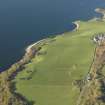 |
On-line Digital Images |
DP 057320 |
RCAHMS Aerial Photography Digital |
Oblique aerial view centred on the ruin of the chapel and graveyard and the remains of the farmstead, taken from the SSE. |
31/10/2008 |
Item Level |
|
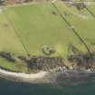 |
On-line Digital Images |
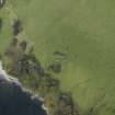
DP 062639 |
RCAHMS Aerial Photography Digital |
Oblique aerial view centred on the remains of the chapel and graveyard, taken from the W. |
6/2/2009 |
Item Level |
|
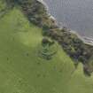 |
On-line Digital Images |
DP 067130 |
RCAHMS Aerial Photography Digital |
Oblique aerial view centred on the chapel, taken from the NE. |
6/10/2009 |
Item Level |
|
 |
On-line Digital Images |
DP 067132 |
RCAHMS Aerial Photography Digital |
Oblique aerial view centred on the chapel, taken from the NE. |
6/10/2009 |
Item Level |
|
 |
On-line Digital Images |
DP 067135 |
RCAHMS Aerial Photography Digital |
Oblique aerial view centred on the chapel, taken from the SSW. |
6/10/2009 |
Item Level |
|
 |
On-line Digital Images |
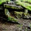
DP 069240 |
|
The eroding slabs of the cist from the SW |
19/5/2009 |
Item Level |
|
 |
On-line Digital Images |
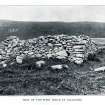
SC 1157820 |
|
Detail of the west gable (Hewison 1893, 112). |
17/9/2009 |
Item Level |
|
 |
On-line Digital Images |
SC 1157821 |
|
Detail of the interior (Hewison 1893, 114). |
17/9/2009 |
Item Level |
|
|
Digital Files (Non-image) |
GV 004575 |
Records of the Royal Commission on the Ancient and Historical Monuments of Scotland (RCAHMS), Edinbu |
Map: Distribution of Early Historic and Medieval sites and artefacts. |
8/2010 |
Item Level |
|
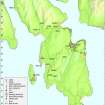 |
On-line Digital Images |
DP 097423 |
Records of the Royal Commission on the Ancient and Historical Monuments of Scotland (RCAHMS), Edinbu |
Map - Distribution of Early Historic and Medieval sites and artefacts. |
8/2010 |
Item Level |
|
|
Manuscripts |
MS 7154/1 |
Records of CFA Archaeology Ltd, archaeologists, Musselburgh, East Lothian, Scotland |
Coastal Survey Form: Coastal Zone Assessment Survey. Firth of Clyde and Isle of Bute. CFA Archaeology Ltd, 2004.
Written by M Cressey and M Johnson |
8/2004 |
Item Level |
|
|
Manuscripts |
MS 7154/2 |
Records of CFA Archaeology Ltd, archaeologists, Musselburgh, East Lothian, Scotland |
Coastal Survey Form: Coastal Zone Assessment Survey. Firth of Clyde and Isle of Bute. CFA Archaeology Ltd, 2004.
Written by M Cressey and M Johnson |
12/2003 |
Item Level |
|
 |
On-line Digital Images |
SC 2419333 |
Records of the Ordnance Survey, Southampton, Hampshire, England |
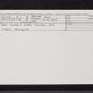
Bute, St Michael's Chapel, NR97SE 3, Ordnance Survey index card, page number 1, Recto |
1958 |
Item Level |
|
 |
On-line Digital Images |
SC 2419334 |
Records of the Ordnance Survey, Southampton, Hampshire, England |
Bute, St Michael's Chapel, NR97SE 3, Ordnance Survey index card, page number 2, Verso |
1958 |
Item Level |
|
 |
On-line Digital Images |
SC 2419335 |
Records of the Ordnance Survey, Southampton, Hampshire, England |
Bute, St Michael's Chapel, NR97SE 3, Ordnance Survey index card, Recto |
1958 |
Item Level |
|
|
All Other |
551 166/1/1 |
Records of the Ordnance Survey, Southampton, Hampshire, England |
Archaeological site card index ('495' cards) |
1947 |
Sub-Group Level |
|


