 |
On-line Digital Images |
SC 730457 |
Records of the Society of Antiquaries of Scotland, Edinburgh, Scotland |
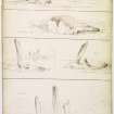
Drawing showing monuments at Machrie Moor, Arran in 1832. |
1832 |
Item Level |
|
 |
On-line Digital Images |
SC 730460 |
Records of the Society of Antiquaries of Scotland, Edinburgh, Scotland |
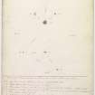
Annotated pencil drawing. |
1832 |
Item Level |
|
 |
On-line Digital Images |
SC 1319572 |
Records of Historic Scotland, Edinburgh, Scotland |
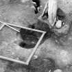
Excavation photograph : Postholes of main ring, by stone 10. From top - F1284, 1285, 1286, 1287, 1470 and 1288. |
1986 |
Item Level |
|
 |
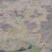
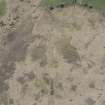
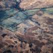
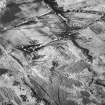
On-line Digital Images |
DP 252787 |
Historic Environment Scotland |
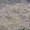
Oblique aerial view. |
3/5/2017 |
Item Level |
|
 |
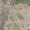
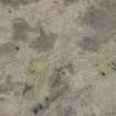
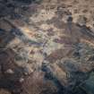
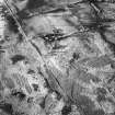
On-line Digital Images |
DP 252788 |
Historic Environment Scotland |
Oblique aerial view. |
3/5/2017 |
Item Level |
|
 |
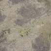
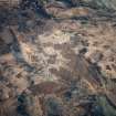
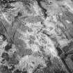
On-line Digital Images |
DP 252789 |
Historic Environment Scotland |
Oblique aerial view. |
3/5/2017 |
Item Level |
|
 |
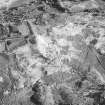
On-line Digital Images |
DP 252791 |
Historic Environment Scotland |
Oblique aerial view. |
3/5/2017 |
Item Level |
|
 |
On-line Digital Images |
DP 252795 |
Historic Environment Scotland |
Oblique aerial view. |
3/5/2017 |
Item Level |
|
 |
On-line Digital Images |
DP 252796 |
Historic Environment Scotland |
Oblique aerial view. |
3/5/2017 |
Item Level |
|
 |
On-line Digital Images |
DP 252797 |
Historic Environment Scotland |
Oblique aerial view. |
3/5/2017 |
Item Level |
|
 |
On-line Digital Images |
DP 252798 |
Historic Environment Scotland |
Oblique aerial view. |
3/5/2017 |
Item Level |
|
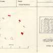 |
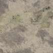
On-line Digital Images |
SC 1671720 |
Records of the Ordnance Survey, Southampton, Hampshire, England |
Plan, copied from Ordnance Survey Record Card |
13/9/1977 |
Item Level |
|
 |
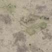
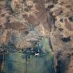
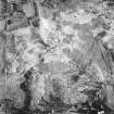
On-line Digital Images |
SC 1723819 |
RCAHMS Aerial Photography |
Machrie Moor, oblique aerial view, centred on a group of stone circles. |
13/12/1996 |
Item Level |
|
 |
On-line Digital Images |
SC 1723821 |
RCAHMS Aerial Photography |
Machrie Moor, oblique aerial view, centred on three stone circles. |
13/12/1996 |
Item Level |
|
 |
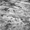
On-line Digital Images |
SC 1723823 |
RCAHMS Aerial Photography |
Machrie Moor, oblique aerial view, centred on three stone circles. |
13/12/1996 |
Item Level |
|
 |
On-line Digital Images |
SC 1723825 |
RCAHMS Aerial Photography |
Machrie Moor, oblique aerial view, centred on two stone circles. |
13/12/1996 |
Item Level |
|
 |
On-line Digital Images |
SC 1783126 |
RCAHMS Aerial Photography |
Machrie Moor, oblique aerial view, centred on two stone circles. |
13/12/1996 |
Item Level |
|
 |
On-line Digital Images |
SC 1783128 |
RCAHMS Aerial Photography |
Machrie Moor, oblique aerial view. |
13/12/1996 |
Item Level |
|
 |
On-line Digital Images |
SC 1783129 |
RCAHMS Aerial Photography |
Machrie Moor, oblique aerial view, centred on three stone circles. |
13/12/1996 |
Item Level |
|
 |
On-line Digital Images |
SC 1783131 |
RCAHMS Aerial Photography |
Machrie Moor, oblique aerial view, centred on two stone circles. |
13/12/1996 |
Item Level |
|
 |
On-line Digital Images |
SC 1783132 |
RCAHMS Aerial Photography |
Machrie Moor, oblique aerial view, centred on three stone circles. |
13/12/1996 |
Item Level |
|
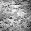 |
On-line Digital Images |
SC 1783143 |
RCAHMS Aerial Photography |
Machrie Moor and Moss Farm, oblique aerial view, with three stone circles in the top half of the photograph and a hut-circle and possible hut-circle in the bottom half. |
13/12/1996 |
Item Level |
|
 |
On-line Digital Images |
SC 1783144 |
RCAHMS Aerial Photography |
Machrie Moor and Moss Farm, oblique aerial view, with the stone circles in the top half of the photograph and a hut-circle and possible hut-circle in the bottom half. |
13/12/1996 |
Item Level |
|
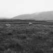 |
On-line Digital Images |
SC 1905360 |
Records of the Ordnance Survey, Southampton, Hampshire, England |
From SW |
13/9/1977 |
Item Level |
|


