
Arran, Cnoc Ballygowan


Enclosure (Post Medieval)(Possible), Fort (Prehistoric)(Possible)
Site Name Arran, Cnoc Ballygowan
Classification Enclosure (Post Medieval)(Possible), Fort (Prehistoric)(Possible)
Canmore ID 39617
Site Number NR92NW 1
NGR NR 9202 2911
Datum OSGB36 - NGR
Permalink http://canmore.org.uk/site/39617


- Council North Ayrshire
- Parish Kilmory
- Former Region Strathclyde
- Former District Cunninghame
- Former County Buteshire
NR92NW 1 9202 2911
(NR 9202 2911) Fort (NR).
OS 1" map, (1960)
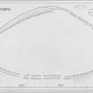
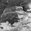
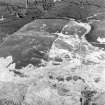
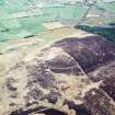
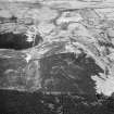
NR 9202 2911 Unfinished fort (OS 6" map annotated by A L F Rivet, undated) An oval area of six acres on the summit of Cnoc Ballygown, enclosed by a weak bank and ditch is visible on air photographs. The ditch is up to 1.0m in depth, following the contours and enclosing an area some 900ft NE-SW by 500ft transversely. No entrances were observed, but on the N side, the easiest approach, there were several poorly defined causeways. The bank appears to be composed entirely of earth. On the W side the ground falls steeply away, but no use has been made of this, the ditch being some 50ft further up the hill.
(Visible on OS air photographs 58.980: 3047-9).
Visited by OS (D G B) 24 September 1953.
An unfinished fort generally as described above enclosing an area of about 3.0 hectares, survives as a contour-following terrace 2.0m wide around all but the north-east side. On the south-east and north sides this terrace becomes a shallow waterfilled ditch. There are two adjacent breaks in the N side, but they are too ill-defined to identify as causeways.
The interior rises to a level top which is approximately 10.0m above the terrace.
Surveyed at 1:2500 and at 1:10 000.
Visited by OS (B S) 13 October 1977.
Field Visit (6 August 1957)
This site was included within the RCAHMS Marginal Land Survey (1950-1962), an unpublished rescue project. Site descriptions, organised by county, are available to view online - see the searchable PDF in 'Digital Items'. These vary from short notes, to lengthy and full descriptions. Contemporary plane-table surveys and inked drawings, where available, can be viewed online in most cases - see 'Digital Images'. The original typecripts, notebooks and drawings can also be viewed in the RCAHMS search room.
Information from RCAHMS (GFG) 19 July 2013.
Note (5 April 2016 - 18 May 2016)
What are supposed to be the remains of an unfinished fort enclose the summit of Cnoc Ballygown, a prominent hill on the E of the valley between Shishkine and Blackwaterfoot. Oval on plan, the enclosure measures about 260m from NNE to SSW by 160m transversely within what has been described as a shallow ditch with an external bank, which along the W flank is reduced to a terrace; the discontinuous character of the ditch and the presence of causeways at several points along its length are cited as evidence of gang work and that the fortification was never completed. In truth, this interpretation is wishful thinking, conceived at a time when numerous unfinished works were being identified across the country; in this case the perimeter is no more than a post-medieval turf dyke built with material extracted from the shallow ditch or stripping scar to enclose the domed hilltop.
Information from An Atlas of Hillforts of Great Britain and Ireland – 18 May 2016. Atlas of Hillforts SC4276
Note (28 November 2018)
The location, classification and period of this site have been reviewed.
HES Survey and Recording 28 November 2018

