|
Prints and Drawings |
DC 13242 |
Records of the Royal Commission on the Ancient and Historical Monuments of Scotland (RCAHMS), Edinbu |
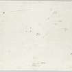
Survey drawing; Nether Largie standing stones, plan. |
12/1982 |
Item Level |
|
 |
On-line Digital Images |
DP 017919 |
RCAHMS Aerial Photography Digital |
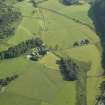
General oblique aerial view of the Kilmartin valley centred on the remains of the chambered cairn, standing stones, stone setting and cairns and the farmstead and school, taken from the S. |
27/6/2006 |
Item Level |
|
 |
On-line Digital Images |
DP 017920 |
RCAHMS Aerial Photography Digital |
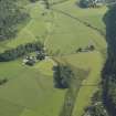
General oblique aerial view of the Kilmartin valley centred on the remains of the chambered cairn, standing stones, stone setting and cairns and the farmstead and school, taken from the S. |
27/6/2006 |
Item Level |
|
 |
On-line Digital Images |
DP 017921 |
RCAHMS Aerial Photography Digital |
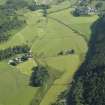
General oblique aerial view of the Kilmartin valley centred on the remains of the chambered cairn, standing stones, stone setting and cairns and the farmstead and school, taken from the S. |
27/6/2006 |
Item Level |
|
 |
On-line Digital Images |
DP 017950 |
RCAHMS Aerial Photography Digital |
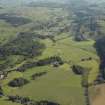
General oblique aerial view of the Kilmartin valley centred on the remains of the chambered cairn, standing stones, stone setting and cairns and the farmstead and school, taken from the SSW. |
27/6/2006 |
Item Level |
|
 |
On-line Digital Images |
DP 199236 |
Records of the Royal Commission on the Ancient and Historical Monuments of Scotland (RCAHMS), Edinbu |
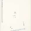
Survey drawing; Nether Largie standing stones, plan. |
12/1982 |
Item Level |
|
 |
On-line Digital Images |
DP 199237 |
Records of the Royal Commission on the Ancient and Historical Monuments of Scotland (RCAHMS), Edinbu |
Publication drawing; Nether Largie standing stones, plan. |
1982 |
Item Level |
|
 |
On-line Digital Images |
SC 2418258 |
Records of the Ordnance Survey, Southampton, Hampshire, England |
Nether Largie, NR89NW 45, Ordnance Survey index card, Recto |
1958 |
Item Level |
|
 |
On-line Digital Images |
SC 2418259 |
Records of the Ordnance Survey, Southampton, Hampshire, England |
Nether Largie, NR89NW 45, Ordnance Survey index card, Recto |
1958 |
Item Level |
|
|
All Other |
551 166/1/1 |
Records of the Ordnance Survey, Southampton, Hampshire, England |
Archaeological site card index ('495' cards) |
1947 |
Sub-Group Level |
|


