 |
On-line Digital Images |
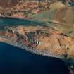
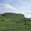
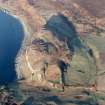
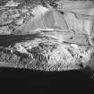
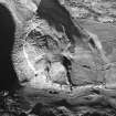
SC 624803 |
RCAHMS Aerial Photography |
The Doon, Drumadoon, oblique aerial view, taken from the WNW. |
13/12/1996 |
Item Level |
|
 |
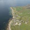
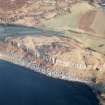
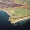
On-line Digital Images |
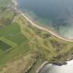
DP 159702 |
RCAHMS Aerial Photography Digital |
Oblique aerial view of Shiskine Golf Course and fort, looking to the S. |
6/6/2013 |
Item Level |
|
 |
On-line Digital Images |
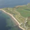
DP 159705 |
RCAHMS Aerial Photography Digital |
Oblique aerial view of Shiskine Golf Course and fort, looking to the NNE. |
6/6/2013 |
Item Level |
|
 |
On-line Digital Images |
DP 159707 |
RCAHMS Aerial Photography Digital |
Oblique aerial view of Shiskine Golf Course and fort, looking to the NNW. |
6/6/2013 |
Item Level |
|
 |
On-line Digital Images |
DP 159708 |
RCAHMS Aerial Photography Digital |
Oblique aerial view of Shiskine Golf Course and fort, looking to the NW. |
6/6/2013 |
Item Level |
|
 |
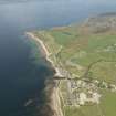
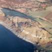
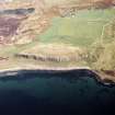
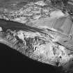
On-line Digital Images |
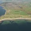
DP 159709 |
RCAHMS Aerial Photography Digital |
General oblique aerial view of Drumadoon Bay with Blackwaterfoot in the foreground, looking to the NW. |
6/6/2013 |
Item Level |
|
 |
On-line Digital Images |
DP 233314 |
Historic Environment Scotland |
Oblique aerial view. |
12/5/2016 |
Item Level |
|
 |
On-line Digital Images |
SC 1599750 |
Records of the Ordnance Survey, Southampton, Hampshire, England |
OS |
1977 |
Item Level |
|
 |
On-line Digital Images |
SC 1599751 |
Records of the Ordnance Survey, Southampton, Hampshire, England |
OS |
1977 |
Item Level |
|
 |
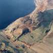
On-line Digital Images |
SC 1723780 |
RCAHMS Aerial Photography |
The Doon, Drumadoon, oblique aerial view, taken from the WNW. |
13/12/1996 |
Item Level |
|
 |
On-line Digital Images |
SC 1723781 |
RCAHMS Aerial Photography |
The Doon, Drumadoon, oblique aerial view, taken from the W. |
13/12/1996 |
Item Level |
|
 |
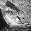
On-line Digital Images |
SC 1723782 |
RCAHMS Aerial Photography |
The Doon, Drumadoon, oblique aerial view, taken from the SW. |
13/12/1996 |
Item Level |
|
 |
On-line Digital Images |
SC 1723783 |
RCAHMS Aerial Photography |
The Doon, Drumadoon, oblique aerial view, taken from the S. |
13/12/1996 |
Item Level |
|
 |
On-line Digital Images |
SC 1723784 |
RCAHMS Aerial Photography |
The Doon, Drumadoon, oblique aerial view, taken from the SSE. |
13/12/1996 |
Item Level |
|
 |
On-line Digital Images |
SC 1723785 |
RCAHMS Aerial Photography |
The Doon, Drumadoon, oblique aerial view, taken from the SE. |
13/12/1996 |
Item Level |
|
 |
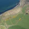
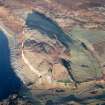
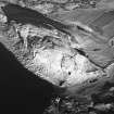
On-line Digital Images |
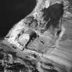
SC 1723793 |
RCAHMS Aerial Photography |
Oblique aerial view centred on the remains of the fort with the farmsteading adjacent, taken from the WNW. |
12/5/2005 |
Item Level |
|
 |
On-line Digital Images |
SC 1723794 |
RCAHMS Aerial Photography |
Oblique aerial view centred on the remains of the fort with the farmsteading adjacent, taken from the SW. |
12/5/2005 |
Item Level |
|
 |
On-line Digital Images |
SC 1783079 |
RCAHMS Aerial Photography |
The Doon, Drumadoon, oblique aerial view, taken from the W. |
13/12/1996 |
Item Level |
|
 |
On-line Digital Images |
SC 1783080 |
RCAHMS Aerial Photography |
The Doon, Drumadoon, oblique aerial view, taken from the WSW. |
13/12/1996 |
Item Level |
|
 |
On-line Digital Images |
SC 1783081 |
RCAHMS Aerial Photography |
The Doon, Drumadoon, oblique aerial view, taken from the SW. |
13/12/1996 |
Item Level |
|
 |
On-line Digital Images |
SC 1783082 |
RCAHMS Aerial Photography |
The Doon, Drumadoon, oblique aerial view, taken from the SSW. |
13/12/1996 |
Item Level |
|
 |
On-line Digital Images |
SC 1783083 |
RCAHMS Aerial Photography |
The Doon, Drumadoon, oblique aerial view, taken from the S. |
13/12/1996 |
Item Level |
|
 |
On-line Digital Images |
SC 1783084 |
RCAHMS Aerial Photography |
The Doon, Drumadoon, oblique aerial view, taken from the SSE. |
13/12/1996 |
Item Level |
|
 |
On-line Digital Images |
SC 2259442 |
Records of the Ordnance Survey, Southampton, Hampshire, England |
OS |
1977 |
Item Level |
|


