|
Photographs and Off-line Digital Images |
AG 2407 PO |
Cambridge University Collection for Aerial Photography |
|
1968 |
Item Level |
|
|
Photographs and Off-line Digital Images |
AG 2405 PO |
Cambridge University Collection for Aerial Photography |
|
1968 |
Item Level |
|
|
Photographs and Off-line Digital Images |
AG 2406 PO |
Cambridge University Collection for Aerial Photography |
|
1968 |
Item Level |
|
|
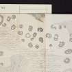
Prints and Drawings |
AGD 540/1 |
Records of the Royal Commission on the Ancient and Historical Monuments of Scotland (RCAHMS), Edinbu |
RCAHMS Survey.
Plan. |
1967 |
Item Level |
|
|
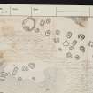
Prints and Drawings |
AGD 540/2 |
Records of the Royal Commission on the Ancient and Historical Monuments of Scotland (RCAHMS), Edinbu |
Plan. |
|
Item Level |
|
|
Photographs and Off-line Digital Images |
E 21383 P |
|
Photographic copy of plan showing a hut-circle and shieling huts.
RCAHMS Kintyre Inventroy, fig. 190. |
|
Item Level |
|
|
Photographs and Off-line Digital Images |
SC 1927860 |
Cambridge University Collection for Aerial Photography |
|
1968 |
Item Level |
|
|
Photographs and Off-line Digital Images |
SC 1927861 |
Cambridge University Collection for Aerial Photography |
|
1968 |
Item Level |
|
|
Photographs and Off-line Digital Images |
SC 1927862 |
Cambridge University Collection for Aerial Photography |
|
1968 |
Item Level |
|
 |
On-line Digital Images |
SC 2416806 |
Records of the Ordnance Survey, Southampton, Hampshire, England |
Talatoll, NR75SE 4, Ordnance Survey index card, page number 1, Recto |
1958 |
Item Level |
|
 |
On-line Digital Images |
SC 2416807 |
Records of the Ordnance Survey, Southampton, Hampshire, England |
Talatoll, NR75SE 4, Ordnance Survey index card, page number 2, Verso |
1958 |
Item Level |
|
 |
On-line Digital Images |
SC 2416808 |
Records of the Ordnance Survey, Southampton, Hampshire, England |
Talatoll, NR75SE 4, Ordnance Survey index card, Recto |
1958 |
Item Level |
|
 |
On-line Digital Images |
SC 2416809 |
Records of the Ordnance Survey, Southampton, Hampshire, England |
Talatoll, NR75SE 4, Ordnance Survey index card, Recto |
1958 |
Item Level |
|
 |
On-line Digital Images |
SC 2416810 |
Records of the Ordnance Survey, Southampton, Hampshire, England |
Talatoll, NR75SE 4, Ordnance Survey index card, Recto |
1958 |
Item Level |
|
|
All Other |
551 166/1/1 |
Records of the Ordnance Survey, Southampton, Hampshire, England |
Archaeological site card index ('495' cards) |
1947 |
Sub-Group Level |
|


