
Talatoll


Hut Circle (Prehistoric), Shieling Hut(S) (Post Medieval)
Site Name Talatoll
Classification Hut Circle (Prehistoric), Shieling Hut(S) (Post Medieval)
Alternative Name(s) Talatell
Canmore ID 38952
Site Number NR75SE 4
NGR NR 7754 5299
NGR Description NR 775 530 and NR 778 528
Datum OSGB36 - NGR
Permalink http://canmore.org.uk/site/38952


- Council Argyll And Bute
- Parish Kilcalmonell
- Former Region Strathclyde
- Former District Argyll And Bute
- Former County Argyll
Field Visit (June 1967)
NR 778 528
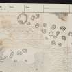
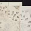
Shielings, Talatoll.
The remains of an extensive cluster of shieling huts stand in open moorland 1.6km SE of Talatoll at an altitude of about 140m OD. The majority of the huts are grouped around two rocky hillocks standing on the left side of an unnamed burn that descends towards the nearby shore of Loch Ciaran.
The huts vary a good deal in size and shape, as they do in their state of preservation, and it is unlikely that all were in occupation at the same time. They appear to have been constructed of stone and turf, the entrance doorways often being formed of stone slabs on end; some of the huts appear to have opposed entrance-doorways. Of the 43 or so huts that can now be identified, the majority comprised a single chamber; a few evidently incorporated two chambers, however, while at least two were three-chambered. The smallest of the single-chambered huts measures about 2'7 m by 2'1 m over all, and the largest of the three-chambered huts about 6'1 m by 4'9 m over all; the average thickness of the walls appears to have been about 0'9 m. There is nothing to suggest that any of the huts had stone-corbelled roofs, and it is probable that they were covered with turf and branches. Towards the SW end of the site there is a circular enclosure measuring 12.2m in external diameter. A hut is situated in the SE sector of this enclosure.
About 180m S of these remains, a smaller group of similar huts stands on the opposite side of the burn.
No traditions relating to the practice of shieling appear to be preserved in the locality, but the area of rough pasture surrounding the hut sites is still in regular use for the summer grazing of cattle.
RCAHMS 1971, visited June 1967.
Field Visit (13 August 1973)
NR75SE 4 7780 5280.
(NR 7780 5288) Old Corn Kilns (NAT)
OS 6" map, (1924)
About 20 shielings and other amorphous mounds were located in scattered groups along the burn, and are generally as described by the RCAHMS. The circular enclosure was not located.
Visited by OS (D W R) 13 August 1973.
Field Visit (7 February 1978)
NR75SE 4 7780 5280.
Centred on NR 775 530 and NR 778 528 are the shieling groups as described and planned by the RCAHMS. The enclosure, at NR 7754 5299, is a hut circle 10.0m internal diameter. The interior is levelled, and the wall, in the main reduced to an overgrown band of rubble measuring 2.0m broad and 0.3m high, retains enough of an inner facing to demonstrate boulder-slab construction. An entrance is in the southern arc. The "hut" in the SE sector is a shieling.
Surveyed at 1:10 000.
Visited by OS (J M) 7 February 1978.

