
Jura, Cladh Chlainn Iain


Chambered Cairn (Neolithic)
Site Name Jura, Cladh Chlainn Iain
Classification Chambered Cairn (Neolithic)
Alternative Name(s) Poll A Cheo; Strone
Canmore ID 38244
Site Number NR56SW 1
NGR NR 5048 6316
Datum OSGB36 - NGR
Permalink http://canmore.org.uk/site/38244


- Council Argyll And Bute
- Parish Jura
- Former Region Strathclyde
- Former District Argyll And Bute
- Former County Argyll
NR56SW 1 5047 6315
(NR 5048 6316) Cladh Chlainn Iain (NR) Stones (NAT)
OS 6" map, Argyllshire, 2nd ed., (1900)
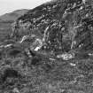
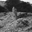
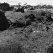
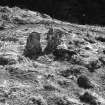
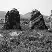
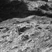
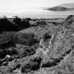
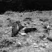
Cladh Chlainn Iain; This monument occupies an unusual position on a small shelf a short way above the shore. Though much disturbed, the remains suggest a small, wrecked tomb of Clyde type. The main feature is a pair of stones facing ENE which appear to be the portals of a chamber. They are 2ft9ins wide, 3ft high and 1ft2ins apart. To the SE, a smaller stone appears to have formed the corner of a narrow facade. The SE side of the chamber is represented by a slab on edge 4ft5ins long. Eight and a half feet behind the portal stones is a kerb of spaced small stones running in a straight line at right angles to the axis of the chamber. At the S corner, a stone is aligned NE. These stones suggest the remains of a roughly square enclosure, presumably a secondary feature. Little cairn material remains, and it is mainly turf-covered; the cairn seems to have extended 37ft 6ins SW from the portal stones, and is here edged by two large kerb stones, indicating a rounded end to the cairn. Cairn material extends about 5ft in front of the portal stones. Across the chamber, the cairn is about 20ft wide. (cf NR57SE 7)
A S Henshall 1972.
Generally as described by Miss Henshall. However, there is some doubt to the alleged SW extent of the cairn as it would include apparent "living" rock.
Surveyed at 1/10,000.
Visited by OS (J M) 16 May 1978.
Field Visit (May 1976)
This cairn is situated about 1.3 km S of Strone, on a small shelf on the right bank of the Abhainn na Sroine, close to the shore of Poll a' Cheo. At its ENE end the cairn is 5.3 m broad and about 0.4 m in greatest height. Its length, however, is difficult to establish; the three kerb-stones to the rear of the chamber suggest a length of only 4 m, but an alternative suggestion, favoured by Henshall (1972), is that the turf-covered stony ridge extending for a further 6 m indicates the original outline of the cairn, and this is shown by a dashed line on the plan. In front of the portal stones the cairn material is visible over a distance of about 1.5 m, and this doubtless represents the original blocking of the tomb. The simple chamber is set behind a crescentic facade, with portal stones measuring 1.5 m and 0.9 m in height respectively and placed some 0.35 m apart. Only the S side-slab of the chamber (aligned ENE-WSW) survives, measuring 1.4 m in length, 0.15 m in thickness, and exposed to a height of 0.5 m.
RCAHMS 1984, visited May 1976
Measured Survey (May 1976)
RCAHMS surveyed this chambered cairn with plane-table and alidade at a scale of 1:100. The resultant plan was redrawn in ink and published at the reduced scale of 1:250 (RCAHMS 1984, fig. 48A).

