
Islay, Kilslevan


Lime Kiln(S) (Period Unassigned), Township (Period Unassigned)
Site Name Islay, Kilslevan
Classification Lime Kiln(S) (Period Unassigned), Township (Period Unassigned)
Alternative Name(s) Cill Sleabahn
Canmore ID 38117
Site Number NR46NW 22
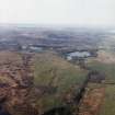
NGR NR 4199 6710
NGR Description Centred on NR 419 671
Datum OSGB36 - NGR
Permalink http://canmore.org.uk/site/38117


- Council Argyll And Bute
- Parish Killarow And Kilmeny
- Former Region Strathclyde
- Former District Argyll And Bute
- Former County Argyll
NR46NW 22 centred on 4199 6710
Corn kiln, 6ft internally with walls 6' wide and 6' high. Possible fire slab in SE quadrant.
Shanks 1971
Abandoned 18th/19th century township of at least eight longhouses, the largest 29m by 4m, and several subsidiary buildings, enclosures and two corn-drying kilns.
Visited by OS (NKB) 19 April 1979
Manuscript annotation on RCAHMS working map indicates 'late township group... not attracting special comment'.
(Undated) information in NMRS
A township comprising seven unroofed buildings, two of which are long buildings, four enclosures and three kilns, each annotated as Old Limekiln, is depicted on the OS 1st edition 6-inch map (Argyllshire 1867, sheet cxcviii). Nine unroofed buildings, one of which is a long building and another is L-shaped, and three enclosures, one of which is incomplete, are shown on the current edition of the OS 1:10000 map (1981).
Information from RCAHMS (SAH) 2 November 1998

