
Islay, Loch Ballygrant


Building (Medieval), Crannog (Period Unknown), Cruck Framed Building (Medieval), Island Dwelling (Medieval)
Site Name Islay, Loch Ballygrant
Classification Building (Medieval), Crannog (Period Unknown), Cruck Framed Building (Medieval), Island Dwelling (Medieval)
Alternative Name(s) Loch A' Chuirn
Canmore ID 38112
Site Number NR46NW 19
NGR NR 4057 6638
Datum OSGB36 - NGR
Permalink http://canmore.org.uk/site/38112


- Council Argyll And Bute
- Parish Killarow And Kilmeny
- Former Region Strathclyde
- Former District Argyll And Bute
- Former County Argyll
Field Visit (August 1975)
NR46NW 19.00 4057 6638
NR46NW 19.01 NR 405 663 Loch Ballygrant Quern
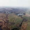
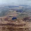
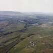
The northernmost and largest of the three small islands in Loch Ballygrant (formerly known as Loch a' Chuirn) is occupied by the remains of about half a dozen stone buildings, all now somewhat obscured by a dense growth of trees and shrubs. The island itself is roughly oval in plan, measuring about 50m from NE to SW by 35m transversely. Although the island appears to be of natural origin, the central portion comprising an outcrop of rock which rises some 5m above the surrounding water-level, the surface area has evidently been considerably enlarged artificially by the deposit of boulders and small stones round the perimeter.
The level of the loch is now controlled by sluices and there is evidence to suggest that during the period in which the island was occupied the water-level was somewhat lower than at present. Thus, at the date of visit a boulder jetty on the NW side of the island lay some 0.5m beneath water-level, as did also a corresponding jetty on the opposite shore of the loch. Since there is no trace of a causeway linking the island to the mainland, it is probable that access was obtained by means of boats plying between these two jetties. Immediately off the S shore of the island there is an islet, apparently of artificial construction, which now measures about 10m in diameter; although linked to the main island by means of a roughly built causeway, this islet contains no visible remains of buildings.
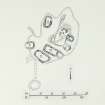
The buildings on the main island are mostly of subrectangular plan and all are constructed of drystone masonry, their walls having an average thickness of 1.2m. The summit of the rock outcrop is occupied by a building (A) measuring about 9m by 5.5m over all; there are traces of a doorway in the NW wall. Immediately to the SE of building A, and lying at right angles to it, there is a well-preserved building (B) measuring 7.2m by 5m over all. The walls stand to a maximum height of about 1.5m, the SW wall incorporating a doorway and the NE wall what appears to be a cruck-slot. To the S of building B, and running almost parallel to it, there are slight traces of another building (C) of similar size.
Building D, which may have been the principal dwelling-house, occupies the most favoured site on the island, a patch of level ground lying a little to the S of the rock knoll; it measures about 13m by 7m over all and incorporates at its SE end an outshot which increases the total length o the building to 18m. The main portion of the building appears to have been provided with opposed doorways in the side-walls. Immediately to the SW of building D and running parallel to it there are the remains of a large but poorly preserved building (E), whose SW wall appears to be founded upon a boulder revetment constructed upon the loch shore. Building F, a poorly preserved structure of horseshoe-shaped plan, stands close to the jetty, to the NE of which there is a well-preserved building (G) measuring 11m by 7m over all and incorporating traces of a doorway in one of the side-walls.
This appears to be the island known as Ellan Charrin, which Monro lists in 1549 among the possession of the MacLeans of Duart, and it is probable that the existing remains belong to about this period.
Visited August 1975.
RCAHMS 1984.
Measured Survey (August 1975)
RCAHMS surveyed the crannog at Loch Ballygrant at a scale of 1:200. The plan was redrawn in ink and published at a reduced scale (RCAHMS 1984, fig. 155B).

