
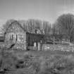
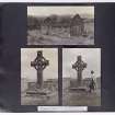
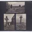
Islay, Kildalton Chapel


Burial Ground (Medieval), Carved Stone(S) (Period Unassigned), Church (Medieval)
Site Name Islay, Kildalton Chapel
Classification Burial Ground (Medieval), Carved Stone(S) (Period Unassigned), Church (Medieval)
Alternative Name(s) Kildalton Church; Kildalton Old Parish Church; Kildalton High Cross And Church; Kildalton, Former Parish Church
Canmore ID 38071
Site Number NR45SE 3
NGR NR 45797 50818
Datum OSGB36 - NGR
Permalink http://canmore.org.uk/site/38071


- Council Argyll And Bute
- Parish Kildalton And Oa
- Former Region Strathclyde
- Former District Argyll And Bute
- Former County Argyll
Measured Survey (1968)
RCAHMS surveyed the church at Kildalton in 1968 producing a phased plan and detailed drawings of the chancel window. Having been redrawn in ink, each was reproduced ata smaller scale (RCAHMS 1980, figs. 33N, 203B and 205B).
Field Visit (20 March 1979)
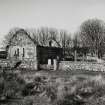
The restored, roofless shell of the former parish church, known locally as Kildalton Chapel, is as described by previous authorities. The font and piscina have been removed, but immediately outside the north doorway is a partially buried stone, 0.7m by 0.6m containing a slightly-oval depression 0.3m across and 0.15m deep. This was probably a font or holy water stoup.
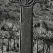
Kildalton High Cross (DOE nameplate) as described is now under guardianship. The present whereabouts of the cup-marked stone, formerly at its base, cannot be ascertained. The graveyard is still used infrequently.
The Thieves Cross (local name) is protected by an iron railing.
Surveyed at 1:10 000.
Visited by OS (NKB), 20 March 1979.
Desk Based Assessment (1979)
NR45SE 3.00 45804 50818
(NR 4580 5080) Chapel (NR) (In ruins)
Burial Ground (NR) (NR 4580 5081)
OS 6" map (1900)
NR45SE 3.01 NR 4580 5080 Kildalton Manse
NR45SE 3.02 NR 45835 50867 Stone Crosses (Small cross outside burial ground)
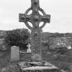
NR45SE 3.03 NR 45802 50830 Great Cross (The Kildalton Cross)
The remains of the former parish church of Kildalton, dedicated to St John the Evangelist and presumably used until the modern parish church was built at NR 39 45 in 1730. It measures 56 1/2ft by 20ft and its 3ft thick walls are of peculiar construction, the side walls being composed of ten courses of large roughly shaped stones with smaller stones between. There are doors in both the north and south walls and two pointed windows in the east. There are also round-headed windows at the east end of the north and south walls as well as a small one high up in the west gable.
All the openings were faced with white sandstone. Internally sockets for a chancel screen are visible as are traces of plaster on the walls. The piscina and font still survive.
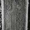
Although the church has a Medieval dedication, the name Kildalton, although its exact derivation is not known, suggests an early foundation and this is confirmed by the existence at NR 4580 5083 in the burial ground of a very fine high cross, probably dating from about 800 AD. Carved from a single block of local blue-stone, it is a free-standing, Celtic ring-cores, 9ft high whose ornament consists of panels with interlacing, zoomorphs and biblical motifs, carved in relief. The SE corner of its basal flagstone formerly bore a 'cup-mark', 6ins in both diameter and depth, with a pestel, which were associated with superstituous rites, as at Kilchoman NR26SW). It was broken off and removed between 1900 and 1910. The cross has been stabilised by the construction of a flight of steps.
Other carved stones from the site cover the period from the 10th to the 18th centuries and a presumably associated Medieval cross stands 50 yds NE of the churchyard at NR 4583 5086. It stands on a cairn base and is sometimes referred to as "The Thief's Cross'. It is a fine example of the geometrically patterned head type with a plain shaft except for roll-moulding at each edge. The chapel has recently been restored by the Islay Historical Works Group.
Orig Paroch Scot 1854; R C Graham 1895; J R Allen and J Anderson 1903; W D Lamont 1972; E MacKie 1976; information from R W B Morris typescript, 1968.
Information from OS.
Field Visit (June 1982)
This church stands within its graveyard, in the SE corner of Islay and 1 km W of the nearest boat-landing at Port Mor.
The ground immediately to the S and E is broken by a series of low rocky ridges, while to the NW it slopes to a level valley-bottom which before the period of agricultural improvement was probably a marsh. Although the churchyard contains one of the Finest Early Christian crosses in Britain, suggesting a close connection with lona, there is no evidence of a vallum or other remains of monastic character. Slight traces of a subrectangular building close to the road N of the church (IASG (7),36) do not appear to be of any great antiquity. The present churchyard wall is of 19th-century date, and there are no remains of an earlier enclosure.
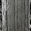
The church is a plain oblong building measuring 17.3m from E to W bv 5.7m transversely within walls some 0.9m in thickness. The masonry is of regular flattish boulders roughly brought to courses and bonded with numerous small pinnings laid in coarse lime mortar. The original quoins and dressings are composed of orange-speckled buff-coloured sandstone which can be matched with specimens of Old Red Sandstone from the Machrihanish area of Kintyre. Many of these stones were robbed and subsequently, probably in the early 20th century, replaced by concrete, while many of the dressings were renewed, using cream-coloured sandstone from the North of England, when the building was repaired in 1973-4. It is roofless, but the walls and gables stand for the most part to their full height, and a sandstone skew is preserved in situ at the N side of the E gable. The building is now unicameral but it is probable that in the original arrangement the interior was subdivided by a timber screen placed about one-third of the way along its length. The smaller, or eastward division of the building, comprising the chancel, was lit by a pair of single-light windows in each of the side-walls and by twin lancets in the E
gable. All these windows have been to some extent mutilated, and subsequently restored in rubble and concrete, but it is clear that in the original arrangement they had sloping sills and deeply-splayed round-arched embrasures with dressed sandstone margins. Above the arch-heads there are rubble relieving-arches. The embrasures vary in size, the two S windows being rather taller than the N ones, and their daylight openings correspondingly larger. The twin lancets are taller than the-other windows and their sills are set at a slightly higher level. All the windows appear to have had rebated daylight openings about 0.23m in width, and the outer surrounds were wrought with a very shallow chamfer, but some of these mouldings have been inaccurately renewed. The windows in the side-walls were semicircular-headed and had monolithic heads, now cracked and in one case renewed, but the heads of the twin lancets appear to have been formed by pairs of stones shaped to the curve and bedded with vertical joints. At the E end of the S wall there are the remains of a projecting piscina surmounted by a canopy, while at the N end of the E wall there may be seen an aurnbry having a slab-lintel and round-arrised jambs of freestone. It is evident from the position of these features in relation to the existing ground-level, that the original floor of the E portion of the church lies at least 0.6m beneath the present surface.
The larger, or western division of the interior, constituting the nave, contains two original entrance-doorways placed almost opposite to one another in the N and S walls. Both doorways were provided with draw-bars and both evidently incorporated splayed round-arched embrasures with dressed sandstone margins. The embrasure of the N doorway is provided with inner and outer relieving-arches. The margins of both openings have been badly robbed, so that it is now impossible to determine the precise forms of the doorways. The N doorway, however, was probably round-arched externally and the jambs appear to have been wrought with a plain rounded arris. The S doorway was loftier than its neighbour, but both openings appear to have measured about 0.9m in width.
The only window lighting the nave is a much restored single-light opening centrally placed in the upper portion of the W gable. None of the external dressings of the window now remain in situ, but internally there may be seen a splayed embrasure having freestone margins wrought with a quirked edge-roll moulding. In the original arrangement the church was probably covered with an open timber roof, but the position of the remaining plaster coating of the W gable suggests that this end of the building may latterly have been ceiled at the level of the main wall-head. The existing ground-level at the W end of the church appears to be only a few centimetres above that of the original floor.
This church served the medieval parish of Kildalton, an independent parsonage in the patronage of the Bishops of the Isles, and although the earliest documentary record dates from 1425,2 the architectural characteristics of the building indicate that it was erected in the late 12th or early 13th century. The name Kildalton (Cill Daltan) incorporates a diminutive form of the Irish dalta, a 'foster-child' or 'disciple', and the dedication in medieval sources was to St
John the Evangelist.3* Despite a proposal in 1651 to transfer public worship to Kilbride (RCAHMS 1984, No. 363), the building apparently remained in use until about the end of the 17th century, when services were transferred to a more convenient site at Lagavulin.** At the end of the 18th century it was reported that the walls were still intact but that the roof had been demolished 'many years ago'.' Repairs were made to the fabric in about 1925, and further work was undertaken by the Islay Historic Works Group in 1973-4.
Funerary Monuments, Crosses and other Carved Stones:
Early Christian. Number 1 stands in the churchyard, about 8m N of the chancel. Number 5 is inside the church, number 2 at the National Museum of Antiquities of Scotland, and numbers 3 and 4 at the Museum of Islay Life, Port Charlotte.
(1) The Kildalton Cross see NR45SE 3.03
(2) (NR45SE 3.04)
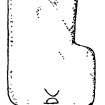
Thin slab of epidiorite, 0.70m in length by 0.19m in maximum width, pointed at the foot. It bears an incised outline cross whose arms are set at the mid-point of the shaft.The end of the left arm is open, possibly as the result of damage to the edge. This stone was found in 1882, face downwards, immediately below the SW corner of the socket-stone of the Kildalton Cross, number 1; below it were water-worn pebbles covering human bones. By virtue of its shape this slab would have made a convenient wedge for levelling the cross-base, and it must remain doubtful whether it was originally associated with the burial. (NMAS cast IB4, on loan to Museum of Islay Life, Port Charlotte; Proc Scot Antiq Scot, 1883 and 1922-3; Graham, 1895; Lament, 1968).
(3) (NR45SE 3.05) Roughly rectangular slab of epidiorite, 0.85m by 0.45m in maximum dimensions; the surface of the lower part has split off. It bears an outline incised Latin cross with rounded armpits, incomplete at the foot.
(4) (NR45SE 3.06) Thin roughly rectangular slab of schistose epidiorite, 0.61m by 0.34m in maximum dimensions; incomplete at the foot. It bears a ringed outline cross with rounded sunken armpits and a long shaft.
(5) (NR45SE 3.07) L-shaped slab of epidiorite, 0.90m by 0.50m in maximum dimensions. It appears to have been part of a cross-base, and incorporates traces of a socket 0.41m wide. Although it is possible that this slab is of medieval date, it may formerly have been associated with the Kildalton Cross, whose width matches that of the socket.
Medieval
Numbers 7, 9, 10, 13, 14, 16-18, 20 and 21 are inside the church, numbers 6, 11, 12, 15 and 19 in the churchyard, and number 8 stands on what is presumably its original site some 50m NE of the church. Of the group of stones described under number 23, some lie outside the W wall of the church, while others are incorporated in the threshold of the S door, or reused as grave-markers in the churchyard. Number 22 could not be identified at the date of
visit.
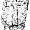
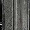
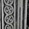
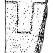
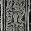
(6) Tapered slab, 1.61m by 0.40m, bordered by a single roll-moulding, exceptionally well preserved. At the top there is a foliated cross on a long central shaft which rises from a semicircular foliated base. To the right of the shaft is a single-hand sword with lobated pommel and inclined quillons slightly expanded at the ends, the blade having a central fuller. Below the sword is a small circular disc bearing traces of spiral ornament. To the left is a plant scroll incorporating demi-palmette and trefoil leaves, and ending at the top in a dragon's head. (Graham, 1895). lona school, 14th century.
(7) Lower part of a tapered slab, 1.0m in length by 0.44m in maximum width, bordered by a single roll-moulding; now similar to that on number 6, and flanked by plant-scroll lona school, 14th century.
(8) Free-standing disc-headed cross with splayed arms erected on an artificial stony mound enclosed by a ditch height, the diameter of the disc-head 0.40m and the span the arms 0.75m; the shaft tapers from 0.28m by 0.15m at ground level to 0.23m by 0.12m at the neck. Each face bordered by a roll-moulding, the shaft and edges being undecorated. The ornament of the E face of the cross-head comprises a cross with round armpits and a small centralboss, interlaced with two concentric circles and terminating in the upper and side-arms in ring-knots. The W face bears more intricate plaitwork cross with central boss and foliate terminals incorporating in the left arm a saltire and in the upper arm a Latin cross. " (Stuart 1867; Graham, 1895, shows E face only), lona school, 14th-15th century.
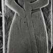
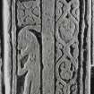
(9) Tapered slab, 1.94m by 0.73 m, bordered by a trip moulding and bearing the effigy of a man in armour; built into the recess of the E window in the S wall of the church. The figure wears a conical bascinet, an aventail or coif of mail and a knee-length aketon with elbow-straps. There are also bands round the ankles, presumably spurs. A weeper carved in relief in a cusped round-headed niche to the right the figure's head, and a hound below his left elbow, while to the left of his head there is an inscription in Lombardic capitals:
+ HIC IAC/ET IMAR
'Here lies Imar'.
(Steer and Bannerman 1977; Graham, 1895). lona school, 14th-15th century.
(10) Tapered slab borderd by a roll-moulding, 1.86m by 0.52m; it is broken across, and much of the surface has flaked off. At the top there is an intricate design incorporating ?four dragons with their long necks intertwined, then a central sword with lobated pommel and inclined quillons, flanked by coarse plant-scrolls. At the foot of the slab there is a casket. Loch Awe school, 14th-15 century.
(11) Tapered slab, bordered by a double roll-moulding 1.88m by 0.48m. At the top there is a diagonal plaitwork cross incorporating rings at the centre and terminal followed by a central sword having a round pommel with tang-button, inclined quillons expanded at the ends, and scabbard-chape." To the right of the sword-hilt there is animal whose tail is linked to a double plant-stem flanking the blade, while to the left is a worn scene, possibly a seated figure holding a harp surmounted by a ?bird (cf. No. 386, 11) Below the left quillon is a foliated saltire cross, followed by a grotesque creature from whose head there emerges a ?horn of liripipe, 'o* and then a plant-stem. At the foot of the slab is a pair of shears. (NMAS cast IB 138; PSAS, 1883 ; Graham, 1895). Loch Sween schot right a chalice with a paten above it. 14th-early 16th century.
(18) Tapered slab, 1.65m by 0.44m. It is broken across and much worn, the only visible decoration being a foliated cross at the top. (Graham, 1895), 14th-early 16th century.
(19) Tapered slab of local epidiorite, 1.53m by 0.42m; much worn. The only visible decoration is a foliated cross at the top. 14th-early 16th century.
(20) Tapered slab of local epidiorite, 1.70m by 0.49m, bordered by a roll-moulding. It is broken across, and apart from foliage and traces of a ?gabled niche at the top the decoration has flaked away. There is now no trace of the secondary date 1716 mentioned by Graham. (Graham, 1895). 14th-early 16th century.
(21) Rectangular slab, 1.81m by 0.56m; the bottom right corner is broken off. It bears the low-relief effigy of a man wearing a bascinet, aventail and knee-length aketon. Suspended at his waist there is a single-hand sword with the round pommel and long tang-button of the claymore, but slightly inclined quillons. The figure's head rests on a pillow, and below his feet there has been the hull of a galley, of which only the stern remains. A black-letter inscription, which runs along the top and continues onto the right margin, reads:
(Hie] lACET [. . . . .] ALANI [s]ORLETI/MA[c)CEAIN
'Here lies...... son of Alan. son of Somerled Maclan'.
It is possible that this effigy commemorates a grandson of Somerled, son of John Maclan ofArdnamurchan, who was
killed about 1500. In design and execution it shows similarities to the work of the Oronsay school, but it is
probably of local manufacture. (Steer and Bannerman 1977; Graham, 1895) c.1500-1560.
(22) Graham describes a slab bearing 'a rudely carved wheel ornament' and a secondary inscription HEW MCLEOD 1716, with a crowned heart. (Graham, 1895).
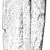
(23) A group of at least eight carefully dressed slabs of chlorite-schist. All are similar in cross-section, measuring 0.55m in width by about 90mm in thickness and having rebates 60mm wide at the axial sides of the lower faces. Three of the slabs, which are intact and measure respectively 0.32m, 0.33m and 0.75m in length, display a 20mm chamfer at one transverse end, and a rebate on the lower face at the other end, while some of the incomplete slabs bear similar chamfers, or have vertical transverse edges. The total length of the extant slabs exceeds 3.6m. One, which is in secondary use as a grave-marker, bears the inscription 1766 A M D, and the slabs are probably of late medieval date, but their purpose is uncertain. Although they may have been incorporated in tomb-chests or cross-bases, structural members to provide the necessary stability are lacking.
Post-Reformation.
Numbers 24 and 26 are in the church, numbers 25 and 27 in the churchyard, and number 28 in the Campbell of Ardmore burial-enclosure SW of the church.
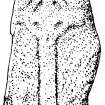
(24) (NR45SE 3.08)Tapered slab of local epidiorite, 1.70m by 0.50m; part of the upper edge has flaked off. The only decoration is a crude Latin cross in relief. Although this stone could be earlier, it is probably of post-Reformation date. (Lamont 1868).
(25) Recumbent slab of epidiorite, plain except for a centrally-placed flat-topped boss 120mm in diameter in the upper half.
(26) Tapered slab of epidiorite, 1.9m by about 0.6m; the right edge is damaged in places. Incised at the centre is a sporting gun with a curved and fluted stock, (The Commissioners are indebted to Dr D H Caldwell, National Museum of Antiquities of Scotland, for the information that this is a late 17th century Scottish long gun with snaphance lock, of a type made in the Highlands and NE Scotland) flanked by a powder-horn and a hound.
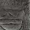
The marginal inscription reads:
HE[A]R LYES CHARGES] / MCARTHOR WHO LIVED IN PROAIK
(Proaig)
AND DEPARTED/THIS LIFE THE/FIFTEN DAY OF FEBRVAREY
1696 YEARES
(Graham,1895).
(27) Tapered slab of chlorite-schist, 1.62m by 0.45m. It is bordered by a double moulding whose broad inner member is mitred at the angles; although this margin may be earlier than the remaining decoration, it is not of medieval character. At the centre there is incised a sword with ribbed hand-grip, curved quillons and a continuous knuckle-guard, and above it a shield bears the inscription: l716/IS FECE/T (sic for fecit, 'made'). An inscription incised within the margin of the central panel commemorates James, son of James Steward, who died in 1716.
(28) Round-topped headstone erected in 1770 to mark their family burial-place by Alexander Campbell of Ardmore, his son John Campbell of 'Kenture' (Kintour), and his brother Archibald Campbell of Trudernish.
RCAHMS 1984, visited June 1982.
Publication Account (1985)
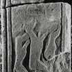
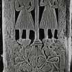
The simple church dating to the late 12th or early 13th century is an oblong building, now heavily restored, although some interior features including the remains of a piscina and an aumbry may still be seen. What is remarkable about Kildalton is the presence of one of the most complete Early Christian crosses still to be found in Scotland, dating to the second half of the eighth century. The decoration is clearly comparable to the crosses on Iona and demonstrates that this part of the Dalriadan possessions was within a similar artistic ambit The ringed cross has been carved from a single slab of epidiorite. At the top of the shaft on the east face there is a representation of the Virgin and Child flanked by angels; on the arms of the cross the scenes have most recently been identified as Cain's murder of Abel, and Abraham's sacrifice of Isaac, while at the centre of the upper shaft of the cross it is possible that, surmounted by a pair of angels, the carvers have shown David slaying the lion. The remaining ore decorative panels on this side demonstrate the carvers' expertise in serpent-and-boss ornament and in curvilinear interlace. On the west side serpent-and-boss patterns run in restrained riot creating a three-dimensional decoration, with four lions around the central boss.
There are at least seventeen West Highland graveslabs both inside the church and in the surrounding graveyard which underline the importance of Kildalton from Early Christian times to the medieval period, when the present parish church was built The slabs are of diverse manufacture and belong to four of the five schools of carving outlined by Steer and Bannerman, Iona, Loch Awe, Loch Sween and Oronsay.
Information from ‘Exploring Scotland’s Heritage: Argyll and the Western Isles’, (1985).
Reference (2001)
Slab (2) is in the collection of the National Museums of Scotland (NMS X.IB 193). (Slabs (3) and (4) are now at the Museum of Islay Life.
I Fisher 2001.
Field Visit (18 March 2017 - 19 March 2017)
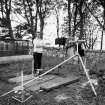
NR 45804 50830 (NR45SE 3) A series of survey techniques were deployed, 18–19 March 2017, to update the existing record for Kildalton Chapel and burial ground as part of a broader research and conservation programme initiated by Islay Heritage, which also included a 3D virtual interactive model of the 13th-century chapel researched and produced by Archaeovision – http://islayheritage.org/kildalton-chapel/
The electrical resistance survey was carried out using a Geoscan RM15 resistance meter and the readings were taken at 0.5m intervals along the traverses with 0.5m spacing. Topographic survey and mapping of the burial ground was carried out using a Leica GS09 GPS rover. Terrestrial 3D laser survey of the chapel was carried out by Aiji Castle of Topcon using a Topcon GLS-2000 laser scanner.
The electrical resistance survey of the burial ground and the chapel interior produced a complex geophysical plot, which is not easy to interpret. Survey of the above-ground burial stones and plots helped to elucidate some of the linear bands of high and low resistance in the W part of the burial ground as the lines of burials. Several larger high resistance
anomalies present closer to the chapel, especially to the S and N, may correspond to further burial activity or possibly structures.
Archive and report: NRHE
Funder: Ian Mactaggart Trust
Darko Maricevic, Alexandra Knox, Robert Fry, Sarah Lambert-Gates, Aiji Castle and Steven Mithen – Islay Heritage
(Source: DES, Volume 18)
OASIS ID: universi22-285817
Project (25 March 2017 - 1 April 2017)
NR 45804 50830 A geophysical and walkover survey of the environs of the 8th-century Kildalton High Cross was undertaken, 25 March – 1 April 2017, by a group of University of Glasgow archaeologists. The survey did not find any clear evidence of an early Christian vallum or any feature which may relate to pre-existing structures immediately outside the churchyard of Kildalton. The churchyard was found to have rig and furrow cultivation in the suitable flat ground around it, which may have removed any trace of earlier features. The area immediately W of the churchyard enclosure is subsumed under a raft of field clearance and it is recommended that this area be cleared and evaluated with trial trenching to test the integrity of the archaeological deposit.
Geophysical survey using both earth resistance and gradiometry techniques in the Lon an t-Sagairt field to the N revealed possible linear features and an apparent rectilinear enclosure, but these did not appear to relate to the church site above. Walkover survey identified part of the main rampart of the hillfort at Creagan na Ceardaich Mor to the N of the church, along with an upstanding rectilinear banked structure at its lower slope. These stone and turf-defined features and a single 20 x 10m area of the hillfort summit were surveyed with resistivity but proved inconclusive due to field clearance and heavy overgrowth of vegetation. It is recommended that the hillfort and banked structures at its foot be cleared and properly recorded with the aim of identifying possible dating by morphology.
Finally, preliminary photogrammetric models were created from the Kildalton High Cross and the adjacent Thief’s Cross by Heather Christie which raise new questions about the monuments and their setting; these are now available to view online via Sketchfab. The cairn of the Thief’s Cross is set within a peculiar ring ditch with outer bank, which is shown to be sub-square in form by the digital model; it is possible that this medieval cross is set atop a reused ancient burial monument but only excavation may shed more light. It is recommended that a full photogrammetric survey of the early and late medieval stones be carried out for conservation
purposes.
Archive: NRHE
Funder: Historic Environment Scotland
Adrian Maldonado – University of Glasgow
(Source: DES, Volume 18)
OASIS ID: universi22-285817
Resistivity (25 March 2017 - 1 April 2017)
NR 45804 50830 A resistance survey of the environs of the 8th-century Kildalton High Cross was undertaken, 25 March – 1 April 2017, by a group of University of Glasgow archaeologists.
Archive: NRHE
Funder: Historic Environment Scotland
Adrian Maldonado – University of Glasgow
(Source: DES, Volume 18)
OASIS ID: universi22-285817
Magnetometry (25 March 2017 - 1 April 2017)
NR 45804 50830 A gradiometry survey of the environs of the 8th-century Kildalton High Cross was undertaken, 25 March – 1 April 2017, by a group of University of Glasgow archaeologists.
Archive: NRHE
Funder: Historic Environment Scotland
Adrian Maldonado – University of Glasgow
(Source: DES, Volume 18)
OASIS ID: universi22-285817

