|
Photographs and Off-line Digital Images |
B 36959 P |
Records of the Royal Commission on the Ancient and Historical Monuments of Scotland (RCAHMS), Edinbu |
Loch Allallaidh, Islay.
Photographic copy of plan of fortified island.
Pen and ink. |
c. 1980 |
Item Level |
|
|
Prints and Drawings |
AGD 819/2 |
Records of the Royal Commission on the Ancient and Historical Monuments of Scotland (RCAHMS), Edinbu |
Loch Allallaidh, Islay.
Plan of fortified island. |
1982 |
Item Level |
|
 |
On-line Digital Images |
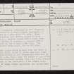
SC 2414904 |
Records of the Ordnance Survey, Southampton, Hampshire, England |
Islay, Loch Allallaidh, NR45NW 2, Ordnance Survey index card, page number 1, Recto |
1958 |
Item Level |
|
 |
On-line Digital Images |
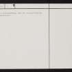
SC 2414905 |
Records of the Ordnance Survey, Southampton, Hampshire, England |
Islay, Loch Allallaidh, NR45NW 2, Ordnance Survey index card, page number 2, Verso |
1958 |
Item Level |
|
|
All Other |
551 166/1/1 |
Records of the Ordnance Survey, Southampton, Hampshire, England |
Archaeological site card index ('495' cards) |
1947 |
Sub-Group Level |
|


