
Scheduled Maintenance
Please be advised that this website will undergo scheduled maintenance on the following dates: •
Tuesday 3rd December 11:00-15:00
During these times, some services may be temporarily unavailable. We apologise for any inconvenience this may cause.
Unst, Blue Mull


Monastery (Period Unassigned)(Possible), Structure(S) (Period Unassigned)
Site Name Unst, Blue Mull
Classification Monastery (Period Unassigned)(Possible), Structure(S) (Period Unassigned)
Canmore ID 38
Site Number HP50SE 19
NGR HP 55832 04234
Datum OSGB36 - NGR
Permalink http://canmore.org.uk/site/38


- Council Shetland Islands
- Parish Unst
- Former Region Shetland Islands Area
- Former District Shetland
- Former County Shetland
HP50SE 19 5580 0425
(HP 558 043) Traces of a rampart occur on the upper side of the declivity which runs from Freckles Geo (HP 558 045) to Lamba Geo (HP 558 041). Two small, irregularly-shaped, turf enclosures lie at the foot of the declivity, one on either side of the east track which ascends it. Rampart and enclosures may be comparatively modern.
RCAHMS 1946, visited 1930.
At HP 5580 0425 on the exposed S end of the Blue Mull between the wall described by the RCAHMS and sheer cliffs, about 200 feet high, are the turf-covered footings of seven sub-rectangular buildings, grouped together. Oriented E-W they vary from 7.0m by 4.5m, to 4.5m by 3.5m, with entrances in the E. No stones are visible, and it may be assumed they were built of turf. Possibly a monastic settlement similar to Brough of Deerness, Orkney (HY50NE 14).
The so-called rampart described by the RCAHMS is 0.5m high and spread to 2.0m, and follows the top edge of a steep natural slope which isolates the headland. It is unlikely to be defensive and was probably built comparatively recently to form a sheep pound on the headland, a typical Shetland feature, although it could be associated with the group of huts. The 'enclosures' mentioned by the RCAHMS are probably two grassy platforms at the foot of the slope - purpose unknown.
Surveyed at 1/10,000.
Visited by OS (NKB) 5 May 1969.
Note (11 November 2015 - 13 December 2016)
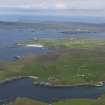
The Blue Mull lies at the N end of the sound separating the islands of Unst and Yell, forming the large headland on the E side of its mouth. The headland rises out of a gully formed along a geological faultline lying obliquely N and S across its neck, creating a natural enclosure which expands NNW from a sharp angle where the gully cuts through to the coastal cliffs on the W. Here the footings of a cluster of seven sub-rectangular buildings are visible, while the remains of a bank or wall can be traced along the lip of the gully for a distance of 280m, cutting off an area measuring some 350m in length by up to 325m in breadth on the NNW above the rocky coastal edge (8.2ha). While the cluster of buildings has been interpreted as a probable Norse monastic site (Lamb 1973, 78, 84, 85; 1976, 145, 152), most investigators have considered the enclosure to be a more recent agricultural dyke (RCAHMS 1946, 140, no.1576), though this has yet to be demonstrated by excavation, or indeed whether an earlier perimeter lies beneath the visible bank. There is certainly evidence of later activity on the headland, demonstrated by the old lime kiln marked on the 1st edition OS 6-inch map at the seaward end (HP 5577 0464; Shetland 1882, sheet 5), the traces of peat cuttings all over its raised central spine, and perhaps including the track that ascends the W side of the gully about 100m from the S tip of the enclosure bank. The only other features noted within the interior are two low mounds observed in 1930 by RCAHMS investigators, though in 1969 the OS surveyor was unable to locate them.
Information from An Atlas of Hillforts of Great Britain and Ireland – 13 December 2016. Atlas of Hillforts SC3723

