
Colonsay, Dun Cholla


Fort (Later Prehistoric)
Site Name Colonsay, Dun Cholla
Classification Fort (Later Prehistoric)
Canmore ID 37885
Site Number NR39SE 12
NGR NR 37770 91520
Datum OSGB36 - NGR
Permalink http://canmore.org.uk/site/37885


- Council Argyll And Bute
- Parish Colonsay And Oronsay
- Former Region Strathclyde
- Former District Argyll And Bute
- Former County Argyll
NR39SE 12 3777 9152.
(NR 3775 9150) Dun Cholla (NR) (Site of)
OS 6" map (1900)
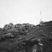
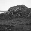
A fort measuring 200' NE-SW by 80' within a wall over 10' thick. The entrance 5' wide, is in the east, the only accessible side, the others being preciptous cliff. There are traces of outworks on the NE and much debris lies about the slopes.
At the NW end of the interior is a stone-walled hut foundation 25' across with a concentric ring of internal post holes as well as a central post hole. On the mainland such a structure would be dated to the first few centuries AD. The whole interior is uneven with outcropping rock but there are traces of a wall forming a small enclosure in the SE corner.
S Piggott and C M Piggott 1948; R W Feachem 1963
NR 3775 9152 The fort is generally as described and measures 60.0m EW by 24.0m. The wall on the E is 4.0m thick and three courses high. The outer face is still visible on the N and NW while on the S and SW only a line of rubble remains. Within the fort are the foundations of two circular huts one measuring 7.5m in diameter whilst the other is incomplete but probably measured about 8.0m in diameter. There are no traces of outworks to the NE.
Surveyed at 1/2500.
Visited by OS (BS) 11 April 1974
Measured Survey (1975)
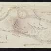
RCAHMS surveyed the fort at Dun Cholla using plane-table and alidade at a scale of 1:400. The resultant plan was redrawn in ink and published at a reduced scale (RCAHMS 1984, fig. 89A).
Field Visit (June 1976)
NR 377 915. This fort occupies the s end of a rocky promontory about 800m WNW of Balerominmore farmhouse. The S and W sides are protected by sheer cliffs, but from the NE the approach is up a gentle grass-covered slope.
The fort is defended by a single wall which encloses an area measuring 54m by a maximum of 25m. On the NE, where there is least natural protection, the wall is up to 6m thick, and the outer facing-stones, which are unusually large and well coursed, stand to a height of 1.25m in four courses; elsewhere the wall is about 2.5m thick. Immediately SE of the entrance there is a short stretch of medial walling, probably designed to reinforce the greater wall-thickness in this sector, and on the NW the lowest course of the outer face is founded on a revetted platform in order to give it greator stability. The entrance, which lies on the NE, was modified in antiquity.
Originally it measured 1.8m in width at its outer end and was checked on the s at a point 1.8m from the outside. Later the passage was reduced to a width of 1.4m by adding an extra skin of stone to the S side, and a new check was built 2.9m from the outer end; at the same time the lowest course of the outer face was continued across the entrance, partially blocking the passage. In the interior there are the footings of two enclosures and a stretch of ruined wall, all of which are of comparatively recent date.
RCAHMS 1984, visited June 1976
Excavation (2013)
NR 3777 9152 Test excavations were undertaken at a ‘house’ platform below Dun Cholla over a three day period during Easter 2013. This project was part of a broader island wide survey of the historical landscape of Colonsay, funded by the AHRC as part of its Heritage Research for Communities programme, and involved the University of Ulster, Queen’s University Belfast, Kilmartin House Museum, Historic Scotland and The National Trust for Scotland working with the local community to investigate their historic past.
This site consists of a sub-rectangular earthwork measuring 13m long and 9.5m wide. It contains an internal area of c50m2 and appears to have two opposing entrances in the N and S wall respectively. An external ditch, possibly associated with drainage is located at the W gable. No other structural features are apparent but a set of lazy beds or cultivation ridges are present S of the site. A 2 x 4.5m trench was excavated inside the structure immediately E of the entrance features. A number of primary phases of activity were noted. A small shallow bowl furnace was located and predated the later construction of the house. The house was late medieval in character and finds included an early 17th-century gun flint. The house was probably abandoned by the early part of the 18th century.
Archive: University of Ulster
Funder: Arts and Humanities Research Council
Colin Breen, University of Ulster, 2013
(Source: DES)
Note (2 October 2014 - 2 August 2016)
This fort occupies a strong position with precipitous rock faces on the S and W and measures about 54m from ENE to WSW by 25m transversely (0.13ha) within a single stone wall. At the more accessible ENE end, to either side of the entrance, the wall is up to 6m in thickness, with an outer face of large blocks standing 1.25m high in four courses, but elsewhere around the margin of the summit it is no more than 2.5m thick. The entrance has evidently been modified, and an original plan in which it was 1.8m in width at the outer end, with checks 1.8m from the outer face, has been reduced to a width of 1.4m, with a new check 2.9m from the outer face. This reconstruction possibly accounts for the medial wall face visible in the thickness of the wall to the SE of the entrance, though equally this may belong to some internal structure of the wall, to which end on the NW the outer face is founded on a built platform. The footings of two later enclosures and a length of wall can be seen within the interior.
Information from An Atlas of Hillforts of Great Britain and Ireland – 02 August 2016. Atlas of Hillforts SC2164

