|
Photographs and Off-line Digital Images |
B 36803 P |
Records of the Royal Commission on the Ancient and Historical Monuments of Scotland (RCAHMS), Edinbu |
Colonsay, Loch an Sgoltaire.
Photographic copy of fortification plan. |
c. 1978 |
Item Level |
|
|
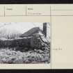
Photographs and Off-line Digital Images |
AG 11400 |
Records of the Royal Commission on the Ancient and Historical Monuments of Scotland (RCAHMS), Edinbu |
Colonsay, Loch an Sgoltaire.
General view from East. |
1980 |
Item Level |
|
|
Photographs and Off-line Digital Images |
AG 11401 |
Records of the Royal Commission on the Ancient and Historical Monuments of Scotland (RCAHMS), Edinbu |
Colonsay, Loch an Sgoltaire.
General view from South-East. |
1980 |
Item Level |
|
|
Prints and Drawings |
AGD 984/1 |
Records of the Royal Commission on the Ancient and Historical Monuments of Scotland (RCAHMS), Edinbu |
Colonsay, Loch an Sgoltaire.
Plan of site. |
1978 |
Item Level |
|
|
Prints and Drawings |
AGD 984/2 |
Records of the Royal Commission on the Ancient and Historical Monuments of Scotland (RCAHMS), Edinbu |
Colonsay, Loch an Sgoltaire.
Plan of site. |
1978 |
Item Level |
|
|
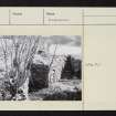
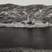
Photographs and Off-line Digital Images |
AG 2537 |
|
Colonsay, Loch an Sgoltaire.
General view. |
5/1962 |
Item Level |
|
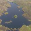 |
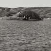
On-line Digital Images |
DP 095485 |
RCAHMS Aerial Photography Digital |
Oblique aerial view of Loch an Sgoltaire and the castle, taken from the SSE. |
1/9/2010 |
Item Level |
|
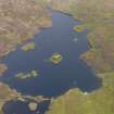 |
On-line Digital Images |
DP 095486 |
RCAHMS Aerial Photography Digital |
Oblique aerial view of Loch an Sgoltaire and the castle, taken from the SE. |
1/9/2010 |
Item Level |
|
 |
On-line Digital Images |
SC 2414512 |
Records of the Ordnance Survey, Southampton, Hampshire, England |
Colonsay, Loch An Sgoltaire, NR39NE 5, Ordnance Survey index card, Recto |
1958 |
Item Level |
|
 |
On-line Digital Images |
SC 2414513 |
Records of the Ordnance Survey, Southampton, Hampshire, England |
Colonsay, Loch An Sgoltaire, NR39NE 5, Ordnance Survey index card, page number 1, Recto |
1958 |
Item Level |
|
 |
On-line Digital Images |
SC 2414514 |
Records of the Ordnance Survey, Southampton, Hampshire, England |
Colonsay, Loch An Sgoltaire, NR39NE 5, Ordnance Survey index card, page number 2, Verso |
1958 |
Item Level |
|
 |
On-line Digital Images |
SC 2414515 |
Records of the Ordnance Survey, Southampton, Hampshire, England |
Colonsay, Loch An Sgoltaire, NR39NE 5, Ordnance Survey index card, page number 1, Recto |
1958 |
Item Level |
|
 |
On-line Digital Images |
SC 2414516 |
Records of the Ordnance Survey, Southampton, Hampshire, England |
Colonsay, Loch An Sgoltaire, NR39NE 5, Ordnance Survey index card, page number 2, Recto |
1958 |
Item Level |
|
 |
On-line Digital Images |
SC 2601027 |
Records of the Royal Commission on the Ancient and Historical Monuments of Scotland (RCAHMS), Edinbu |
Colonsay, Loch an Sgoltaire.
General view from East. |
1980 |
Item Level |
|
 |
On-line Digital Images |
SC 2601028 |
Records of the Royal Commission on the Ancient and Historical Monuments of Scotland (RCAHMS), Edinbu |
Colonsay, Loch an Sgoltaire.
General view from South-East. |
1980 |
Item Level |
|
|
All Other |
551 166/1/1 |
Records of the Ordnance Survey, Southampton, Hampshire, England |
Archaeological site card index ('495' cards) |
1947 |
Sub-Group Level |
|


