|
Prints and Drawings |
DC 40 |
Records of the Royal Commission on the Ancient and Historical Monuments of Scotland (RCAHMS), Edinbu |
Topographical map of islands Jura, Islay, Colonsay, Oronsay.
Inv.p.1. RCAHMS Copy in library.
(Currently missing - 31/5/96) |
|
Item Level |
|
|
Prints and Drawings |
DC 44 |
Records of the Royal Commission on the Ancient and Historical Monuments of Scotland (RCAHMS), Edinbu |
Distribution map of hut circles, field systems, settlement and burnt mounds.
Inv p.12 RCAHMS. Copy in library. |
1984 |
Item Level |
|
|
Prints and Drawings |
DC 348 |
Records of the Royal Commission on the Ancient and Historical Monuments of Scotland (RCAHMS), Edinbu |
Plan of hut-circle 1:400 RCAHMS Plan of enclosures 1:200 RCAHMS 1980 Plan of Complex 1:1000 RCAHMS 1980 |
1980 |
Item Level |
|
|
Photographs and Off-line Digital Images |
DC 349 P |
Records of the Royal Commission on the Ancient and Historical Monuments of Scotland (RCAHMS), Edinbu |
Plan ink 1:1000 RCAHMS Inv. no 247.2 |
|
Item Level |
|
|
Prints and Drawings |
DC 350 |
Records of the Royal Commission on the Ancient and Historical Monuments of Scotland (RCAHMS), Edinbu |
Plan of enclosures 1:200 RCAHMS Plan of site 1:1000 RCAHMS 1980 |
1980 |
Item Level |
|
|
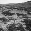
Photographs and Off-line Digital Images |
AG 15274 |
Records of the Royal Commission on the Ancient and Historical Monuments of Scotland (RCAHMS), Edinbu |
RCAHMS |
1983 |
Item Level |
|
 |
On-line Digital Images |
SC 2256146 |
Records of the Royal Commission on the Ancient and Historical Monuments of Scotland (RCAHMS), Edinbu |
RCAHMS |
1983 |
Item Level |
|
 |
On-line Digital Images |
SC 2414359 |
Records of the Ordnance Survey, Southampton, Hampshire, England |
Islay, Bridgend, Borraichill Mor, NR36SW 17, Ordnance Survey index card, page number 1, Recto |
1958 |
Item Level |
|
 |
On-line Digital Images |
SC 2414360 |
Records of the Ordnance Survey, Southampton, Hampshire, England |
Islay, Bridgend, Borraichill Mor, NR36SW 17, Ordnance Survey index card, Recto |
1958 |
Item Level |
|
|
All Other |
551 166/1/1 |
Records of the Ordnance Survey, Southampton, Hampshire, England |
Archaeological site card index ('495' cards) |
1947 |
Sub-Group Level |
|


