
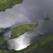
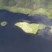
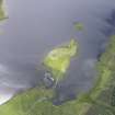
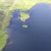
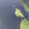
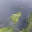
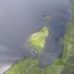
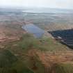
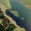
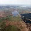
Islay, Loch Finlaggan, Eilean Mor, Chapel


Burial Ground (Medieval), Chapel (Medieval), Cross (Medieval), Cross Base (Medieval), Grave Slab(S) (Medieval)
Site Name Islay, Loch Finlaggan, Eilean Mor, Chapel
Classification Burial Ground (Medieval), Chapel (Medieval), Cross (Medieval), Cross Base (Medieval), Grave Slab(S) (Medieval)
Alternative Name(s) Kilfin Laggan Chapel; Kilfinlaggan Chapel
Canmore ID 37707
Site Number NR36NE 5
NGR NR 38871 68129
Datum OSGB36 - NGR
Permalink http://canmore.org.uk/site/37707


- Council Argyll And Bute
- Parish Killarow And Kilmeny
- Former Region Strathclyde
- Former District Argyll And Bute
- Former County Argyll
NR36NE 5.00 38871 68129
NR36NE 5.01 NR 3886 6812 Stone Basin; Font (Possible)
(NR 38871 68129) Chapel (NR) (In Ruins) Burial Ground (NR)
OS 6" map, Argyllshire, 2nd ed., (1900)
The chapel measure 28ft by 15ft and the walls are more than 3ft thick. The door was in the south wall and there are indications of a double window in the east end. The interior was cleared of fallen masonry in 1894, Grave slabs in the burial ground include one bearing an early 15th century armoured warrior and also fragments of a child's gravestone.
R C Graham 1895.
The chapel was built or restored by John of Islay, Lord of the Isles, who died in 1386. The dedication is to St Finlagan, which name is a diminutive of Findlug (Watson 1926). (No dates given). Presentations were still being made to the chaplainry in 1542, but by 1695 the chapel was in ruins, which would appear to indicate that it did not survive the Reformation. The burial ground, which is now almost obliterated is said to contain the remains of Princess Margaret, daughter of King Robert II (1371-90) as well as the families of the Lords of the Isles. Carved slabs, overgrown by vegetation, lean precariously against the inner walls of the chapel.
Name Book 1878, W J Watson 1926; Orig Parch Scot 1854; M Martin 1698;
T S Muir 1885; F Celoria 1959.
The chapel measuring 8.4 by 4.3m inside a wall 0.8m thick and standing to 3.0m maximum, is as described by Graham (1895) except that the double window is not apparent.
The carved slabs are still in the chapel, but neither gravestones nor a boundary feature remains to indicate the extent of the burial ground. Surveyed at 1:10 000.
Visited by OS (JM), 6 June 1978.
The high ground next to the chapel was excavated. As supposed by the RCAHMS, it turned out to be a graveyard, the most recent (possibly 17th century) burials being characterised by rectangular arrangements of boulders laid flush with the top of shallow burial pits. Stratigraphically the earliest grave encountered was a long cist burial. The feature marked by the RCAHMS as R was indeed the plinth for a free-standing cross. Next to it the head of a 14th or 15th century Iona school cross was found. Its disc-head has splayed arms and is decorated on both faces with plaitwork. Nearby, at the bottom of a steep slope, half a large boulder was found with a socket. It is probably the cross-base.
D Caldwell 1990.
Two small trenches, 14 and 17, within and adjacent to the chapel, were primarily designed to find a floor surface and the extent of collapsed material prior to a scheme of conservation of the upstanding walls proposed by the Finlaggan Trust. It appears that the interior of the building was dug out in the 19th century, removing the medieval floor and disturbing several burials. Some of the bones were gathered up and redeposited in a pit adjacent to the N wall. It is assumed the chapel dates to the 14th century and it was observed that the graveyard deposits extend underneath its foundations.
DH Caldwell 1993.
NR 3887 6812 Rubble and debris were removed from in and around the ruins of the medieval chapel as a preliminary step to conservation of the walls. Previous excavation (Caldwell 1997) and documentary sources had indicated that the interior of the building had been dug over in the late 19th century, destroying floor deposits and disturbing burials. Nevertheless, substantial remains of an altar were found in situ against the E wall. It was 0.9 x 1.55m, with a maximum surviving height of 0.58m above some crude paving, and composed of blocks of stone in a generous mix of lime mortar. Only the bottom course of facing blocks was completely in place, the two front corner stones being of dressed grey-yellow sandstone. Some broken pieces of chlorite schist may be the remains of the altar top.
Other finds include a piece of carved whale bone - possibly part of a crucifix, pieces of dressed sandstone, and a fragment of a carved medieval West Highland grave-slab, probably for a child. A sandstone quoin was uncovered in place at the SE corner. A coin was found embedded in a substantial lump of mortar, well-buried in the rubble against the exterior of the S wall. It is a half-groat, either of David II or Robert II.
Sponsors: National Museums of Scotland, Edinburgh University Officers Training Corps.
D H Caldwell 1998.
PLANS: NMRS measured survey of site by RCAHMS.
Measured Survey (1963 - 1976)
Between 1963 and 1976 RCAHMS produced a series of measured drawings at Castle Finlaggan, including a site plan of Eilean na Comhairle and Eilean Mor as well as detailed plans of buildings A, C and Q (the chapel) all on Eilean Mor. The pencil drawings were redrawn in ink and published at reduced scales (RCAHMS 1984, figs. 33(K), 276, 277B, 278C, 279A).
Field Visit (May 1981)
The best-preserved building among the complex of structures that occupies the NE portion of the island is the chapel (Q) which measures 10.1m from E to W by 6.1m tranversely over walls some 0.8m in thickness. The walls stand to a maximum height of about 3m, and are constructed in roughly coursed rubble bonded with lime mortar; the quoins and other dressings may have been of freestone, but none survive. A number of medieval graveslabs (details given in Inventory) are preserved within the chapel, but otherwise the building is now featureless, except for a gap in the masonry towards the W end of the S wall, which no doubt marks the position of the entrance-doorway. The dedication was to St Finlagan, supposedly a contemporary of St Columba, and this name afterwards came to be applied to the site as a whole.
On the S side of the chapel there is a small partly enclosed area, probably a burial-ground. This is defined on its N side by the chapel, on its E and S sides by a steep rock-face which falls to the shore, and on its W side by building J. Towards the SW corner of the burial-ground there are the remains of a rough stone platform about 1.8m square (R), which may be a base for a free-standing cross. To the W of the chapel there is a subrectangular building (S) with opposed doorways in the side-walls.
Three more buildings (T-V) lie to the NE of the chapel. Building T, which is oval on plan, had an entrance in its N wall, while building U, which is round-ended, evidently comprised two rooms. From the poorly preserved remains of building V a dyke runs eastwards to the loch shore, thence turning to the NW to traverse the N portion of the island, before returning southwards and eastwards to join building S. Within the large enclosure thus formed there may be seen two groups of rigs, the larger group running from NW to SE and the smaller, separated from the first group by a narrow drainage-channel, from SW to NE. During the occupation of the island this enclosure may have served as a garden, but latterly it appears to have been utilised for arable cultivation.
In the E corner of the enclosure there is another smaller enclosure (W) having an entrance in its NW side, beyond which there are traces of a small building (X). Close to the SW corner of the main enclosure there is a subrectangular building (Y), having a horseshoe-shaped platform or enclosure (Y1) open on its S side; the relationship of this building and its platform to the enclosure dyke suggests that the building antedates the dyke. About 13m to the NE of building (Y) there is a reed-grown depression (Z) measuring about 2.7m square which may have been a well. The chapel and other buildings probably date to the late medieval period. The chapel was in the patronage of the Lords of the Isles, and after the forfeiture of the Lordship about 1493, of the Crown.
See RCAHMS 1984, 275-281, No. 404 for a full account and historical note.
RCAHMS 1984, visited May 1981

