 |
On-line Digital Images |
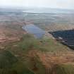
SC 1723674 |
RCAHMS Aerial Photography |
General oblique aerial view looking across the remains of the lead mines, engine house and the farmsteading towards Loch Finlaggan and the remains of the burial-ground, chapel, castle and island dwelling with Bowmore and Loch Indaal beyond, taken from the ENE. |
12/5/2005 |
Item Level |
|
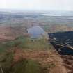 |
On-line Digital Images |
SC 1723675 |
RCAHMS Aerial Photography |
General oblique aerial view looking across the farmsteading towards Loch Finlaggan and the remains of the burial-ground, chapel, castle and island dwelling with Bowmore and Loch Indaal beyond, taken from the ENE. |
12/5/2005 |
Item Level |
|
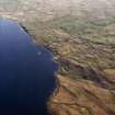 |
On-line Digital Images |
SC 1723679 |
RCAHMS Aerial Photography |
Oblique aerial view centred on the remains of the island dwelling, field-systems and rig, taken from the WSW. |
12/5/2005 |
Item Level |
|
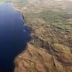 |
On-line Digital Images |
SC 1723680 |
RCAHMS Aerial Photography |
Oblique aerial view centred on the remains of the island dwelling, field-systems and rig, taken from the WSW. |
12/5/2005 |
Item Level |
|
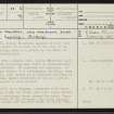 |
On-line Digital Images |
SC 2414258 |
Records of the Ordnance Survey, Southampton, Hampshire, England |
Islay, Loch Finlaggan, Eilean Mhuireill, NR36NE 23, Ordnance Survey index card, page number 1, Recto |
1958 |
Item Level |
|
 |
On-line Digital Images |
SC 2414259 |
Records of the Ordnance Survey, Southampton, Hampshire, England |
Islay, Loch Finlaggan, Eilean Mhuireill, NR36NE 23, Ordnance Survey index card, page number 2, Recto |
1958 |
Item Level |
|
 |
On-line Digital Images |
DP 410605 |
Records of the Royal Commission on the Ancient and Historical Monuments of Scotland (RCAHMS), Edinbu |
Eilean Mhuireill, Loch Finlaggan, Islay.
Survey plan of island dwelling.
Titled: 'Island dwelling, Eilean Muhuireill, Loch Finlaggan, Islay'. |
1976 |
Item Level |
|


