|
Prints and Drawings |
DC 44 |
Records of the Royal Commission on the Ancient and Historical Monuments of Scotland (RCAHMS), Edinbu |
Distribution map of hut circles, field systems, settlement and burnt mounds.
Inv p.12 RCAHMS. Copy in library. |
1984 |
Item Level |
|
|
Photographs and Off-line Digital Images |
DC 327 P |
Records of the Royal Commission on the Ancient and Historical Monuments of Scotland (RCAHMS), Edinbu |
Comparative plan of hut circles ink 1:400 RCAHMS Inv no. 252 (Print filed NR44NW 8) |
|
Item Level |
|
|
Prints and Drawings |
DC 366 |
Records of the Royal Commission on the Ancient and Historical Monuments of Scotland (RCAHMS), Edinbu |
PTS pencil 1:200 RCAHMS Dc40/p Topographical map of islands Jura, Islay, Colonsay, Oronsay. Inv p.1. RCAHMS |
1980 |
Item Level |
|
 |
On-line Digital Images |
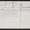
SC 2414210 |
Records of the Ordnance Survey, Southampton, Hampshire, England |
Islay, Duich, NR35SW 8, Ordnance Survey index card, page number 1, Recto |
1958 |
Item Level |
|
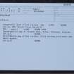 |
On-line Digital Images |
SC 2414211 |
Records of the Ordnance Survey, Southampton, Hampshire, England |
Islay, Duich, NR35SW 8, Ordnance Survey index card, Recto |
1958 |
Item Level |
|
|
All Other |
551 166/1/1 |
Records of the Ordnance Survey, Southampton, Hampshire, England |
Archaeological site card index ('495' cards) |
1947 |
Sub-Group Level |
|


