
Fair Isle, Kirki Geo


Cemetery (Medieval) - (Post Medieval), Chapel (Medieval)(Possible), Settlement (Period Unassigned)
Site Name Fair Isle, Kirki Geo
Classification Cemetery (Medieval) - (Post Medieval), Chapel (Medieval)(Possible), Settlement (Period Unassigned)
Alternative Name(s) South Harbour; Melville House; Fair Isle Kirkyard
Canmore ID 3756
Site Number HZ26NW 1
NGR HZ 20091 69918
Datum OSGB36 - NGR
Permalink http://canmore.org.uk/site/3756


- Council Shetland Islands
- Parish Dunrossness
- Former Region Shetland Islands Area
- Former District Shetland
- Former County Shetland
HZ26NW 1 2007 6990.
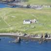
(Area: HZ 201 699) A small place of worship seems to have existed on Fair Isle from early times; its dedication is not known, but it produced a small revenue known as 'St. Peter's Stouk'. The name Kirki Geo borne by an adjoining creek, suggests that this chapel may have stood within a small burying ground, opposite the Post Office at the south end of the island, but no remains of anything of the kind are visible today. Several broken urns are said to have been unearthed within the burying ground.
RCAHMS 1946, visited 1930.
Local enquiries tend to confirm the RCAHMS suggestion that the chapel may have stood within the burial ground at HU 2009 6991. No further information.
Visited by OS (WDJ) 2 June 1968.
Cemy [NAT]
OS 1:10,000 map, 1973.
Possible chapel or monastic site located to W and SW of cemetery. Identified by a curving bank identified for c.40m with maximum height of c.0.3m and width c.1.5m. Bank appears to enclose a number of cell-like features (see J R Hunter 1984) although some of these may represent modern disturbance. Landscape features also reflected in fluxgate gradiometer survey (J R Hunter 1984).
Current cemetery located on site of earlier church and general area appears to be of traditional ecclesiastical antiquity.
J R Hunter 1984.
In 1983, a 7m long section, orientated NE-SW, parallel to and 2m from the cliff edge, was excavated by the Central Excavation Unit as part of an SDD-funded project examining five Iron Age sites in Shetland threatened by coastal erosion. Three phases were identified. Pottery sherds and bone were recovered. A single radiocarbon date from was obtained from Phase 2, demonstrating occupation in the seventh or eighth centuries AD. The excavation was supervised by John Barber.
S Carter, R McCullagh and A MacSween 1995.
Field Visit (18 August 1930)
Chapel, near Kirki-Geo. A small place of worship seems to have existed on the island from early times; its dedication is not known, but it produced a small revenue known as ‘St. Peter's Stouk’ (1). The name Kirki Geo, borne by an adjoining creek, suggests that this chapel may have stood within the small burying-ground, opposite the post office, at the S. end of the island, but no remains of anything of the kind are visible to-day. Several broken urns are said to have been unearthed within the burying-ground.
(1) Mill's Diary, p. lxxiii.
RCAHMS 1946, visited 18 August 1930
Field Visit (2 June 1968)
Local enquiries tend to confirm the RCAHMS suggestion that the chapel may have stood within the burial ground at HU 2009 6991. No further information.
Visited by OS (WDJ) 2 June 1968.
Excavation (1983)
In 1983, a 7m long section, orientated NE-SW, parallel to and 2m from the cliff edge, was excavated by the Central Excavation Unit as part of an SDD-funded project examining five Iron Age sites in Shetland threatened by coastal erosion. Three phases were identified. Pottery sherds and bone were recovered. A single radiocarbon date from was obtained from Phase 2, demonstrating occupation in the seventh or eighth centuries AD. The excavation was supervised by John Barber.
S Carter, R McCullagh and A MacSween 1995.
Field Visit (1984)
Possible chapel or monastic site located to W and SW of cemetery. Identified by a curving bank identified for c.40m with maximum height of c.0.3m and width c.1.5m. Bank appears to enclose a number of cell-like features (see J R Hunter 1984) although some of these may represent modern disturbance. Landscape features also reflected in fluxgate gradiometer survey (J R Hunter 1984).
Current cemetery located on site of earlier church and general area appears to be of traditional ecclesiastical antiquity.
J R Hunter 1984.
Magnetometry (1984)
Landscape features also reflected in fluxgate gradiometer survey (J R Hunter 1984).
J R Hunter 1984.

