
Islay, Ardnave Loch


Causeway (Period Unknown), Crannog (Period Unknown)(Possible)
Site Name Islay, Ardnave Loch
Classification Causeway (Period Unknown), Crannog (Period Unknown)(Possible)
Canmore ID 37483
Site Number NR27SE 18
NGR NR 28308 72637
Datum OSGB36 - NGR
Permalink http://canmore.org.uk/site/37483


- Council Argyll And Bute
- Parish Kilchoman
- Former Region Strathclyde
- Former District Argyll And Bute
- Former County Argyll
Field Visit (April 1977)
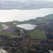
NR 283 726. In shallow water in the SW portion of Ardnave Loch, about 7m from the shore, there is an unnamed island, roughly circular in shape, which appears to be linked to the land by a causeway. On the date of visit the island measured about 36m in diameter, and its summit stood about 2m above water-level. As it is now almost wholly grass-covered, it is difficult to determine whether the island is entirely or only partially artificial in origin.
In the centre there are traces of at least five small slab-built structures resembling cists, which measure, on average, about 0.6m by 0.5m and 0.5m in depth. Three appear to be covered by 'capstones', and a fourth stone slab which may have served a similar purpose can be seen lying on the surface nearby. A short distance to the w there is a pronounced depression about 3m across, and the area immediately surrounding the structures seems to have been lightly quarried. Although the date and the purpose of the slab-built features are unknown, it is unlikely that they are the remains of a prehistoric burial-site.
Visited April 1977
RCAHMS 1984
Field Visit (10 June 1978)
At NR 2831 7262, on the SW side of Ardnave Loch, is a crannog, surviving as a completely turf covered flat topped mound of stones on a peninsula, some 0.5m to 1.0m. The crannog is 30.0m in diameter and about 1.0m high, the "depression about 10 1/2ft across" noted by Celoria (1959) is probably an animal burial pit. The course of the causeway is presumably obscured by the present broad, turf covered isthmus, but apart from a few scattered stones exposed where the soil is eroded, there is little visible remains.
In the centre of the crannog a mound has been erected, measuring 10.0m in diameter and 0.7m high. Its summit is disturbed revealing 5 cist-like structures of apparently no great age.
Surveyed at 1:10 000.
Visited by OS (N K B) 10 June 1978.
Desk Based Assessment (17 May 1978)
NR27SE 18 2831 7263.
NR 283 727. At the SW corner of Ardnave Loch is a circular 'island' 100ft in diameter joined to the shore by a short earthen causeway in which are embedded several rounded stones and a line of stepping stones. A group of at least 7 cist-like structures were exposed by removal of the turf. (Davies 1959) Each structure seemed to consist of two or three upright slabs at right angles to each other and there were several 'capstones'. The size of each 'cist' was about 2ft by 1ft 8ins by 1ft 9ins, although precise depth could not be ascertained because of the turf. About 27ft from the 'cists' towards the causeway end of the island, there was a depression about 10 1/2ft across, surrounded by stones. There may be slabs in the centre of the depression (Celoria 1959).
R E M Davies 1959; F Celoria 1959.
Crannog.
Information from RCAHMS.
Information from OS (ES) 17 May 1978.
Field Visit (1996)
NR 2831 7263 Located 12m from the SW edge of Ardnave Loch and accessed by an earthen causeway, 6.5m in width, which was just above water level at the time of survey. It was not possible to determine whether the causeway was a natural feature but probing revealed that it was not composed of stone. The artificial island is an oval grass-covered mound which measures 44m N-S by 50m E-W at its base, with the long axis running perpendicular to the near shore. The sides of the mound slope up gently at a 6? angle from the loch bed, and the submerged portions of the site are covered with a spread of small fist-sized stones. The summit of the mound is crowned with a circular platform, 15.5m in diameter, which stood 2m above the water level at the time of survey. The centre of the upper platform is occupied by the remains of five slab-built, cist-like structures which were heavily overgrown with turf. The capstones previously noted by the RCAHMS were not present.
Sponsors: Edinburgh University Archaeology Department, Holley & Associates.
M W Holley 1996

