|
Prints and Drawings |
DC 40 |
Records of the Royal Commission on the Ancient and Historical Monuments of Scotland (RCAHMS), Edinbu |
Topographical map of islands Jura, Islay, Colonsay, Oronsay.
Inv.p.1. RCAHMS Copy in library.
(Currently missing - 31/5/96) |
|
Item Level |
|
|
Prints and Drawings |
DC 44 |
Records of the Royal Commission on the Ancient and Historical Monuments of Scotland (RCAHMS), Edinbu |
Distribution map of hut circles, field systems, settlement and burnt mounds.
Inv p.12 RCAHMS. Copy in library. |
1984 |
Item Level |
|
|
Photographs and Off-line Digital Images |
A 4215 PO |
General Collection |
C.B. Burgess |
1976 |
Item Level |
|
|
Photographs and Off-line Digital Images |
A 4216 PO |
General Collection |
C.B. Burgess |
1976 |
Item Level |
|
|
Photographs and Off-line Digital Images |
A 4217 PO |
General Collection |
C.B. Burgess |
1976 |
Item Level |
|
|
Photographs and Off-line Digital Images |
A 4218 PO |
General Collection |
C.B. Burgess |
1976 |
Item Level |
|
|
Photographs and Off-line Digital Images |
A 4219 PO |
General Collection |
C.B. Burgess |
1976 |
Item Level |
|
|
Photographs and Off-line Digital Images |
DC 331 P |
Records of the Royal Commission on the Ancient and Historical Monuments of Scotland (RCAHMS), Edinbu |
Location map of monuments at Ardnave ink 1:10,000 RCAHMS Inv no. 241 and 242 |
1980 |
Item Level |
|
|
Photographs and Off-line Digital Images |
DC 332 P |
Records of the Royal Commission on the Ancient and Historical Monuments of Scotland (RCAHMS), Edinbu |
Excavation plan ink 1:50 RCAHMS |
1978 |
Item Level |
|
|
Prints and Drawings |
DC 333 |
Records of the Royal Commission on the Ancient and Historical Monuments of Scotland (RCAHMS), Edinbu |
Excavation plan pencil 1:50 RCAHMS |
1978 |
Item Level |
|
|
Prints and Drawings |
DC 334 |
Records of the Royal Commission on the Ancient and Historical Monuments of Scotland (RCAHMS), Edinbu |
Excavation plan dyeline 1:20 RCAHMS |
1978 |
Item Level |
|
|
Manuscripts |
MS 5037 |
|
Summary report on the excavation of a Hut-circle and enclosure at Ardnave, Islay. Including correspondence and comments. |
1977 |
Item Level |
|
|
Photographs and Off-line Digital Images |
H 99238 CS |
Papers of Dr J N Graham Ritchie, and Dr Anna Ritchie, archaeologists, Edinburgh, Scotland |
Hut circle excavated in the Ardnave sand dunes in 1976, Islay. |
1976 |
Item Level |
|
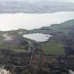 |
On-line Digital Images |
SC 1683205 |
RCAHMS Aerial Photography |
General oblique aerial view centred on the farmhouse, farmsteading and crannog with lazy beds adjacent, taken from the NW. |
12/5/2005 |
Item Level |
|
 |
On-line Digital Images |
SC 2413842 |
Records of the Ordnance Survey, Southampton, Hampshire, England |
Islay, Ardnave, NR27SE 15, Ordnance Survey index card, page number 1, Recto |
1958 |
Item Level |
|
 |
On-line Digital Images |
SC 2413843 |
Records of the Ordnance Survey, Southampton, Hampshire, England |
Islay, Ardnave, NR27SE 15, Ordnance Survey index card, Recto |
1958 |
Item Level |
|
|
Manuscripts |
MS 5036/3/5 |
Historic Scotland Archive Project |
Excavation Archive; Find and sample record cards. |
1976 |
Batch Level |
|
|
Manuscripts |
MS 5036/4/1 |
Historic Scotland Archive Project |
Post-excavation Archive; Project notebooks with annotated drawings and photographs. |
1991 |
Batch Level |
|
|
Photographs and Off-line Digital Images |
BP 130/7/2 |
Historic Scotland Archive Project |
Excavation photographs: Area N Ardnave hut excavation. |
1976 |
Batch Level |
|
|
Photographs and Off-line Digital Images |
BP 130/7/4 |
Historic Scotland Archive Project |
Excavation photographs: Box J2 souterrain section; working shots; stone setting J111; cobbling G132a in Box G2; pit in G2; Area N Ardnave hut; detail of souterrain walling in J2; Box G2 W baulk section; Box K3 stone with carved hole in situ. |
1976 |
Batch Level |
|
|
Photographs and Off-line Digital Images |
BP 130/7/7 |
Historic Scotland Archive Project |
Excavation photographs: Box J2; stones J110; J108; general view of stone features; clearing stones J106 and J108; cobbled area U102 in Box U1; Area N Ardnave hut; stone with carved hole from Box J2. |
1976 |
Batch Level |
|
|
Photographs and Off-line Digital Images |
BP 130/7/9 |
Historic Scotland Archive Project |
Excavation photographs: general shots of Ardnave shore and Ardnave hut excavations. |
1976 |
Batch Level |
|
|
Photographs and Off-line Digital Images |
BP 130/7/11 |
Historic Scotland Archive Project |
Excavation photographs: Area N Ardnave hut and features post-excavation. |
1976 |
Batch Level |
|
|
Prints and Drawings |
BD 118/6/7 |
Historic Scotland Archive Project |
Excavation drawings: location plan of Ardnave excavations; position of stones to bunker area; section through dunes; plans of house features, section through hearth and W section of sondage. |
1976 |
Batch Level |
|


