|
Prints and Drawings |
DC 40 |
Records of the Royal Commission on the Ancient and Historical Monuments of Scotland (RCAHMS), Edinbu |
Topographical map of islands Jura, Islay, Colonsay, Oronsay.
Inv.p.1. RCAHMS Copy in library.
(Currently missing - 31/5/96) |
|
Item Level |
|
|
Photographs and Off-line Digital Images |
DC 45 P |
Records of the Royal Commission on the Ancient and Historical Monuments of Scotland (RCAHMS), Edinbu |
Distribution map of forts, broch, duns. Inv. p.21. RCAHMS |
1984 |
Item Level |
|
|
Photographs and Off-line Digital Images |
AG 10792 |
Records of the Royal Commission on the Ancient and Historical Monuments of Scotland (RCAHMS), Edinbu |
RCAHMS |
1979 |
Item Level |
|
|
Photographs and Off-line Digital Images |
AG 10793 |
Records of the Royal Commission on the Ancient and Historical Monuments of Scotland (RCAHMS), Edinbu |
RCAHMS |
1979 |
Item Level |
|
|
Photographs and Off-line Digital Images |
DC 126 P |
Records of the Royal Commission on the Ancient and Historical Monuments of Scotland (RCAHMS), Edinbu |
Plan ink 1:400 RCAHMS Inv. no. 138 |
1981 |
Item Level |
|
|
Prints and Drawings |
DC 127 |
Records of the Royal Commission on the Ancient and Historical Monuments of Scotland (RCAHMS), Edinbu |
PTS pencil 1:400 RCAHMS |
1981 |
Item Level |
|
|
Photographs and Off-line Digital Images |
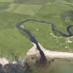
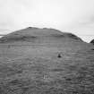
E 62781 CN |
RCAHMS Aerial Photography |
Oblique aerial view centred on the remains of the fort, taken from the N. |
12/5/2005 |
Item Level |
|
|
Photographs and Off-line Digital Images |
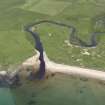
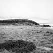
E 62783 CN |
RCAHMS Aerial Photography |
Oblique aerial view centred on the remains of the fort, taken from the SW. |
12/5/2005 |
Item Level |
|
 |
On-line Digital Images |
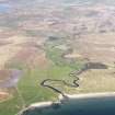
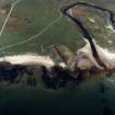
DP 112371 |
RCAHMS Aerial Photography Digital |
General oblique aerial view of Cnoc Ebric, Islay, looking up the River Laggan, taken from the SW. |
3/5/2011 |
Item Level |
|
 |
On-line Digital Images |
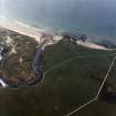
DP 142943 |
RCAHMS Aerial Photography Digital |
Oblique aerial view of Laggan Bay, River Laggan and Cnoc Ebric, looking NE. |
11/7/2012 |
Item Level |
|
 |
On-line Digital Images |
DP 142944 |
RCAHMS Aerial Photography Digital |
Oblique aerial view of Laggan Bay, River Laggan and Cnoc Ebric, looking NE. |
11/7/2012 |
Item Level |
|
 |
On-line Digital Images |
SC 1723725 |
RCAHMS Aerial Photography |
Oblique aerial view centred on the remains of the fort, taken from the N. |
12/5/2005 |
Item Level |
|
 |
On-line Digital Images |
SC 1723726 |
RCAHMS Aerial Photography |
Oblique aerial view centred on the remains of the fort, taken from the SW. |
12/5/2005 |
Item Level |
|
 |
On-line Digital Images |
SC 2254361 |
Records of the Royal Commission on the Ancient and Historical Monuments of Scotland (RCAHMS), Edinbu |
RCAHMS |
1979 |
Item Level |
|
 |
On-line Digital Images |
SC 2254362 |
Records of the Royal Commission on the Ancient and Historical Monuments of Scotland (RCAHMS), Edinbu |
RCAHMS |
1979 |
Item Level |
|
 |
On-line Digital Images |
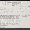
SC 2413436 |
Records of the Ordnance Survey, Southampton, Hampshire, England |
Islay, Cnoc Eabriic, NR25NE 7, Ordnance Survey index card, page number 1, Recto |
1958 |
Item Level |
|
 |
On-line Digital Images |
SC 2413437 |
Records of the Ordnance Survey, Southampton, Hampshire, England |
Islay, Cnoc Eabriic, NR25NE 7, Ordnance Survey index card, Recto |
1958 |
Item Level |
|
|
Prints and Drawings |
DC 45 |
Records of the Royal Commission on the Ancient and Historical Monuments of Scotland (RCAHMS), Edinbu |
Distribution map of forts, broch, duns. Inv. p.21. RCAHMS |
1984 |
Item Level |
|
|
All Other |
551 166/1/1 |
Records of the Ordnance Survey, Southampton, Hampshire, England |
Archaeological site card index ('495' cards) |
1947 |
Sub-Group Level |
|


