
Islay, Lossit


Dun (Later Prehistoric), Promontory Fort (Later Prehistoric)(Possible)
Site Name Islay, Lossit
Classification Dun (Later Prehistoric), Promontory Fort (Later Prehistoric)(Possible)
Canmore ID 37242
Site Number NR15NE 2
NGR NR 17249 56296
Datum OSGB36 - NGR
Permalink http://canmore.org.uk/site/37242


- Council Argyll And Bute
- Parish Kilchoman
- Former Region Strathclyde
- Former District Argyll And Bute
- Former County Argyll
NR15NE 2 1724 5628
(NR 1724 5628) A dun (RCAHMS) lying on a narrow ridge and measuring 20ft to 25ft within a wall 8ft to 11ft thick with a 5ft wide entrance in the E. The W wall footings are adapted to outcrop and stand some 6ft to 7ft higher than the wall remains on the E. Considerable tumble points to walls of some height. Several short stretches of walling block gullies in the cliff-face...On a slightly lower level to the S and a few feet from the above is an independently walled, and perhaps independent dun, trapezoidal in outline and 37ft E-W by 18ft to 29ft N-S over 7ft wide walls.
F Newall 1964
The remains of a coastal dun and annexe in a strong defensive position on a narrow rocky point. Only a few covered basal stones survive of the dun which appears to have been circular and 12.0m in overall diameter with walling 2.5m thick. Its position and the direction of tumble does suggest the wall was built over stepped rock on the seaward side.
The lower level annexe covers a slightly dished and featureless area generally as described, with only the N wall, 12.0m long and 1.3m high, intact. A 2.0m break at the W end of this wall indicates an entrance approach, the steep rocky ground below being crudely stepped and revetted with packed stone. No entrance to the dun was discernable.
As stated, the sheer gulleys around the dun all appear to have been stone blocked.
Surveyed at 1:10 000.
Visited by OS (JRL) 21 May 1978
Field Visit (July 1975)
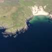
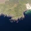
NR 172 562. This dun and its outwork occupy the W end of a rocky ridge running parallel to the seashore on the N side of Lossit Bay, about 1.2km W of Lossit farmhouse. It may be approached from the N with relative ease over grassy rock-studded slopes 13m high, but elsewhere the sides of the ridge are much more broken and, in places, precipitously steep, especially to the W of the dun, where the summit rises to a height of 32m above the level of the shore.
The dun measures 8m in diameter within a single stone wall, probably between 2.7m and 3.5m thick. Although many stones of the outer face and a few of the inner are still in position, the present state of the wall suggests that it may have suffered large-scale bodily collapse or even deliberate demolition, for scattered over the landward flank of the ridge and choking the gullies that face the sea, there is a considerable weight of tumbled core material. A possible explanation for this may be offered by the presence of two transverse spines of rock, which project through the foundations of the wall on the sw and continue some way into the interior. It is conceivable that such irregular ground would have made it difficult to provide a suitable base for the dun wall, and the structure, if carried to an extreme height, might have become dangerously unstable. Occupation of the site could thus have continued only if at least the upper portion of the wall had been dismantled, as in fact occurred at the broch of Dun Mor, Vaul, Tiree. (RCAHMS 1980). It is also noteworthy that the rock spines, by encroaching on the interior, might have appreciably diminished the habitable space within the dun. The entrance is situated on the NE, its position being indicated by a gap in the wall debris about 1.5m wide.
Further protection was provided by an outer wall, drawn along the crest on the N side of the ridge and returning along the W side of a narrow transverse gully about 16m to the E of the dun. The wall is now reduced to a band of stony debris, 2m in greatest thickness, in which several stretches and isolated stones of the outer face survive in position; it serves not only to protect the dun on its weaker side but also to enclose a lower shelf of habitable ground on the E. Most of the shelf is now occupied by the remains of an enclosure of no great age. The outwork is best preserved at the entrance, situated to the NE of the dun, where a portion of the w passage-wall survives to a height of 0.8m in four courses.
RCAHMS 1984 (visited July 1975).
Measured Survey (1975)
RCAHMS surveyed the dun at Lossit in 1975 at 1:400 using plane-table and self-reducing alidade. The plan was redrawn in ink and published at the reduced scale of 1:1000 (RCAHMS 1984, fig. 118B).
Note (23 September 2014 - 23 May 2016)
What may be a small promontory work is situated on a the W coast of the Rhins of Islay on the N side of the mouth of Lossit Bay. Previously regarded as an outwork to the stone-walled dun 8m in internal diameter on its summit, the defences comprise a wall about 2m in thickness, which extends along the precipitous lip of the promontory on the E and N, cutting off access from the landward side. Two stretches of the outer face are visible, and four courses of the facing on the W side of the entrance-passage, which lies midway along the wall on the N. The dun occupies the centre of the interior, which measures a maximum of 55m from E to W by 18m transversely (0.08ha), while a later agricultural enclosure occupies the E end, and the W end is bare rock.
Information from An Atlas of Hillforts of Great Britain and Ireland – 23 May 2016. Atlas of Hillforts SC2061

