
Cowie, St Mary's Church


Burial Ground (Period Unassigned), Church (Period Unassigned), Churchyard (Period Unassigned)
Site Name Cowie, St Mary's Church
Classification Burial Ground (Period Unassigned), Church (Period Unassigned), Churchyard (Period Unassigned)
Alternative Name(s) Cowie Chapel Of St Mary And St Nathalan; St Mary's Chapel
Canmore ID 36901
Site Number NO88NE 22
NGR NO 88417 87312
Datum OSGB36 - NGR
Permalink http://canmore.org.uk/site/36901


- Council Aberdeenshire
- Parish Fetteresso
- Former Region Grampian
- Former District Kincardine And Deeside
- Former County Kincardineshire
NO88NE 22.00 88417 87312
(NO 8842 8731) St Mary's Chapel (NR) (In Ruins)
OS 6" map, (1928).
NO88NE 22.01 NO 88414 87314 Dead House
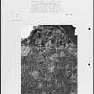
Cowie church was originally dedicated to St Nechtan or Nathalan (d. 679) but re-dedicated to the Virgin Mary on 22nd May, 1276. It was never a parish church, and was suppressed in the early 1560's.
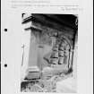
The internal measurements are 67ft 4ins by 18ft 10ins. It seems to have been lengthened at the west end during renovations in the 15th century, but the remainder appears to be 13th century. The north wall has been almost demolished, and the south wall was partially rebuilt about 1870. At the west end is an arched vault built in 1842.
The churchyard is still used for burials.
Watson (1926), basing his theory on an old rhyme, suggests that St Nechtan's tomb may lie between the church and the churchyard, although the Aberdeen Breviary states that he was buried at Tullich.
New Statistical Account (NSA) 1845; W J Watson 1926; J B Burnett 1927.
The church is as described above, except that it measures 20.6m by 6.3m externally, with walls 0.9m thick. It is known locally as St Mary's Church.
Visited by OS (R D) 23 July 1965.
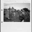
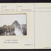
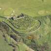
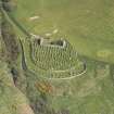
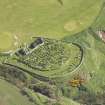
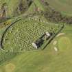
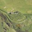
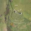
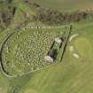
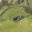
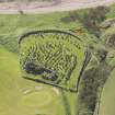
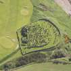
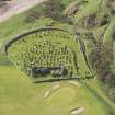
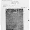
The roofless ruin of this chapel stands within a curvilinear, walled burial-ground at the head of the cliffs 100m SSE of Cowie golf course clubhouse and 180m NNE of Cowie Castle (NO88NE 21). Rectangular on plan, it measures 20.45m by 5.45m within wall 0.9m in thickness; there are three lancets in the E gable and an aumbry in the N wall. The eastern portion of the chapel appears to be of 13th-century date. The building was originally 13.75m long but during the 16th century it was renovated and enlarged; in the 19th century a barrel-vaulted chamber was added to the W gable. The chapel comes on record in 1276.
A P Forbes 1872; W Kelly 1889; D MacGibbon and T Ross 1896-7; J B Burnett 1927; RCAHMS 1984, visited October 1983.
(Name cited as NO88NE 20). Air photograph: AAS/94/05/G13/9.
NMRS, MS/712/21.
NO88NE 22.00 88417 87312
EXTERNAL REFERENCE:
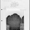
Cowie Church (St. Mary's) - ruins.
Plans:
1/4" scale complete. Measured and drawn by P.H. Douglas. Measured with Ian McLaren.
Drawings stored at 40 Eastbury Road, Watford. 1927-1928.
(Students of the Aberdeen School of Architecture).
Measured only, no drawings prepared. Measured by Dorothy P. Soper. 1924-1926.
(Student of the Aberdeen School of Architecture)
Surveys stored at Malcolm's Mount, Stonehaven.
National Library of Scotland.
Transactions of the Aberdeen Ecclesiastical Society, 1886.
Aberdeen Public Library, Reference Dept.
PLANS: W. Kelly 'Some Ancient Churches near Aberdeen.' 1886

