|
Photographs and Off-line Digital Images |
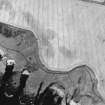
E 11870 |
RCAHMS Aerial Photography |
Oblique aerial view of Kinghornie chapel site centred on at least one linear cropmark with possible associated pits, taken from the ESE. |
17/8/2001 |
Item Level |
|
|
Photographs and Off-line Digital Images |
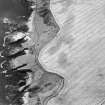
E 11871 |
RCAHMS Aerial Photography |
Oblique aerial view of Kinghornie chapel site centred on at least one linear cropmark with possible associated pits, taken from the ENE. |
17/8/2001 |
Item Level |
|
 |
On-line Digital Images |
SC 1723047 |
RCAHMS Aerial Photography |
Oblique aerial view of Kinghornie chapel site centred on at least one linear cropmark with possible associated pits, taken from the ESE. |
17/8/2001 |
Item Level |
|
 |
On-line Digital Images |
SC 1723048 |
RCAHMS Aerial Photography |
Oblique aerial view of Kinghornie chapel site centred on at least one linear cropmark with possible associated pits, taken from the ENE. |
17/8/2001 |
Item Level |
|
 |
On-line Digital Images |
SC 2412564 |
Records of the Ordnance Survey, Southampton, Hampshire, England |
Kinghornie, NO87SW 9, Ordnance Survey index card, Recto |
1958 |
Item Level |
|
 |
On-line Digital Images |
SC 2695236 |
Records of the Ordnance Survey, Southampton, Hampshire, England |
Kinghornie, NO87SW 9, Ordnance Survey index card, page number 1, Recto |
1958 |
Item Level |
|
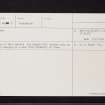 |
On-line Digital Images |
SC 2695237 |
Records of the Ordnance Survey, Southampton, Hampshire, England |
Kinghornie, NO87SW 9, Ordnance Survey index card, page number 2, Verso |
1958 |
Item Level |
|
|
All Other |
551 166/1/1 |
Records of the Ordnance Survey, Southampton, Hampshire, England |
Archaeological site card index ('495' cards) |
1947 |
Sub-Group Level |
|


