
Kinghornie


Chapel (14th Century)(Possible), Cropmark(S) (Medieval)(Possible), Spring (Medieval)(Possible)
Site Name Kinghornie
Classification Chapel (14th Century)(Possible), Cropmark(S) (Medieval)(Possible), Spring (Medieval)(Possible)
Alternative Name(s) Chapel Well
Canmore ID 36886
Site Number NO87SW 9
NGR NO 8391 7261
NGR Description NO 8391 7261 to NO 8390 7256
Datum OSGB36 - NGR
Permalink http://canmore.org.uk/site/36886


- Council Aberdeenshire
- Parish Bervie
- Former Region Grampian
- Former District Kincardine And Deeside
- Former County Kincardineshire
NO87SW 9 8391 7261 to 8390 7256.
(NO 8391 7261) Chapel (NR) (Site of)
(NO 8390 7256) Chapel Well (NR)
OS 6" map (1959)
The site of a chapel said to have been founded by David II in 1341. No remains exist but the site is well-known and the ruins still stood at the end of the 18th century. The Chapel Well is a spring.
Name Book 1864
The chapel does not appear in the Register of Ministers for 1567.
A Jervise 1882
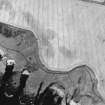
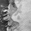
Enclosure visible on AP's (OS 67/287/028-9, flown 1967).
(Undated) information in NMRS.
No trace of this chapel: the Chapel Well remains only as a slight seepage in a bank with virtually no flow.
Visited by OS (NKB) 21 December 1967
Oblique aerial photography (RCAHMSAP 2001) has recorded the cropmarks of an L-shaped ditch on a promontory on which there is recorded a chapel site. The feature is also recorded on vertical aerial photographs (OS 67/287/028-9, flown 1967), and may be associated with two pits inside, and perhaps further linear cropmarks immediately to the NW.
Information from RCAHMS (SMDG) 7 January 2003
Field Visit (March 1982)
Kinghornie, Chapel NO 839 726 NO87SW 9
Nothing remains of the medieval chapel that is said to have stood 310m E of Kinghornie farmhouse and to have been visible at the end of the 18th century.
RCAHMS 1982, visited March 1982
(Stat. Acct., vi, 1793, 208;NSA, xi, Kincardine, 311-12;Jervise 1885, ii, 159-60, Footnote)

