
Kinghornie


Grave(S) (Period Unassigned)(Possible)
Site Name Kinghornie
Classification Grave(S) (Period Unassigned)(Possible)
Canmore ID 36864
Site Number NO87SW 35
NGR NO 8360 7264
Datum OSGB36 - NGR
Permalink http://canmore.org.uk/site/36864


- Council Aberdeenshire
- Parish Kinneff
- Former Region Grampian
- Former District Kincardine And Deeside
- Former County Kincardineshire
NO87SW 35 8360 7264
See also NO87SW 64.
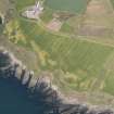
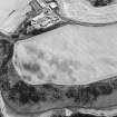
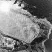
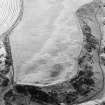
Oblique aerial photography (RCAHMSAP 2001) has recorded the cropmarks of possible graves adjacent to Kinghornie farmsteading (NO87SW 57), listed in the Scottish Castle Survey (Bogdan and Bryce 1991). The graves consist of about ten pits aligned from E to W and arranged in four rows across a gently sloping terrace about 75m to the N and NW of the coastline. About 25m to the E are the cropmarks of probable round-houses and other cropmarks (NO87SW 64).
Information from RCAHMS (SMDG) 17 December 2002

