
North Water Viaduct


Railway Viaduct (19th Century)
Site Name North Water Viaduct
Classification Railway Viaduct (19th Century)
Alternative Name(s) Scottish North Eastern, Montrose And Bervie Railway; Fisherhills; North Water Of Esk; Fisherhills; Esk Valley Viaduct
Canmore ID 36373
Site Number NO76SW 39
NGR NO 72513 62217
Datum OSGB36 - NGR
Permalink http://canmore.org.uk/site/36373


- Council Aberdeenshire
- Parish St Cyrus
- Former Region Grampian
- Former District Kincardine And Deeside
- Former County Kincardineshire
NO76SW 39 72513 62217
Viaduct [NAT]
OS 1:10,000 map, 1976.
Location formerly entered as NO 72503 62247.
For mill lead (NO 710 628), see NO76SW 49.
For (adjacent to W) Lower North Water (road) Bridge, see NO76SW 38.
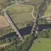
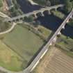
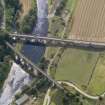
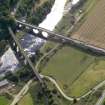
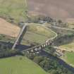
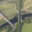
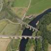
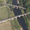
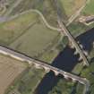
(Location cited as NO 724 622). North Water Viaduct, Fisherhills. Opened 1865 by the Montrose and Bervie Rly. An 11-span masonry viaduct with five slightly-skewed arches over the river and six smaller land arches; all are semicircular.
J R Hume 1977.
The (North British Rly.) branch from Montrose to Inverbervie was originally promoted as part of a coastal through route to Aberdeen and opened to passenger traffic on 1 November 1865. This was its major engineering work and carried the track over the North Water of Esk at a height of about 75 ft (22.9m).The line closed to traffic on 23 May 1966, but the viaduct remains standing. The river piers were repaired in 1992-3.
M Smith 1994.
This viaduct formerly carried the Bervie branch railway over the River North Esk, which here forms the boundary between the parishes of St Cyrus (Kincardineshire) and Montrose (Angus), to the N and S respectively.
Information from RCAHMS (RJCM), 18 June 1997.
This bridge carries the A92 public road over the River North Esk, which here forms the boundary between the parishes of Montrose (Angus and Tayside Region) and St Cyrus (Kincardineshire and Grampian Region), to the S and N respectively.
Information from RCAHMS (RJCM), 29 April 1998.
Opened in 1865 by the Montrose and Bervie Railway, this rubble-built viaduct comprises eleven semi-circular arches which carried the track over the River North Esk to the north of Montrose. The railway was closed in 1966, but at the time of survey in 2002, the viaduct had been refurbished and re-opened as a footpath.
Information from RCAHMS (MKO), 2002.
The location assigned to this record defines the apparent midpoint of the structure. The available map evidence indicates that it extends from NO c. 72491 62310 to NO c. 72527 62135.
Information from RCAHMS (RJCM), 20 April 2006.
Photographic Survey (4 February 1987)
Photographic Survey (26 February 2002)
Opened in 1865 by the Montrose and Bervie Railway, this rubble-built viaduct comprises eleven semi-circular arches which carried the track over the River North Esk to the north of Montrose. The railway was closed in 1966, but at the time of survey in 2002, the viaduct had been refurbished and re-opened as a footpath.
Publication Account (2007)
This large masonry viaduct was built to carry the Montrose and Bervie Railway, opened 1865, over the Upper North Water. It is partially curved on plan and has 12 spans, seven land arches and five larger skewed arches over the river. The latter are supported by heavier piers particularly those on the river banks. This section of the former railway from the viaduct to St Cyrus is intended to form part of the
National Cycle Netwo rk.
R Paxton and J Shipway 2007b
Reproduced from 'Civil Engineering heritage: Scotland - Highlands and Islands' with kind permission of Thomas Telford Publishers.
Publication Account (2013)
The two bridges are best viewed by taking the minor road to Warburton (‘Steptoes’) on the north side, as the bends on the A92 do not suit a stop. The former rail viaduct then permits a pedestrian route to the south end of the road bridge.
The A92 Lower North Water Bridge was built in 1770 - 1775 by Andrew Barrie using a design of John Smeaton and contract drafted by John Adam. All three are credited in Latin, beside the major landowner. 7 arches with cutwaters, the centre having 63’ span. Barrie was joint contractor with Andrew Brown.
Northwater Bridge Viaduct, a 12-arch railway viaduct, 5 of them skewed over the river, was built in1865 for the Montrose and Bervie Railway by Blyth and Blyth. The junction between the skewed river spans and the more conventional arches required an extra thick pier. It was repaired c2000 and passed to Sustrans as part of a long-distance cycle route.
M Watson, 2013

