
East Mathers, Limekilns


Enclosure (Period Unassigned), Lime Kiln(S) (Period Unassigned)
Site Name East Mathers, Limekilns
Classification Enclosure (Period Unassigned), Lime Kiln(S) (Period Unassigned)
Canmore ID 36318
Site Number NO76NE 22
NGR NO 7822 6628
NGR Description NO 7822 6628 and NO 7815 6621
Datum OSGB36 - NGR
Permalink http://canmore.org.uk/site/36318


- Council Aberdeenshire
- Parish St Cyrus
- Former Region Grampian
- Former District Kincardine And Deeside
- Former County Kincardineshire
NO76NE 22 7822 6628 and 7815 6621
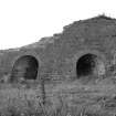
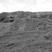
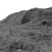
(Described with icehouse NO76NE 23). Limekilns, East Mathers, built c. 1750 and later. The much decayed remains of a single kiln and a pair of kilns, both stone-lined, and the more complete remains of a 3- or 4-drawkiln built of rubble with brick arch rings over the draw-holes.
J R Hume 1977
An enclosure with a lime kiln built into one corner is depicted on the 1st edition of the OS 6-inch map (Kincardineshire 1865-8, sheet xxvii) and on the current edition of the OS 1:10000 map (1974).
Information from RCAHMS (SAH) 17 June 1999

