|
Photographs and Off-line Digital Images |
E 99165 CS |
RCAHMS Aerial Photography |
Oblique aerial view centred on the remains of the fort, taken from the NNE. |
1/8/1998 |
Item Level |
|
|
Photographs and Off-line Digital Images |
E 99166 CS |
RCAHMS Aerial Photography |
Oblique aerial view centred on the remains of the fort, taken from the WSW. |
1/8/1998 |
Item Level |
|
|
Photographs and Off-line Digital Images |
E 99167 CS |
RCAHMS Aerial Photography |
Oblique aerial view centred on the remains of the fort, taken from the SW. |
1/8/1998 |
Item Level |
|
 |
On-line Digital Images |
SC 2411519 |
Records of the Ordnance Survey, Southampton, Hampshire, England |
Red Head, NO74NW 2, Ordnance Survey index card, Recto |
1958 |
Item Level |
|
 |
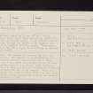
On-line Digital Images |
SC 2411520 |
Records of the Ordnance Survey, Southampton, Hampshire, England |
Red Head, NO74NW 2, Ordnance Survey index card, Recto |
1958 |
Item Level |
|
|
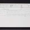
All Other |
551 166/1/1 |
Records of the Ordnance Survey, Southampton, Hampshire, England |
Archaeological site card index ('495' cards) |
1947 |
Sub-Group Level |
|


