
Green Castle


Earthwork (Medieval)
Site Name Green Castle
Classification Earthwork (Medieval)
Canmore ID 36089
Site Number NO67NE 4
NGR NO 66892 76499
Datum OSGB36 - NGR
Permalink http://canmore.org.uk/site/36089


- Council Aberdeenshire
- Parish Fettercairn
- Former Region Grampian
- Former District Kincardine And Deeside
- Former County Kincardineshire
NO67NE 4 6688 7648.
(NO 6688 7648) Green Castle (NR) Earthwork (NR)
OS 1:10,000 map, (1977)
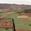
Green Castle, noted as a native fort by Crawford, occupies a strong position on a high point of land overlooking the Devilly Burn, 650m NW of Mill of Kincardine farmhouse.
It is defended by a single earthen rampart 8 or 9ft broad on the top, rising as much above the interior and falling steeply 20 to 30ft in perpendicular height upon a wide trench with a counterscarp 3 to 8ft high. The height of the rampart above the interior is a peculiar character and shows that it must have been defended from the broad top, probably from behind a palisade.
(Christison's [1900] section of this earthwork suggests that this may have been a motte, in which case it may be a fore-runner of Kincardine Castle (NO67NE 10) which Cruden says has a history going back to the 12th century although the present castle is 13th century. Watt calls it 'Caer-na-Mounth' or 'Fotherdun' and deduces that it was the seat of the early medieval Maermors of the Mearns.)
O G S Crawford 1949; D Christison 1900; S H Cruden 1960; J C Watt 1914.
Green Castle, a strong, well-preserved earthwork, comprises a scarped natural hillock, now wooded, with an earthen rampart around its summit, and a ditch with a denuded outer rampart around its base. The sides of the hillock have been steepened and the top levelled, the material going into the construction of the massive rampart around the rim, which varies between 14.0m in width and 2.5m in height in the NE, and about 6.5m in width and 1.0m in height in the SE. The entrance, in the NE, denoted by a break in the rampart 2.5m wide, is opposite a causeway, 3.5m wide, across the ditch. Another break, about 3.0m wide, in the SW, appears to be for drainage purposes and is probably of a later period. A hollow, shown on Christison's plan, in the S, has probably been caused by an uprooted tree. The ditch varies in width from about 11.0m in the N, at the easiest approach, where it is best preserved, to about 4.0m in the S where it is represented by a mere terrace. The outer rampart is ploughed out in the NE and is mutilated by trees and soil slip elsewhere. In the NW a capping of stones is due to a ruinous modern wall which has surmounted it.
Resurveyed at 1:2500.
Visited by OS (I S S) 12 August 1971.
This earthwork has no local parallel, but bears a strong similarity to a 13/14th century earthwork called 'The Mount' at Cheswick Green, Birmingham (Jones 1953), and resembles a class of 'motte' designated 'crater type' by Renn (1959). It looks more medieval in character than Iron Age, and would give a site for the forerunner of Kincardine Castle (Cruden 1960).
T L Jones 1953; D F Renn 1959.
From ground inspection, there is little doubt that this earthwork is medieval, probably an early 'crater type' motte as suggested above. Its situation and form of construction is also closely paralleled in a similarly-named 'Green Castle' at Wooler (NT 982 279), classified by King and Alcock (1969) as a 'ringwork'.
D J C King and L Alcock 1969; Visited by OS (ECW) 13 November 1972.
Listed.
Scottish Castle Survey 1988; N Bogdan and I B D Bryce 1991.
Field Visit (13 September 1956)
This site was included within the RCAHMS Marginal Land Survey (1950-1962), an unpublished rescue project. Site descriptions, organised by county, are available to view online - see the searchable PDF in 'Digital Items'. These vary from short notes, to lengthy and full descriptions. Contemporary plane-table surveys and inked drawings, where available, can be viewed online in most cases - see 'Digital Images'. The original typecripts, notebooks and drawings can also be viewed in the RCAHMS search room.
Information from RCAHMS (GFG) 19 July 2013.
Field Visit (March 1982)
Green Castle NO 668 765 NO67NE 4
The earthwork that encloses a knoll overlooking the E bank of the Devilly Burn, 650m NW of Mill of Kincardine farmhouse, is probably the remains of an early-medieval castle. It is trapezoidal and measures about 65m by a maximum of 35m internally; the massive earthen rampart is up to 14m thick, and stands to a height of 3.3m above the interior, and over 10m above the bottom of an external ditch up to 11m broad. On the NW and SE there is an outer rampart, and the entrance is on the NE.
RCAHMS 1982, visited March 1982
(Chalmers 1887-1902, i, 178, footnote; Christison 1900, 60-1)

