|
Photographs and Off-line Digital Images |
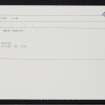
A 77369 |
Records of the Ordnance Survey, Southampton, Hampshire, England |
OS |
1970 |
Item Level |
|
|
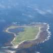
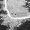
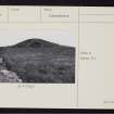
Photographs and Off-line Digital Images |
D 14709 |
RCAHMS Aerial Photography |
Oblique aerial view of Sanday, Start Point Lighthouse, lightkeeper's house and steading, taken from the E. Also visible is 'Mount Maesry' chambered cairn |
5/8/1997 |
Item Level |
|
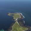 |
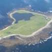
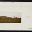
On-line Digital Images |
DP 068342 |
RCAHMS Aerial Photography Digital |
General oblique aerial view towards Start Point lighthouse, taken from the W. |
5/8/2009 |
Item Level |
|
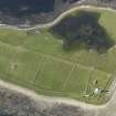 |
On-line Digital Images |
DP 068343 |
RCAHMS Aerial Photography Digital |
Oblique aerial view centred on Start Point lighthouse with Mount Maestry chambered cairn adjacent, taken from the SSE. |
5/8/2009 |
Item Level |
|
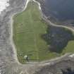 |
On-line Digital Images |
DP 068344 |
RCAHMS Aerial Photography Digital |
Oblique aerial view centred on Start Point lighthouse with Mount Maestry chambered cairn adjacent, taken from the E. |
5/8/2009 |
Item Level |
|
 |
On-line Digital Images |
DP 244291 |
Historic Environment Scotland |
Oblique aerial view. |
16/8/2016 |
Item Level |
|
 |
On-line Digital Images |
DP 244293 |
Historic Environment Scotland |
Oblique aerial view. |
16/8/2016 |
Item Level |
|
 |
On-line Digital Images |
SC 1691773 |
RCAHMS Aerial Photography |
Oblique aerial view of Sanday, Start Point Lighthouse, lightkeeper's house and steading, taken from the E. Also visible is 'Mount Maesry' chambered cairn |
5/8/1997 |
Item Level |
|
 |
On-line Digital Images |
SC 2243797 |
Records of the Ordnance Survey, Southampton, Hampshire, England |
OS |
1970 |
Item Level |
|
 |
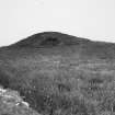
On-line Digital Images |
SC 2344329 |
Records of the Ordnance Survey, Southampton, Hampshire, England |
Sanday, Mount Maesry, HY74SE 4, Ordnance Survey index card, page number 1, Recto |
1958 |
Item Level |
|
 |
On-line Digital Images |
SC 2344330 |
Records of the Ordnance Survey, Southampton, Hampshire, England |
Sanday, Mount Maesry, HY74SE 4, Ordnance Survey index card, page number 2, Verso |
1958 |
Item Level |
|
 |
On-line Digital Images |
SC 2344331 |
Records of the Ordnance Survey, Southampton, Hampshire, England |
Sanday, Mount Maesry, HY74SE 4, Ordnance Survey index card, Recto |
1958 |
Item Level |
|
 |
On-line Digital Images |
SC 2344332 |
Records of the Ordnance Survey, Southampton, Hampshire, England |
Sanday, Mount Maesry, HY74SE 4, Ordnance Survey index card, page number 1, Recto |
1958 |
Item Level |
|
 |
On-line Digital Images |
SC 2344333 |
Records of the Ordnance Survey, Southampton, Hampshire, England |
Sanday, Mount Maesry, HY74SE 4, Ordnance Survey index card, page number 2, Verso |
1958 |
Item Level |
|
 |
On-line Digital Images |
SC 2344334 |
Records of the Ordnance Survey, Southampton, Hampshire, England |
Sanday, Mount Maesry, HY74SE 4, Ordnance Survey index card, Recto |
1958 |
Item Level |
|
|
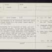
All Other |
551 166/1/1 |
Records of the Ordnance Survey, Southampton, Hampshire, England |
Archaeological site card index ('495' cards) |
1947 |
Sub-Group Level |
|


