
Inchbare


Pit Alignment (Prehistoric), Pit Enclosure (Prehistoric)
Site Name Inchbare
Classification Pit Alignment (Prehistoric), Pit Enclosure (Prehistoric)
Alternative Name(s) Inchbare South; Inchbare 1
Canmore ID 35980
Site Number NO66NW 49
NGR NO 60800 65464
Datum OSGB36 - NGR
Permalink http://canmore.org.uk/site/35980


- Council Angus
- Parish Stracathro
- Former Region Tayside
- Former District Angus
- Former County Angus
NO66NW 49 NO 60800 65464
A pit-defined cursus lies parallel to the pit-alignment. (see NO66NW41)
Note (1983)
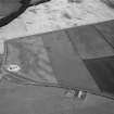
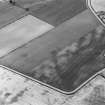
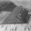
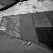
Inchbare 1 NO 607 654 to 610 656 NO66NW 49
Cropmarks reveal three parallel lines of pits running from WSW to ENE across the field to the SE of Inchbare. Two of the lines of pits, which extend for a distance of at least 300m, are set about 20m apart, and unite at the WSW end in a square terminal; the third line lies about 10m to the SSE. Immediately S of the WSW end there are traces of a rectangular pit-defined structure measuring about 20m by 9m internally.
RCAHMS 1983.
Aerial Photographic Transcription (1 June 1992 - 4 June 1992)
An aerial transcription was produced from oblique aerial photographs. Information from Historic Environment Scotland (BM) 31 March 2017.

