|
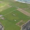
Photographs and Off-line Digital Images |
D 14717 |
RCAHMS Aerial Photography |
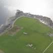
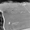
Oblique aerial view of Sanday, Whale Head (Lopness) Radar Station, taken from the SSE |
5/8/1997 |
Item Level |
|
|
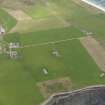
Photographs and Off-line Digital Images |
D 14720 |
RCAHMS Aerial Photography |
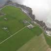
Oblique aerial view of Sanday, Whale Head (Lopness) Radar Station, taken from the E. |
5/8/1997 |
Item Level |
|
|
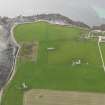
Photographs and Off-line Digital Images |
D 14791 |
RCAHMS Aerial Photography |
Oblique aerial view of Huntington centred on the cropmarks of a settlement and barrow, taken from the NW. |
8/8/1997 |
Item Level |
|
|
Photographs and Off-line Digital Images |
O 729 |
|
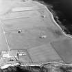
General view. |
9/1965 |
Item Level |
|
 |
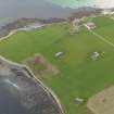
On-line Digital Images |
DP 055830 |
RCAHMS Aerial Photography Digital |
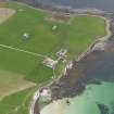
Oblique aerial view centred on the radar station with the farmstead adjacent, taken from the SW. |
24/9/2008 |
Item Level |
|
 |
On-line Digital Images |
DP 055831 |
RCAHMS Aerial Photography Digital |
Oblique aerial view centred on the radar station with the farmstead adjacent, taken from the SSW. |
24/9/2008 |
Item Level |
|
 |
On-line Digital Images |
DP 055832 |
RCAHMS Aerial Photography Digital |
Oblique aerial view centred on the radar station with the farmstead adjacent, taken from the SE. |
24/9/2008 |
Item Level |
|
 |
On-line Digital Images |
DP 055833 |
RCAHMS Aerial Photography Digital |
Oblique aerial view centred on the radar station with the farmstead adjacent, taken from the ENE. |
24/9/2008 |
Item Level |
|
 |
On-line Digital Images |
DP 055834 |
RCAHMS Aerial Photography Digital |
Oblique aerial view centred on the radar station with the farmstead adjacent, taken from the NE. |
24/9/2008 |
Item Level |
|
 |
On-line Digital Images |
DP 055835 |
RCAHMS Aerial Photography Digital |
Oblique aerial view centred on the radar station with the farmstead adjacent, taken from the NNE. |
24/9/2008 |
Item Level |
|
 |
On-line Digital Images |
DP 055836 |
RCAHMS Aerial Photography Digital |
Oblique aerial view centred on the radar station with the farmstead adjacent, taken from the NNW. |
24/9/2008 |
Item Level |
|
 |
On-line Digital Images |
SC 1691781 |
RCAHMS Aerial Photography |
Oblique aerial view of Sanday, Whale Head (Lopness) Radar Station, taken from the SSE |
5/8/1997 |
Item Level |
|
 |
On-line Digital Images |
SC 1691784 |
RCAHMS Aerial Photography |
Oblique aerial view of Sanday, Whale Head (Lopness) Radar Station, taken from the E. |
5/8/1997 |
Item Level |
|
 |
On-line Digital Images |
SC 1742424 |
RCAHMS Aerial Photography |
Oblique aerial view of Huntington centred on the cropmarks of a settlement and barrow, taken from the NW. |
8/8/1997 |
Item Level |
|
 |
On-line Digital Images |
SC 2344364 |
Records of the Ordnance Survey, Southampton, Hampshire, England |
Sanday, Lopness House, HY74SE 21, Ordnance Survey index card, Recto |
1958 |
Item Level |
|


