
Stracathro


Geological Feature(S) (Period Unassigned), Temporary Camp (Roman)
Site Name Stracathro
Classification Geological Feature(S) (Period Unassigned), Temporary Camp (Roman)
Alternative Name(s) Smiddyhill; Inchbare; West Water
Canmore ID 35940
Site Number NO66NW 13
NGR NO 61370 65610
NGR Description Centred NO 61370 65610
Datum OSGB36 - NGR
Permalink http://canmore.org.uk/site/35940


- Council Angus
- Parish Stracathro
- Former Region Tayside
- Former District Angus
- Former County Angus
NO66NW 13 centred NO 61370 65610
See also NO66NW 18.
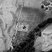
For circular enclosure at Smiddyhill (NO 6145 6586) within the scheduled area, see NO66NW 89.
No trace
Visited by OS 8 September 1971.
Scheduled with NO66NW 18 as Stracathro, Roman fort and camp.
Information from Historic Scotland, scheduling document dated 22 March 2002.
Note (1983)
Stracathro, Temporary Camp NO 613 656 NO66NW 13
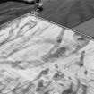
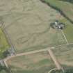
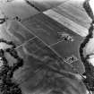
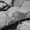
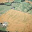
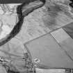
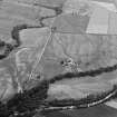
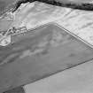
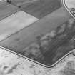
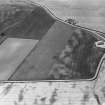
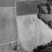
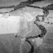
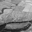
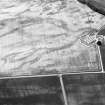
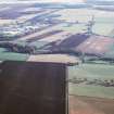
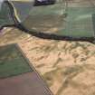
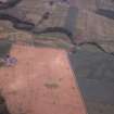
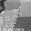
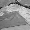
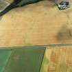
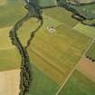
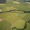
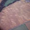
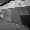
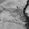
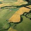
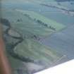
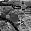
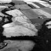
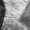
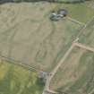
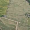
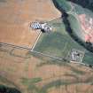
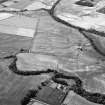
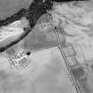
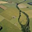
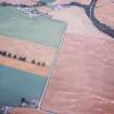
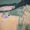
Situated immediately SW of the fort NO66NW 18, there is a temporary camp, a rectangular parallelogram on plan, measuring about 425m from NW to SE by 375m (c. 15.8ha). Its four clavicular gateways of distinctive 'Stracathro' type combine with its presumed relationship to the adjacent Flavian fort NO66NW 18 to suggest that it was constructed during the campaigns of Julius Agricola in AD 78-84.
RCAHMS 1983.
(St Joseph 1970, 171-5).
Watching Brief (19 February 2009 - 22 February 2009)
NO 6150 6569 A watching brief was maintained at two points within the area of Stracathro Roman temporary camp and fort on 19–22 February 2009. The laying of a c7m long low voltage underground electricity cable, c60m SW of Smiddy farmhouse, and the replacement of two electricity poles, c120m S of Stracathro church, were monitored. No archaeological features or finds were recorded.
Archive: Aberdeenshire SMR, Historic Scotland and RCAHMS
Funder: SSE Power Distribution
JC Murray – Murray Archaeological Services Ltd
Publication Account (17 December 2011)
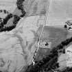
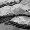
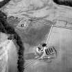
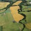
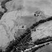
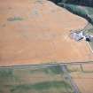
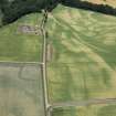
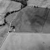
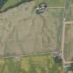
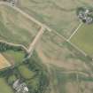
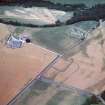
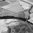
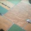
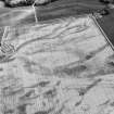
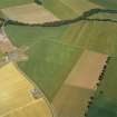
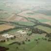
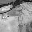
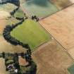
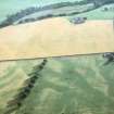
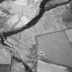
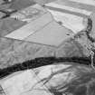
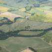
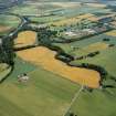
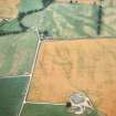
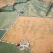
The camp at Stracathro was discovered from the air by St Joseph in 1955 (1955: 87), the neighbouring Roman fort being discovered two years later (St Joseph 1958: 91). It lies on level ground on a triangular spur between the West Water to the north and the Cruick Water to the east (both tributaries of the River North Esk). Stracathro Church lies immediately to the east, within the Roman fort, the annexe of which intersects the south part of the northeast side of the camp.
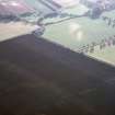
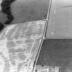
All four sides of the camp have been recorded through cropmarks, and it measures 442m from north-west to south-east by 370m transversely, enclosing 16.2ha (40 acres). All four gateways are recorded, in the centre of the north-west and south-east sides, and towards the south-east end of the other two sides. The entrances are protected by an external clavicula ditch and oblique traverse, giving rise to the expression ‘Stracathro-type’ for the particular gate arrangement (despite the fact that St Joseph noticed the similarity of the gates to the camp at Dalginross (1955: 87), recorded two centuries earlier by Roy; see above, section 7b).
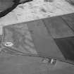
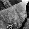
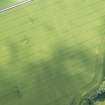
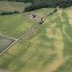
St Joseph excavated a series of trenches in 1967, recording that the ditch was up to 2.9m in width and up to 1.2m in depth (RCAHMS St Joseph Collection: Notebook 4). The clavicula on the north-west side was also sectioned, revealing a shallow V-shaped ditch, measuring about 2.4m in width and 1m in depth (St Joseph 1970a: 171–5). A number of pits are visible within the camp, but these are of limited regularity and their association with the camp is unknown.
R H Jones.
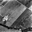
Geophysical Survey (2012)
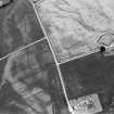
NO 6170 6575 and NO 61370 65610 Resistance and magnetic surveys were conducted, taking in the entire surviving area of the Roman fort (except for the modern parish churchyard), along with its annexe and part of the temporary camp to the W. The defences showed clearly over most of their course, with the 'parrot beak' style gates, but the impression of a triple ditch, gained in the past from the air, seems to have been caused by the rampart showing as a third linear cropmark in aerial views. The magnetic survey showed what are probably lines of pits in the interior, which may represent the postholes of barrack blocks. The supposed annexe showed clearly, but there were some signs in the magnetic data that its broad, single ditch might cross those of the fort, which may or may not suggest that the two are not contemporary.
Large areas of rig and furrow were detected by the resistance survey, both inside and outside the fort, as well as a number of ring features, which seem likely to represent roundhouses. The magnetic survey found faint signs of a linear feature crossing the fort interior diagonally. At least two possible posthole founded structures stood at right angles to this, and so may represent contemporary rectangular timber buildings beside a track, which does not relate to the Roman occupation.
Archive: The Roman Gask Project
Funder: The Roman Gask Project
DJ Woolliscroft, The Roman Gask Project
B Hoffmann,
2012

