
Upper North Water Bridge


Road Bridge (16th Century)
Site Name Upper North Water Bridge
Classification Road Bridge (16th Century)
Alternative Name(s) River North Esk; Northwaterbridge; Upper Northwater Bridge, Brechin; Inglismaldie Bridge; Bridgemill
Canmore ID 35883
Site Number NO66NE 25
NGR NO 65271 66139
Datum OSGB36 - NGR
Permalink http://canmore.org.uk/site/35883


- Council Angus
- Parish Logie Pert
- Former Region Tayside
- Former District Angus
- Former County Angus
NO66NE 25 65271 66139
Not to be confused with Marykirk, North Water Bridge (NO 68597 65008), for which see NO66SE 21.
For associated tollhouse (adjacent to S), see NO66NE 67.
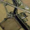
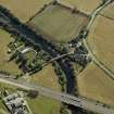
For (successor and present) New Bridge (NO 65117 66196), see NO66NE 106.
North Water Bridge (NAT)
OS 1:10,000 map, (1978)
EXTERNAL REFERENCE:
Scottish Record Office.
Upkeep of the Bridge upon thr North Esk commonly called the Northwater Bridge...
a common passage to the North of Scotland.
Permission to make it a toll bridge in order to keep it in repair granted by
King and estates of Parliament.
[Extract]
1669 GD 123/95
Account of disbursements for repairing the Northwater Bridge.
It amounts to £116.10.2.
1724 GD 123/426/21.
(Undated) information in NMRS.
The present bridge appears to be modern.
Visited by OS (J L D) 25 June 1958.
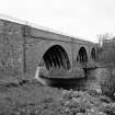
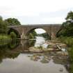
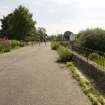
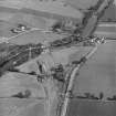
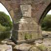
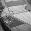
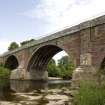
(Location cited as NO 653 662). Upper North Water Bridge (HBD No. 26 - cf NO66SE 21): 16th century, widened about 1800. A three-span bridge, with ribbed segmental arches. The five-arch ribs are of dressed stone, and the spandrels and wing walls are rubble.
Statistical Account (OSA) 1793; New Statistical Account (NSA) 1845; J R Hume 1977.
Upper North Water Bridge, 16th century, repaired 1809, widened 1841 (by John Gibb). Three arches with square ribs, decayed heraldic plaque on W side, and wroiught-iron parapet.
J Geddes 2001.
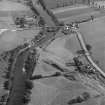
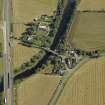
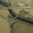
This bridge carries the former line of the A94 (T) public road across the River North Esk, which here forms the boundary between the parishes of Logie Pert (Angus) and Marykirk (Kincardineshire), to the SW and NE respectively.
The location assigned to this record defines the centre of the structure. The available map evidence suggests that it extends from NO c. 65270 66175 to NO c. 65269 66103.
Information from RCAHMS (RJCM), 11 April 2006.
Publication Account (2007)
This substantial bridge, of the pre-reformation era at the intersection of the old military roads from Edinburgh to Aberdeen and Fochabers, was built in the 1520s to span the North Esk. It has three spans of about 50 ft and ribbed semicircular arches and is of similar construction to the Bridge of Dee, Aberdeen. Both bridges were built under the aegis of Bishop Gavin Dunbar by Thomas Franche, master mason, to the design of Alexander Galloway Minister of Kinkeld.
R Paxton and J Shipway 2007b
Reproduced from 'Civil Engineering heritage: Scotland - Highlands and Islands' with kind permission of Thomas Telford Publishers.
Publication Account (2013)
Built in the 1520s, or 1539, by Thomas Franche, master mason. The three ribbed arches of 52’ span were widened in 1841 by John Gibb
M Watson, 2013

