
Old Montrose


Cursus(S) (Neolithic)
Site Name Old Montrose
Classification Cursus(S) (Neolithic)
Alternative Name(s) Powis
Canmore ID 35689
Site Number NO65NE 36
NGR NO 6639 5706
NGR Description From NO 6610 5713 to NO 6671 5699
Datum OSGB36 - NGR
Permalink http://canmore.org.uk/site/35689
Ordnance Survey licence number AC0000807262. All rights reserved.
Canmore Disclaimer.
© Copyright and database right 2024.
- Correction
- Favourite

SC 1005433
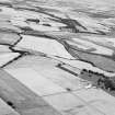
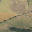
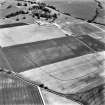
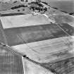
Oblique aerial view centred on the cropmarks of the enclosed settlement, ditch defined cursus, enclosure, ring ditches, barrows, pits and rig at Powis and Old Montrose, looking to the N.
Records of Aberdeen Aerial Surveys, Aberdeen, Scotland
8/8/1983
© Ian Ralston. Courtesy of HES

DP 163316
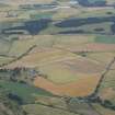
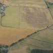
Oblique aerial view of the cropmarks of the cursus, barrows, enclosure and ring ditches, looking S.
RCAHMS Aerial Photography Digital
31/7/2013
© Crown Copyright: HES


SC 1721848
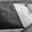
Oblique aerial view.
RCAHMS Aerial Photography
5/7/1994
© Crown Copyright: HES

SC 1721917
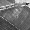
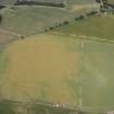
Oblique aerial view centred on the cropmarks of the cursus, enclosure, rig, barrows, and ring-ditch, taken from the ENE.
RCAHMS Aerial Photography
24/7/2003
© Crown Copyright: HES

SC 1721927
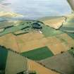
Oblique aerial view centred on the cropmarks of the cursus, enclosed and unenclosed settlement, rig, ring-ditch, barrows and an enclosure, taken from the WNW.
RCAHMS Aerial Photography
24/7/2003
© Crown Copyright: HES


SC 2410538
Old Montrose, NO65NE 36, Ordnance Survey index card, Recto
Records of the Ordnance Survey, Southampton, Hampshire, England
1958
© Crown Copyright: HES (Ordnance Survey Archaeology Division Collection)


SC 923494
Oblique aerial view centred on the cropmarks of square and round barrows, a probable roundhouse and the central portion of a ditch-defined cursus, taken from the ENE.
RCAHMS Aerial Photography
1982
© Crown Copyright: HES

SC 1113384
Oblique aerial view centred on the cropmarks of the cursus, enclosed and unenclosed settlement, rig, ring-ditch, barrows and an enclosure, taken from the WNW.
RCAHMS Aerial Photography
24/7/2003
© Crown Copyright: HES


SC 1721846
Oblique aerial view.
RCAHMS Aerial Photography
5/7/1994
© Crown Copyright: HES

SC 1721851
Oblique aerial view.
RCAHMS Aerial Photography
5/7/1994
© Crown Copyright: HES

SC 1721852
Oblique aerial view.
RCAHMS Aerial Photography
5/7/1994
© Crown Copyright: HES

SC 1721875
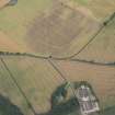
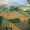
Powis, oblique aerial view taken from the SW, centred on the cropmarks of a possible cursus, an enclosure, barrows, pits and rig.
RCAHMS Aerial Photography
5/7/1994
© Crown Copyright: HES

SC 1721877
Powis, oblique aerial view taken from the SE, centred on the cropmarks of a possible cursus, an enclosure, barrows, pits and rig. The cropmarks of a second enclosure and an unenclosed settlement are also visible in this photograph to the bottom right hand corner.
RCAHMS Aerial Photography
5/7/1994
© Crown Copyright: HES

SC 1721904
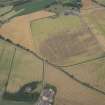
General oblique aerial view centred on the cropmarks of the cursus monuments, and the barrows, pits and rig with the farmsteading adjacent, taken from the SW.
RCAHMS Aerial Photography
3/8/2001
© Crown Copyright: HES

SC 1721907
Oblique aerial view centred on the cropmarks of the cursus monuments, with the barrows, pits and rig adjacent, taken from the SW.
RCAHMS Aerial Photography
3/8/2001
© Crown Copyright: HES

SC 1721926
Oblique aerial view centred on the cropmarks of the cursus, enclosure, rig, barrows, and ring-ditch, taken from the ENE.
RCAHMS Aerial Photography
24/7/2003
© Crown Copyright: HES

SC 2547535
Oblique aerial view centred on the cropmarks of the cursus, enclosure, rig, barrows, and ring-ditch, taken from the SE.
RCAHMS Aerial Photography
24/7/2003
© Crown Copyright: HES

SC 395956
Oblique aerial view.
RCAHMS Aerial Photography
5/7/1994
© Crown Copyright: HES

SC 925217
Oblique aerial view centred on the cropmarks of the cursus, enclosure, rig, barrows, and ring-ditch, taken from the SE.
RCAHMS Aerial Photography
24/7/2003
© Crown Copyright: HES

DP 163318
Oblique aerial view of the cropmarks of the cursus, barrows, enclosure and ring ditches, looking SE.
RCAHMS Aerial Photography Digital
31/7/2013
© Crown Copyright: HES

DP 163319
Oblique aerial view of the cropmarks of the cursus, barrows, enclosure, ring ditches and rig, looking ESE.
RCAHMS Aerial Photography Digital
31/7/2013
© Crown Copyright: HES

DP 166906
Oblique aerial view of cropmarks of the cursus, enclosure and rig, looking S.
RCAHMS Aerial Photography Digital
18/7/2013
© Crown Copyright: HES

DP 166907
Oblique aerial view of cropmarks of the cursus, enclosures, ring ditches and rig at Old Montrose, looking S.
RCAHMS Aerial Photography Digital
18/7/2013
© Crown Copyright: HES

DP 166909
Oblique aerial view of cropmarks of the cursus, enclosures, settlement and barrows, looking ESE.
RCAHMS Aerial Photography Digital
18/7/2013
© Crown Copyright: HES


SC 1721876
Powis, oblique aerial view taken from the SSE, centred on the cropmarks of a possible cursus, an enclosure, barrows, pits and rig. The cropmarks of a second enclosure and an unenclosed settlement are also visible in this photograph to the bottom right hand corner.
RCAHMS Aerial Photography
5/7/1994
© Crown Copyright: HES

SC 1721880
Powis and Old Montrose, oblique aerial view, taken from the NW, centred on the cropmarks of enclosures, an unenclosed settlement, ring-ditches and rig. The faint cropmark of a possible cursus is visible in the bottom left-hand corner of the photograph.
RCAHMS Aerial Photography
5/7/1996
© Crown Copyright: HES

SC 1721902
Oblique aerial view centred on the cropmarks of the cursus monuments, with the barrows, pits and rig adjacent, taken from the NE.
RCAHMS Aerial Photography
3/8/2001
© Crown Copyright: HES

SC 1721903
Oblique aerial view centred on the cropmarks of the cursus monuments, and the barrows, pits and rig with the farmsteading adjacent, taken from the WNW.
RCAHMS Aerial Photography
3/8/2001
© Crown Copyright: HES

SC 1721924
Oblique aerial view centred on the cropmarks of the cursus, enclosure, rig, barrows, and ring-ditch, taken from the SE.
RCAHMS Aerial Photography
24/7/2003
© Crown Copyright: HES

SC 1721925
Oblique aerial view centred on the cropmarks of the cursus, enclosure, rig, barrows, and ring-ditch, taken from the ESE.
RCAHMS Aerial Photography
24/7/2003
© Crown Copyright: HES

SC 1721929
Oblique aerial view centred on the cropmarks of the cursus, enclosed and unenclosed settlement, rig, ring-ditch, barrows and an enclosure, taken from the WSW.
RCAHMS Aerial Photography
24/7/2003
© Crown Copyright: HES


SC 2410537
Old Montrose, NO65NE 36, Ordnance Survey index card, page number 1, Recto
Records of the Ordnance Survey, Southampton, Hampshire, England
1958
© Crown Copyright: HES (Ordnance Survey Archaeology Division Collection)


SC 1013395
Oblique aerial view centred on the cropmarks of the enclosed settlement, ditch defined cursus, enclosure, ring ditches, barrows, pits and rig at Powis and Old Montrose, looking to the NW.
Records of Aberdeen Aerial Surveys, Aberdeen, Scotland
5/7/1982
© Ian Ralston. Courtesy of HES

DP 163320
Oblique aerial view of the cropmarks of the cursus, barrows, enclosure, ring ditches and rig, looking E.
RCAHMS Aerial Photography Digital
31/7/2013
© Crown Copyright: HES


SC 1721855
Oblique aerial view.
RCAHMS Aerial Photography
5/7/1994
© Crown Copyright: HES

SC 1721879
Powis and Old Montrose, oblique aerial view, taken from the E, centred on the cropmarks of enclosures, an unenclosed settlement, ring-ditches and rig. The faint cropmark of a possible cursus is visible in the centre right half of the photograph.
RCAHMS Aerial Photography
5/7/1996
© Crown Copyright: HES

SC 1721916
Oblique aerial view centred on the cropmarks of the cursus, enclosure, rig, barrows, and ring-ditch, taken from the E.
RCAHMS Aerial Photography
24/7/2003
© Crown Copyright: HES

SC 1783555
Oblique aerial view of Old Montrose and Powis centred on the cropmarks of a cursus monument and an enclosure, taken from the SSW.
RCAHMS Aerial Photography
1982
© Crown Copyright: HES

SC 1005432
Oblique aerial view centred on the cropmarks of the enclosed settlement, ditch defined cursus, enclosure, ring ditches, barrows, pits and rig at Powis and Old Montrose, looking to the NNW.
Records of Aberdeen Aerial Surveys, Aberdeen, Scotland
8/8/1983
© Ian Ralston. Courtesy of HES

DP 166904
Oblique aerial view of cropmarks of the cursus, enclosures, ring ditches and barrows at Old Montrose, looking SW.
RCAHMS Aerial Photography Digital
18/7/2013
© Crown Copyright: HES


SC 1721918
Oblique aerial view centred on the cropmarks of the cursus, enclosed and unenclosed settlement, rig, ring-ditch, barrows and an enclosure, taken from the WNW.
RCAHMS Aerial Photography
24/7/2003
© Crown Copyright: HES

SC 925218
Oblique aerial view centred on the cropmarks of the cursus, enclosed and unenclosed settlement, rig, ring-ditch, barrows and an enclosure, taken from the WNW.
RCAHMS Aerial Photography
24/7/2003
© Crown Copyright: HES

SC 1013394
Oblique aerial view centred on the cropmarks of the enclosed settlement, ditch defined cursus, enclosure, ring ditches, barrows, pits and rig at Powis and Old Montrose, looking to the NW.
Records of Aberdeen Aerial Surveys, Aberdeen, Scotland
5/7/1982
© Ian Ralston. Courtesy of HES

SC 1113385
Powis, oblique aerial view taken from the E, centred on the cropmarks of a possible cursus, an enclosure, barrows, pits and rig. The cropmarks of a second enclosure and an unenclosed settlement are also visible in this photograph to the bottom left.
RCAHMS Aerial Photography
5/7/1994
© Crown Copyright: HES

DP 163317
Oblique aerial view of the cropmarks of the cursus, barrows, enclosure and ring ditches, looking SE.
RCAHMS Aerial Photography Digital
31/7/2013
© Crown Copyright: HES

DP 166913
Oblique aerial view of cropmarks of the cursus, enclosures, settlement and barrows at Old Montrose, looking NW.
RCAHMS Aerial Photography Digital
18/7/2013
© Crown Copyright: HES


SC 1721849
Oblique aerial view.
RCAHMS Aerial Photography
5/7/1994
© Crown Copyright: HES

SC 1721854
Oblique aerial view.
RCAHMS Aerial Photography
5/7/1994
© Crown Copyright: HES

SC 1721881
Powis and Old Montrose, oblique aerial view, taken from the WNW, centred on the cropmarks of enclosures, an unenclosed settlement, ring-ditches and rig. The faint cropmark of a possible cursus is visible in the left half of the photograph.
RCAHMS Aerial Photography
5/7/1996
© Crown Copyright: HES

SC 1721906
Oblique aerial view centred on the cropmarks of the cursus monuments, with the barrows, pits and rig adjacent, taken from the WNW.
RCAHMS Aerial Photography
3/8/2001
© Crown Copyright: HES

SC 1721919
Oblique aerial view centred on the cropmarks of the cursus, enclosed and unenclosed settlement, rig, ring-ditch, barrows and an enclosure, taken from the W.
RCAHMS Aerial Photography
24/7/2003
© Crown Copyright: HES

SC 1721922
Oblique aerial view centred on the cropmarks of the cursus, enclosure, rig, barrows, and ring-ditch, taken from the SE.
RCAHMS Aerial Photography
24/7/2003
© Crown Copyright: HES

SC 1099877
Oblique aerial view centred on the cropmarks of the cursus, enclosed and unenclosed settlement, rig, ring-ditch, barrows and an enclosure, taken from the WSW.
RCAHMS Aerial Photography
24/7/2003
© Crown Copyright: HES

SC 1113386
Oblique aerial view of Old Montrose and Powis.
John Dewar
7/1976
© HES (John Dewar Collection)


SC 1721812
Oblique aerial view centred on the cropmarks of square and round barrows, a probable roundhouse and the central portion of a ditch-defined cursus, taken from the ENE.
RCAHMS Aerial Photography
1982
© Crown Copyright: HES


SC 1721847
Oblique aerial view.
RCAHMS Aerial Photography
5/7/1994
© Crown Copyright: HES

SC 1721850
Oblique aerial view.
RCAHMS Aerial Photography
5/7/1994
© Crown Copyright: HES

SC 1721905
General oblique aerial view centred on the cropmarks of the cursus monuments, and the barrows, pits and rig with the farmsteading adjacent, taken from the SSW.
RCAHMS Aerial Photography
3/8/2001
© Crown Copyright: HES

SC 1721908
Oblique aerial view centred on the cropmarks of the cursus monuments, with the barrows, pits and rig adjacent, taken from the SE.
RCAHMS Aerial Photography
3/8/2001
© Crown Copyright: HES

SC 1721921
Oblique aerial view centred on the cropmarks of the cursus, enclosed and unenclosed settlement, rig, ring-ditch, barrows and an enclosure, taken from the SW.
RCAHMS Aerial Photography
24/7/2003
© Crown Copyright: HES

SC 1721923
Oblique aerial view centred on the cropmarks of the cursus, enclosure, rig, barrows, and ring-ditch, taken from the SE.
RCAHMS Aerial Photography
24/7/2003
© Crown Copyright: HES

SC 1721928
Oblique aerial view centred on the cropmarks of the cursus, enclosed and unenclosed settlement, rig, ring-ditch, barrows and an enclosure, taken from the W.
RCAHMS Aerial Photography
24/7/2003
© Crown Copyright: HES


SC 1113387
Oblique aerial view of Old Montrose and Powis.
John Dewar
7/1976
© HES (John Dewar Collection)

DP 166905
Oblique aerial view of cropmarks of the cursus, enclosures, ring ditches and barrows at Old Montrose, looking SW.
RCAHMS Aerial Photography Digital
18/7/2013
© Crown Copyright: HES

DP 166908
Oblique aerial view of cropmarks of the cursus, enclosures, settlement and barrows, looking SE.
RCAHMS Aerial Photography Digital
18/7/2013
© Crown Copyright: HES


SC 1721853
Oblique aerial view.
RCAHMS Aerial Photography
5/7/1994
© Crown Copyright: HES

SC 1721874
Powis, oblique aerial view taken from the SW, centred on the cropmarks of a possible cursus, an unenclosed settlement and an enclosure.
RCAHMS Aerial Photography
5/7/1994
© Crown Copyright: HES

SC 1721878
Powis, oblique aerial view taken from the E, centred on the cropmarks of a possible cursus, an enclosure, barrows, pits and rig. The cropmarks of a second enclosure and an unenclosed settlement are also visible in this photograph to the bottom left.
RCAHMS Aerial Photography
5/7/1994
© Crown Copyright: HES


First 100 images shown. See the Collections panel (below) for a link to all digital images.
- Council Angus
- Parish Maryton
- Former Region Tayside
- Former District Angus
- Former County Angus
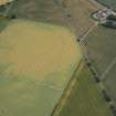
NO 669 566 A small amount of fieldwalking was undertaken in the vicinity of a series of cropmarks lying above the 15m contour on the valley floor. These include a large ditch-defined cursus, Old Montrose (NMRS NO65NE 36), several ring-ditches, round and square barrows, a souterrain, settlement (enclosed and unenclosed), and agricultural traces. They also include a large kidney-shaped enclosure and represent a complex and long-term sequence of human activity. A lithic scatter was previously known (Sherriff 1981). Rewalking produced waste flakes and chips of flint from NO 667 562: none has secondary working. In a field centred on NO 669 566 - downslope of the cropmarks - two chips and an awl or borer were found. All are of reddish flint. Other fields produced occasional flakes or pieces. More work will be done in this area.
Sponsor: Historic Scotland.
K Brophy and E Stewart 1997
Note (1978)
Old Montrose NO 661 571 to 667 568 NO65NE
A number of linear features forming large enclosures have been identified as crop-marks in the area between Powis and Old Montrose. At least three phases may be identified.
RCAHMS 1978
Aerial Photographic Transcription (3 December 1993 - 17 January 1994)
An aerial transcription was produced from oblique aerial photographs. Information from Historic Environment Scotland (BM) 31 March 2017.

