
Sanday, Hangie Head, Tres Ness


Broch (Iron Age)(Possible), Burial Cairn (Prehistoric)(Possible)
Site Name Sanday, Hangie Head, Tres Ness
Classification Broch (Iron Age)(Possible), Burial Cairn (Prehistoric)(Possible)
Alternative Name(s) Tresness
Canmore ID 3565
Site Number HY73NW 3
NGR HY 71199 38004
Datum OSGB36 - NGR
Permalink http://canmore.org.uk/site/3565


- Council Orkney Islands
- Parish Lady
- Former Region Orkney Islands Area
- Former District Orkney
- Former County Orkney
HY73NW 3 7120 3800.
(HY 7120 3800) Brough (NR)
OS 6" map, Orkney, 2nd ed,(1900).
A low mound which the Ordnance Survey Name Book (ONB) does not provide evidence for classifying as a broch, nor could RCAHMS see any.
Name Book 1879; RCAHMS 1946, visited 1928.
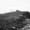
A low, natural knoll, eroded by the sea, overlaid by a modern wall and surmounted by a sea marker cairn. There is no trace of man-made structures in the cliff face.
Visited by OS (NKB) 14 July 1970.
Note (1980)
Tres Ness, Sanday HY 7120 3800 HY 73 NW 3
Preyiously regarded as natural, this knoll is 8m diameter and 1m high, and shows stonework in the cliff-section. Erosion is active.
RCAHMS 1980
(RCAHMS 1946, ii, p. 168, No. 446; OR 115)
Field Visit (1999)
A low mound, which may be artificial, lies adjacent to the coast edge. It is sub-oval in shape, measuring some 25m by 12m and stands no more than 1m high. A modern marker cairn has been constructed on its highest point. The seaward side of the mound has been damaged by coastal erosion and stonework, which appears to be of a structural nature, is exposed in an erosion face which extends for 10m and is up to 1m high. This area is used by nesting fulmars. To the north side of the mound can be seen the feint outline of a curvilinear earthwork. This is up to 2m in width and extends for 15m or more inland, running to the west of the mound. The Ref.: Orkney Name Book No.2, 1879; RCAHMS (1946) #446; RCAHMS (1980) #156.
Coastal Zone Assessment Survey, 1999
Publication Account (2002)
HY73 1 HANGIE HEAD
HY/712380
Possible broch in Lady parish on Sanday consisting of a low mound eroded by the sea. Previously regarded as natural, the mound now appears to contain stonework [3].
Sources: 1. OS card HY 73 NW 3: 2. RCAHMS 1946, 2, 168, no. 446: 3. Lamb 1980, 24, no. 156.
E W MacKie 2002
Field Visit (14 May 2015)
ShoreUPDATE
As described, some structural stone is visible at the south end including a wall face and possible paving. No cultural material is visible in the exposure. This site may be a burial cairn; there is a chambered cairn (a scheduled monument) at the tip of the point.
Visited by Scotland's Coastal Heritage at Risk (SCHARP) 14 May 2015
Orkney Smr Note
A low mound by the shore, no apparent justification for the
name Brough which appears on the 6 map. [R1]
Information from Orkney SMR [n.d.]

