 |
On-line Digital Images |
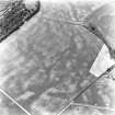
SC 624594 |
RCAHMS Aerial Photography |
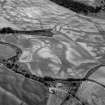
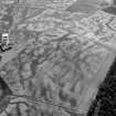
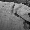
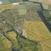
Boysack, oblique aerial view, taken from the S, centred on the cropmarks of an unenclosed settlement, a pit-defined enclosure and souterrains. A pit-enclosure is visible in the top centre half of the photograph. |
5/7/1996 |
Item Level |
|
 |
On-line Digital Images |
SC 1013426 |
Records of Aberdeen Aerial Surveys, Aberdeen, Scotland |
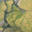
Oblique aerial view centred on the cropmarks of the unenclosed settlement, roundhouses, souterrain, rig and pits at Chapelton and Boysack, looking to the SE. |
5/7/1982 |
Item Level |
|
 |
On-line Digital Images |
SC 1013427 |
Records of Aberdeen Aerial Surveys, Aberdeen, Scotland |
Oblique aerial view centred on the cropmarks of the unenclosed settlement, roundhouses, souterrain, rig and pits at Chapelton and Boysack, looking to the SE. |
5/7/1982 |
Item Level |
|
 |
On-line Digital Images |
SC 1013433 |
Records of Aberdeen Aerial Surveys, Aberdeen, Scotland |
Oblique aerial view centred on the cropmarks of the unenclosed settlement, roundhouses, souterrain, rig and pits at Chapelton and Boysack, looking to the ESE. |
5/7/1982 |
Item Level |
|
 |
On-line Digital Images |
SC 1013437 |
Records of Aberdeen Aerial Surveys, Aberdeen, Scotland |
Oblique aerial view centred on the cropmarks of the unenclosed settlement, pit enclosure, roundhouses, souterrain and timber hall at Chapelton and Boysack, looking to the NW. |
5/7/1982 |
Item Level |
|
 |
On-line Digital Images |
SC 1013438 |
Records of Aberdeen Aerial Surveys, Aberdeen, Scotland |
Oblique aerial view centred on the cropmarks of the unenclosed settlement, pit enclosure, roundhouses, souterrain and timber hall at Chapelton and Boysack, looking to the WNW. |
5/7/1982 |
Item Level |
|
 |
On-line Digital Images |
SC 1013490 |
Records of Aberdeen Aerial Surveys, Aberdeen, Scotland |
Oblique aerial view centred on the cropmarks of the enclosure, timber hall, unenclosed settlement and pits at Boysack, looking to the SW. |
8/7/1982 |
Item Level |
|
 |
On-line Digital Images |
SC 1013491 |
Records of Aberdeen Aerial Surveys, Aberdeen, Scotland |
Oblique aerial view centred on the cropmarks of the enclosure, timber hall, unenclosed settlement and pits at Boysack, looking to the SSW. |
8/7/1982 |
Item Level |
|
 |
On-line Digital Images |
SC 1013492 |
Records of Aberdeen Aerial Surveys, Aberdeen, Scotland |
Oblique aerial view centred on the cropmarks of the enclosure, timber hall, unenclosed settlement and pits at Boysack, looking to the SSE. |
7/7/1982 |
Item Level |
|
 |
On-line Digital Images |
SC 1013858 |
Records of Aberdeen Aerial Surveys, Aberdeen, Scotland |
Oblique aerial view centred on the cropmarks of the unenclosed settlement, ring ditches, souterrains, enclosures, pits and rig at Boysack, looking to the W. |
7/1982 |
Item Level |
|
 |
On-line Digital Images |
SC 1013859 |
Records of Aberdeen Aerial Surveys, Aberdeen, Scotland |
Oblique aerial view centred on the cropmarks of the unenclosed settlement, ring ditches, souterrains, enclosures, pits and rig at Boysack, looking to the WSW. |
7/1982 |
Item Level |
|
 |
On-line Digital Images |
SC 1013862 |
Records of Aberdeen Aerial Surveys, Aberdeen, Scotland |
Oblique aerial view centred on the cropmarks of the unenclosed settlement, ring ditches, souterrains, enclosures, pits and rig at Boysack, looking to the N. |
7/1982 |
Item Level |
|
 |
On-line Digital Images |
SC 1013863 |
Records of Aberdeen Aerial Surveys, Aberdeen, Scotland |
Oblique aerial view centred on the cropmarks of the unenclosed settlement, ring ditches, souterrains, enclosures, pits and rig at Boysack, looking to the N. |
7/1982 |
Item Level |
|
 |
On-line Digital Images |
SC 1014672 |
Records of Aberdeen Aerial Surveys, Aberdeen, Scotland |
Oblique aerial view of the cropmarks of the enclosure, timber hall, unenclosed settlement and pits at Boysack, looking to the SSE. |
18/7/1984 |
Item Level |
|
 |
On-line Digital Images |
SC 1029396 |
RCAHMS Aerial Photography |
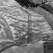
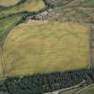
Boysack, oblique aerial view, taken from the NE, centred on the cropmarks of an unenclosed settlement, a pit-defined enclosure and souterrains. The cropmarks of a pit-enclosure are visible in the bottom right-hand corner of the photograph. |
4/7/1995 |
Item Level |
|
 |
On-line Digital Images |
DP 166890 |
RCAHMS Aerial Photography Digital |
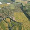
General oblique aerial view centred on the cropmarks of the enclosures, timber hall and unenclosed settlement, looking SSE. |
18/7/2013 |
Item Level |
|
 |
On-line Digital Images |
DP 166891 |
RCAHMS Aerial Photography Digital |
General oblique aerial view centred on the cropmarks of the enclosures, timber hall and unenclosed settlement, looking SSE. |
18/7/2013 |
Item Level |
|
 |
On-line Digital Images |
DP 166893 |
RCAHMS Aerial Photography Digital |
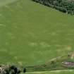
Oblique aerial view centred on the cropmarks of the unenclosed settlement, barrows, linear features and pits, looking SE. |
18/7/2013 |
Item Level |
|
 |
On-line Digital Images |
DP 166895 |
RCAHMS Aerial Photography Digital |
Oblique aerial view centred on the cropmarks of the unenclosed settlement, barrows, timber halls, linear features and pits, looking NE. |
18/7/2013 |
Item Level |
|
 |
On-line Digital Images |
DP 276463 |
Historic Environment Scotland |
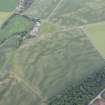
Oblique aerial view. |
22/6/2018 |
Item Level |
|
 |
On-line Digital Images |
SC 1720752 |
RCAHMS Aerial Photography |
Oblique aerial view |
1976 |
Item Level |
|
 |
On-line Digital Images |
SC 1720784 |
RCAHMS Aerial Photography |
Oblique aerial view. |
1978 |
Item Level |
|
 |
On-line Digital Images |
SC 1720785 |
RCAHMS Aerial Photography |
Oblique aerial view. |
1978 |
Item Level |
|
 |
On-line Digital Images |
SC 1720786 |
RCAHMS Aerial Photography |
Oblique aerial view. |
1978 |
Item Level |
|


