
Newton


Pit(S) (Period Unknown), Rig And Furrow (Medieval) - (Post Medieval), Ring Ditch(S) (Prehistoric), Roundhouse (Prehistoric), Souterrain (Iron Age)(Possible)
Site Name Newton
Classification Pit(S) (Period Unknown), Rig And Furrow (Medieval) - (Post Medieval), Ring Ditch(S) (Prehistoric), Roundhouse (Prehistoric), Souterrain (Iron Age)(Possible)
Canmore ID 35464
Site Number NO64NW 30
NGR NO 6090 4670
NGR Description Centred on NO 6090 4670 and NO 6093 4681
Datum OSGB36 - NGR
Permalink http://canmore.org.uk/site/35464


- Council Angus
- Parish Inverkeilor
- Former Region Tayside
- Former District Angus
- Former County Angus
Field Visit (March 1978)
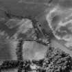
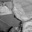
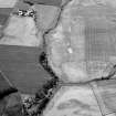
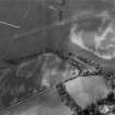
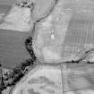
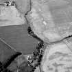
Newton NO 609 467 NO64NW
The crop-marks of what is probably a multi-period settlement site have been located on a gravel ridge NW of Mill of Colliston. At least three penannular marks, which probably represent ring-ditch houses, run in a line to the NW of the largest house which measures 8m in diameter within its ditch. To the W of these there is what is probably a souterrain, measuring about 10m in length and possibly associated with the remains of a ring-groove house. About 30m N of the souterrain there is a pit-circle measuring about 10m in internal diameter; a number of other pits are visible over the rest of the site.
RCAHMS 1978, visited March 1978
(For other sites visible on aerial photograph, see NO64NW 31 - 33).
Aerial Photographic Interpretation (26 February 2014)
Following a review of the aerial photographs, the pit circle classification has been changed to roundhouse.
Information from RCAHMS (KMM) 26 February 2014

