
West Mains Of Colliston


Enclosed Settlement (Prehistoric), Pit(S) (Period Unknown), Rig And Furrow (Medieval) - (Post Medieval)
Site Name West Mains Of Colliston
Classification Enclosed Settlement (Prehistoric), Pit(S) (Period Unknown), Rig And Furrow (Medieval) - (Post Medieval)
Canmore ID 35457
Site Number NO64NW 24
NGR NO 6058 4627
Datum OSGB36 - NGR
Permalink http://canmore.org.uk/site/35457


- Council Angus
- Parish Arbroath And St Vigeans
- Former Region Tayside
- Former District Angus
- Former County Angus
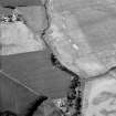
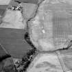
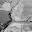
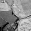
The settlement and rig, situated on a gentle rise at 45mOD adjacent to Colliston Burn, have been recorded as cropmarks on oblique aerial photographs (RCAHMSAP 2001). The settlement is enclosed by an enclosure that is roughly oval on plan, measuring 30m by 60m, and has a SE facing entrance. The rig, situated NW of the settlement, has a SSE to NNW orientation and a distance between furrows of around 10m. A field boundary (shown partially in the 1st edition map) runs across the field from NO 6072 4616 to NO 6061 4636.
Information from RCAHMS (VLW) 16 May 2006
Field Visit (March 1978)
West Mains of Colliston 1 NO 605 463 NO64NW
Aerial photography has revealed an oval enclosure NE of West Mains of Colliston. A broad mark, which measures up to 6m wide, encloses an area measuring about 50m from NE to SW by 30m transversely. There is an entrance on the SE side.
RCAHMS 1978, visited March 1978

